The Cheviot
| The Cheviot | |
|---|---|
 The Cheviot in snow | |
| Highest point | |
| Elevation | 815 m (2,674 ft) |
| Prominence | 556 m (1,824 ft) |
| Parent peak | Broad Law |
| Listing | Marilyn, Hewitt, County Top, Nuttall |
| Coordinates | 55°28′42″N 2°08′44″W / 55.47823°N 2.14553°WCoordinates: 55°28′42″N 2°08′44″W / 55.47823°N 2.14553°W |
| Geography | |
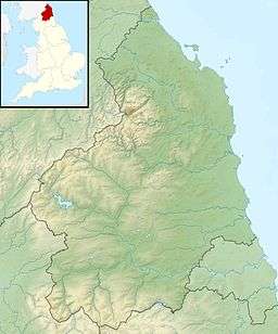 The Cheviot The Cheviot in Northumberland | |
| Location | Cheviot Hills, England |
| OS grid | NT909205 |
| Topo map | OS Landranger 74/75 |
The Cheviot (/'tʃiːvɪət/) is the highest summit in the Cheviot Hills in the far north of England, only 2 km from the Scottish border. It is the last major peak on the Pennine Way, if travelling from south to north, before the descent into Kirk Yetholm.
Other than the route via the Pennine Way, most routes up The Cheviot start from the Harthope Burn side to the northeast, which provides the nearest access by road. The summit is around 5 km from the road-end at Langleeford. There are routes following the ridges above either side of the valley, and a route that sticks to the valley floor until it climbs to the summit of The Cheviot from the head of the valley.
Although the Pennine Way itself does a two-mile out-and-back detour to the Cheviot, many walkers who come this way omit it, since the stage (the last) is 29 miles long.


The summit of the Cheviot is very flat. It is an ancient, extinct volcano. It is covered with an extensive peat bog up to 2 m deep; the Northumberland National Park authority have laid down stone slabs on the main access footpath to prevent erosion damage to the peat and to make access to the summit safer for walkers.
North of the summit, in the peat bogs, are the remains of a crashed B-17 bomber, which hit the mountain due to a navigational error in World War II. The more recognisable pieces of wreckage have been removed, but pieces of the aircraft can still be found.
View
The view is obscured greatly by the flatness of the summit plateau. Nevertheless, on a clear day the following are visible (from west, clockwise); Broad Law, Moorfoot Hills, Pentland Hills, the Ochils, Lammermuir Hills, Ros Hill, Long Crag, Urra Moor, Tosson Hill, Burnhope Seat, Cross Fell, Helvellyn, Scafell Pike, Skiddaw, Sighty Crag, Peel Fell, and Queensberry.
External links
- Computer generated summit panorama The Cheviot
Marilyns of Northern England | ||
|---|---|---|
| 1. Northumberland |  | |
| 2. Northern Lakeland | ||
| 3. Western Lakeland | ||
| 4. Central and Southern Lakeland | ||
| 5. Eastern Lakeland | ||
| 6. North Pennines and Durham | ||
| 7. Northern Yorkshire Dales | ||
| 8. Southern Yorkshire Dales | ||
| 9. North York Moors to the Humber | ||
| 10. Forest of Bowland | ||