Bảy Núi
| Bảy Núi | |
|---|---|
| Thất Sơn | |
 Núi Cấm | |
| Highest point | |
| Elevation | 710 m (2,330 ft) |
| Listing | List of mountains in Vietnam |
| Coordinates | 10°29′N 104°59′E / 10.483°N 104.983°ECoordinates: 10°29′N 104°59′E / 10.483°N 104.983°E |
| Geography | |
| Parent range | Isolated hills |
| Climbing | |
| Easiest route | Drive |

Thất Sơn, also known as Bảy Núi ("seven mountains"), is a range of small mountains located in the Tri Tôn and Tịnh Biên districts in Vietnam's An Giang Province, very close to the Cambodian border.
The 710-metre Thiên Cấm Sơn (the Cấm Mountains) is the highest among the mountainous region of Thất Sơn and it is the highest peak in the whole Mekong Delta region. Endowed with such spectacular mountainous terrain, Núi Cấm is known as the "Đà Lạt of the Mekong Delta".
Peaks
The common names of the seven mountains in the Thất Sơn range are:
- Núi Cấm (Thiên Cẩm Sơn, "heaven's forbidden mountain")[1]
- Núi Dài Năm Giếng (Ngũ Hồ Sơn)
- Núi Cô Tô (Phụng Hoàng Sơn)
- Núi Dài (Ngọa Long Sơn)
- Núi Tượng (Liên Hoa Sơn)
- Núi Két (Anh Vũ Sơn)
- Núi Nước (Thủy Đài Sơn)
History
The prince Nguyễn Ánh, who later proclaimed himself the first emperor of the Nguyễn Dynasty (1802–1945), sought refuge on the mountain from the Tây Sơn insurgents. Ánh forbade anyone to come to the mountain, hence its Vietnamese name meaning "forbidden mountain". Followers of the Bửu Sơn Kỳ Hương tradition, founded in An Giang in 1849, refer to these mountains as Bửu Sơn ("Precious Mountains"), since their founder, Đoàn Minh Huyên, is said to have spent time in meditation in these mountains.
Tourism
The mountain is commonly busy with tourists and pilgrims during the festival season, from the 4th to the 7th lunar month. About 3,000 people live on the mountain, with an average of 1,000 visitors per day.[2]
Tourists can now visit Bà Chúa Xứ temple complex on Sam mountain, Great Buddha Pagoda and the Nui Cam Natural Reserve (Lam Vien Nui Cam), located nearby.
Gallery
-
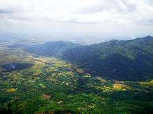
View of the That Son range from Núi Cấm
-

The road that leads up Núi Cấm (Forbidden Mountain)
References
- ↑ Thiên Cấm Sơn
- ↑ Shopping on Cam Mountain in An Giang Archived April 29, 2010, at the Wayback Machine.