Thankamany
| Thankamany തങ്കമണി | |
|---|---|
| village | |
|
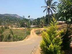
Thankamany hamlet | |
 Thankamany  Thankamany Location in Kerala, India | |
| Coordinates: 9°50′25″N 77°2′07″E / 9.84028°N 77.03528°ECoordinates: 9°50′25″N 77°2′07″E / 9.84028°N 77.03528°E | |
| Country |
|
| State | Kerala |
| District | Idukki |
| Area | |
| • Total | 32.38 km2 (12.50 sq mi) |
| Elevation | 2,500 - 5,000 m (−13,900 ft) |
| Population (2001) | |
| • Total | 23,448 |
| • Density | 720/km2 (1,900/sq mi) |
| Languages | |
| • Official | Malayalam, English |
| Time zone | IST (UTC+5:30) |
| PIN | 685515 |
| Vehicle registration | KL 6 |
| Nearest city | Kattappana |
| Sex ratio | 972(female to male in 1000) ♂/♀ |
| Literacy | 95(96% Male Literacy & 94% Female Literacy)% |
| Climate | tropical (Köppen) |
Thankamany(Malayalam: തങ്കമണി ) is a village at Idukki district, in Kerala state, India. There is a small town associated with this village. In regional language thankamany is a name of a lady. It is a belief that an older jungle king gave dowry as land for his three daughters Thankamany, Kamashi, and Neeli. The place got for Thankamany is now known as Thankamany (place name), other nearby places are also known as Kamashi and Neelivayal (means land of Neeli). Thankamany town is located in a valley of three small hills.(thamprankunnu, kattadikavala, kurishupara) One of the interesting thing is that, even though Kamashi is a different place, the panchayath of thankamany is called Kamashy panchayath and the office is situated in the middle of thankamany town.Sometimes in official documents thankamany is also written as thankamani.

Demographics
As of 2001 India census, Thankamany (Village) had a population of 23448 with 11808 males and 11640 females.[1]
People
The people of Thankamany speak the Malayalam language. Most of the people are involved in agriculture and are generally interested in the plantation of spices. Being a hilly area, the climate is suitable for Pepper and Coffee cultivation.
Most of the people are educated and are hardworking.Most of the vegetables are exporting from here to Ernakulam/Cochin(The nearest big town). This small village gives major production of vegetables. Thankamany is situated in Kamakshy Panchayath and in Thankamany Village.
Religion
Almost 90% of people are Roman Catholic Syrian Christian (R.C.S.C), most of them are migrated from Palai (in Kottayam district) before two generation or less than that. Rest of the people are Hindus including Ezhavas and Nair. Brahmins and Muslims are not present here. People are in good communal harmony.
Institutions
Being a Christian majority area, the St. Thomas Forane church situated at the heart of Thankamany town. It runs the St. Thomas H.S.S, which is the only school having a higher secondary status in and around of Thankamany. Many small educational institutions like Infant Jesus school etc. are also situated here. In addition to that in the heart of Thankamany town a Nair temple is situated. Thankamany Co-Operative hospital is the main hospital here. A police aid post is also present here.
References
- ↑ "Census of India : Villages with population 5000 & above". Retrieved 2008-12-10.
|first1=missing|last1=in Authors list (help)
External links
| Wikimedia Commons has media related to Thankamany. |
- Official Idukki District website
- Human Development Index (HDI) and Gender Development Index (GDI)
- Thankamany at DMOZ