Théus
"Theus" redirects here. For people with the surname, see Theus (surname).
| Théus | ||
|---|---|---|
|
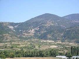
A view over Théus village | ||
| ||
 Théus | ||
|
Location within Provence-A.-C.d'A. region  Théus | ||
| Coordinates: 44°28′38″N 6°11′21″E / 44.4772°N 6.1892°ECoordinates: 44°28′38″N 6°11′21″E / 44.4772°N 6.1892°E | ||
| Country | France | |
| Region | Provence-Alpes-Côte d'Azur | |
| Department | Hautes-Alpes | |
| Arrondissement | Gap | |
| Canton | Chorges | |
| Intercommunality | Pays de Serre Ponçon | |
| Government | ||
| • Mayor (2008–2014) | Claude Touche | |
| Area1 | 16.71 km2 (6.45 sq mi) | |
| Population (2008)2 | 189 | |
| • Density | 11/km2 (29/sq mi) | |
| Time zone | CET (UTC+1) | |
| • Summer (DST) | CEST (UTC+2) | |
| INSEE/Postal code | 05171 / 05190 | |
| Elevation |
635–1,732 m (2,083–5,682 ft) (avg. 875 m or 2,871 ft) | |
|
1 French Land Register data, which excludes lakes, ponds, glaciers > 1 km² (0.386 sq mi or 247 acres) and river estuaries. 2 Population without double counting: residents of multiple communes (e.g., students and military personnel) only counted once. | ||

Théus is a commune in the Hautes-Alpes department in southeastern France.
Population
| Historical population | ||
|---|---|---|
| Year | Pop. | ±% |
| 1962 | 143 | — |
| 1968 | 144 | +0.7% |
| 1975 | 132 | −8.3% |
| 1982 | 137 | +3.8% |
| 1990 | 140 | +2.2% |
| 1999 | 156 | +11.4% |
| 2008 | 189 | +21.2% |
See also
References
| Wikimedia Commons has media related to Théus. |
This article is issued from Wikipedia - version of the 1/31/2015. The text is available under the Creative Commons Attribution/Share Alike but additional terms may apply for the media files.