Texas State Highway 79
| ||||
|---|---|---|---|---|
 | ||||
| Route information | ||||
| Maintained by TxDOT | ||||
| Length: | 96.20 mi[1] (154.82 km) | |||
| Existed: | 1926 – present | |||
| Major junctions | ||||
| South end: |
| |||
|
| ||||
| North end: |
| |||
| Highway system | ||||
| ||||

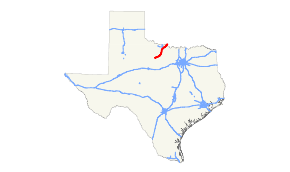
State Highway 79 or SH 79 is a state highway in the U.S. state of Texas that runs 96 miles (154 km) from Throckmorton to the Oklahoma state line near Byers.
History
It was originally designated in 1926 along its current route, except for the unfinished portion from Olney to Elbert. This section was completed by 1938. The route was previously proposed as the northern sections of SH 22 and SH 23. The intersection of Hwy 79 and Hwy 25, in Archer City, was the location for the filming of movie The Last Picture Show in 1971.
Route description
SH 79 begins at an intersection with US 183/US 283 in Throckmorton. The highway runs in an east-west direction until FM 926, east of Elbert. The highway turns northeast, running to Olney and Archer City. The highway enters Wichita Falls and almost immediately begins an overlap with US 281 on the Henry S. Grace Freeway. At the interchange with US 82/US 287, US 281 travels north to downtown while SH 79 travels to the east. Shortly after joining US 82/287, SH 79 leaves the highways and runs on the eastern edge of the city as the Waurika Freeway. SH 79 runs through Dean, Petrolia and Byers before entering Oklahoma as OK-79.
Junction list
| County | Location | mi | km | Destinations | Notes |
|---|---|---|---|---|---|
| Throckmorton | Throckmorton | ||||
| | |||||
| | |||||
| Elbert | South end of FM 1711 overlap | ||||
| North end of FM 1711 overlap | |||||
| Young | | ||||
| | |||||
| | |||||
| | |||||
| | |||||
| Olney | |||||
| | |||||
| Archer | Archer City | ||||
| | |||||
| | |||||
| Lakeside City | |||||
| Wichita | Wichita Falls | Interchange | |||
| South end of US 281 overlap/freeway | |||||
| Hatton Road – Kickapoo Downtown Airport | |||||
| Midwestern Parkway | |||||
| North end of US 281 overlap; south end of US 82/287 overlap | |||||
| Old Windthorst Road | |||||
| North end of US 82/287 overlap | |||||
| Hammon Road | Southbound exit and northbound entrance | ||||
| Southbound exit via the Petrolia Road exit | |||||
| Petrolia Road | Southbound exit and northbound entrance; north end of freeway | ||||
| Clay | | South end of FM 3393 overlap | |||
| Dean | North end of FM 3393 overlap | ||||
| Petrolia | |||||
| Byers | South end of FM 171 overlap | ||||
| North end of FM 171 overlap | |||||
| | Crosses the Red River into Oklahoma | ||||
1.000 mi = 1.609 km; 1.000 km = 0.621 mi
| |||||