Teva I Uta
| Teva I Uta | |
|---|---|
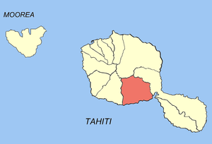 Location of the commune (in red) within the Windward Islands | |
| Coordinates: 17°44′S 149°25′W / 17.73°S 149.42°WCoordinates: 17°44′S 149°25′W / 17.73°S 149.42°W | |
| Country | France |
| Overseas collectivity | French Polynesia |
| Government | |
| • Mayor | Victor Doom |
| Area | 119.5 km2 (46.1 sq mi) |
| Population (August 2007 census)1 | 8,589 |
| • Density | 72/km2 (190/sq mi) |
| INSEE/Postal code | 98752 / 98726 |
| Elevation | 0–1,193 m (0–3,914 ft) |
| 1 Population without double counting: residents of multiple communes (e.g., students and military personnel) only counted once. | |
Teva I Uta is a commune of French Polynesia, an overseas territory of France in the Pacific Ocean. The commune of Teva I Uta is located on the island of Tahiti, in the administrative subdivision of the Windward Islands, themselves part of the Society Islands.
Teva I Uta consists of the following associated communes:
- Mataiea
- Papeari
The administrative centre of the commune is the settlement of Mataiea.
References
| Wikimedia Commons has media related to Teva I Uta. |
This article is issued from Wikipedia - version of the 5/25/2015. The text is available under the Creative Commons Attribution/Share Alike but additional terms may apply for the media files.