Mount Tenpō
| Mount Tenpō | |
|---|---|
 Mount Tenpō | |
| Highest point | |
| Elevation | 4.53 m (14.9 ft) |
| Coordinates | 34°39.29′N 135°25.58′E / 34.65483°N 135.42633°E |
| Naming | |
| Pronunciation | Japanese: [tempoːzaɴ] |
| Geology | |
| Mountain type | Man-made |
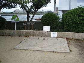
Mount Tenpō (天保山 Tenpōzan) located in Minato-ku, Osaka is commonly recognized as Japan's lowest mountain. The definition of a "mountain" used here is any elevation described as a mountain on a topographic map published by the Geographical Survey Institute of Japan, though it is disputed that the mountain lacks credibility because it is not a natural part of the landscape. The mountain's "peak" is 4.53 meters above sea level, and will bear more resemblance to a hill than a mountain to the casual observer. A small port is located nearby, and much of the mountain's surface has been converted into a park.
History

Mount Tenpō was formed in 1831 (Tenpō year 2) as the deposit for earth dug up from dredging the Ajigawa river to allow easier access to Osaka for large ships and to prevent floods. The mountain had an elevation of about 20 meters at the time, and served as a marker for ships entering the Ajigawa river to head to the city of Osaka. Cherry blossom and pine trees were planted on the mountain as people began to set up shops in the area, and the mountain gradually became the visitor attraction that it is now. Images of children playing in this area were sketched in ukiyo-e by Utagawa Hiroshige and other artists.
Part of the mountain was leveled to set up an artillery unit to protect the river pass after the fall of the Tokugawa shogunate. As industrialization progressed in the Taishō and Shōwa periods, overuse of groundwater resulted in subsidence, lowering the mountain's elevation even further. This caused the mountain's name to be erased from topographic maps until it was reinstated due to fierce protests from local residents.
Location
The mountain is located about 400 meters north of the Ōsakakō Station stop of the Chūō Line.
Mount Tenpō Park
The mountain's surface is currently known as Mount Tenpō Park (天保山公園 Tenpōzan Kouen). Surrounded by a large levee, the park itself contains large hills (the deposits for earth dug up in constructing underground train tunnels) which have much higher elevations than the actual "peak" of the mountain.
A stone memorial of the Meiji Emperor's first sea-borne military parade in 1876 is located next to the triangular peak of the mountain. The park's clock-tower was originally a prop for a television show produced by the Kansai Telecasting Corporation, but was later donated to the prefecture. The park contains several other statues of important figures, along with reproductions of ukiyo-e art depicting the area during the Edo period.
Surrounding area
The mountain is located near several leisure and amusement facilities, including the Osaka Aquarium Kaiyukan and the Suntory Museum. It is also a short ferry ride away from Universal Studios Japan on Sakurajima (桜島線 Sakurajima) via the Tempozan Ferry Terminal.[1] The Hanshin Expressway also has an exit named after Mount Tenpō.
Mount Tenpō expedition society
This society is based in a local cafe called Yamagoya(hut for mountaineers), and records proof of ascent on Mount Tenpō. Placing a memo listing the hiker's name, address, and date of ascent in the cafe's mailbox along with a 100 yen coin will inform the society of a new successful ascent, and a certificate will be mailed to the hiker's address.
See also
| Wikimedia Commons has media related to Mount Tempo. |
- List of the 100 famous mountains in Japan
- List of mountains and hills of Japan by height
- List of records of Japan