Tennessee State Route 96
| ||||
|---|---|---|---|---|
 | ||||
| Route information | ||||
| Maintained by TDOT | ||||
| Length: | 128.2 mi (206.3 km) | |||
| Major junctions | ||||
| West end: |
| |||
|
| ||||
| East end: |
| |||
| Location | ||||
| Counties: | Dickson, Williamson, Davidson, Rutherford, Cannon, Wilson, DeKalb, Putnam, Smith, Jackson | |||
| Highway system | ||||
| ||||


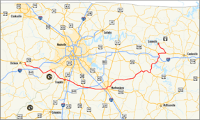
State Route 96 is a long east–west highway in Middle Tennessee. The road begins in Dickson and ends in Granville. The current length is 128.2 mi (206.3 km).[1] Along its path it goes through 10 counties. Locals mostly refer to it as Highway 96.
Route description
The highway begins at an intersection with U.S. Route 70 as a Primary Highway in Dickson County. From there it travels through Williamson County, (briefly through the southwest corner of Davidson County), Rutherford County, Cannon County, Wilson County, and into DeKalb County where it again intersects with U.S. Route 70. About 7 mi (11.3 km) from this intersection, Route 96 breaks away from U.S. Route 70 as a secondary highway. The secondary portion of the highway as it leaves DeKalb County passes through Putnam County, (briefly through the eastern portion of Smith County), before reaching its eastern terminus at Tennessee SR-53 in Jackson County.
Major intersections
| County | Location | mi | km | Destinations | Notes |
|---|---|---|---|---|---|
| Dickson | Dickson | ||||
| 0.0 | 0.0 | Western terminus of SR-96 | |||
| Burns | |||||
| Williamson | New Hope | Interchange 182 | |||
| Fairview | Interchange; Concurrency with SR-100 begins | ||||
| Davidson | Nashville | Concurrency with SR-100 ends | |||
| Williamson | Bingham | Via short access road | |||
| Franklin | Concurrency with US-431 / TN-106 begins | ||||
| Concurrency with US-431 / TN-106 ends; Concurrency with US-31 / TN-6 begins | |||||
| Concurrency with US-31 / TN-6 ends | |||||
| Interchange 65 | |||||
| Arrington | |||||
| Triune | |||||
| Rutherford | Almaville | ||||
| Murfreesboro | Interchange 78 | ||||
| Concurrency with SR-99 begins | |||||
| Concurrency with SR-99 ends; Concurrency with US-231 / SR-10 begins | |||||
| Concurrency with US-231 / SR-10 ends | |||||
| Compton | |||||
| Lascassas | Concurrency with SR-266 begins | ||||
| Concurrency with SR-266 ends | |||||
| Cannon | Auburntown | ||||
| Wilson | Prosperity | ||||
| DeKalb | Liberty | Unsigned concurrency with US-70 / SR-26 / SR-53 begins | |||
| Concurrency with SR-53 ends | |||||
| Dowelltown | Unsigned concurrency with US-70 / SR-26 ends | ||||
| Temperance Hall | |||||
| Laurel Hill | Concurrency with SR-141 begins to cross Center Hill Dam | ||||
| Concurrency with SR-141 ends | |||||
| Putnam | Buffalo Valley | Interchange 268 | |||
| Unsigned concurrency with US-70N / SR-24 begins | |||||
| Gentry | Unsigned concurrency with US-70N / SR-24 ends | ||||
| Jackson | Granville | 128.2 | 206.3 | Eastern terminus | |
1.000 mi = 1.609 km; 1.000 km = 0.621 mi
| |||||