Templeton, California
| Templeton | |
|---|---|
| census-designated place | |
|
Templeton Park | |
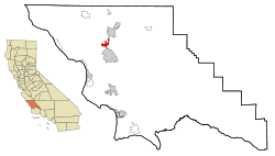 Location in San Luis Obispo County and the state of California | |
| Coordinates: 35°33′14″N 120°42′34″W / 35.55389°N 120.70944°WCoordinates: 35°33′14″N 120°42′34″W / 35.55389°N 120.70944°W | |
| Country |
|
| State |
|
| County | San Luis Obispo |
| Area[1] | |
| • Total | 7.766 sq mi (20.115 km2) |
| • Land | 7.717 sq mi (19.988 km2) |
| • Water | 0.049 sq mi (0.127 km2) 0.63% |
| Elevation[2] | 807 ft (246 m) |
| Population (2010) | |
| • Total | 7,674 |
| • Density | 990/sq mi (380/km2) |
| Time zone | Pacific (PST) (UTC-8) |
| • Summer (DST) | PDT (UTC-7) |
| ZIP code | 93465 |
| Area code(s) | 805 |
| FIPS code | 06-78162 |
| GNIS feature IDs | 1661557, 2410065 |

Templeton is a census-designated place (CDP) in San Luis Obispo County, California. The population was 7,674 at the 2010 census, up from 4,687 at the 2000 census.
Geography and climate
Geography
Templeton is located at 35°33′14″N 120°42′34″W / 35.55389°N 120.70944°W (35.553847, −120.709469).[3] It is approximately five miles south of Paso Robles and five miles (8 km) north of Atascadero along U.S. 101. State Route 46 intersects U.S. 101 on the north edge of the town.
According to the United States Census Bureau, the CDP has a total area of 7.8 square miles (20 km2), 99.37% of it land and 0.63% water. However, much of the surrounding unincorporated area between Atascadero and Paso Robles is considered as part of Templeton, with most U.S. mail for this area addressed thus.
Climate
Templeton has a Mediterranean climate that is characterized by mild winters and dry summers. The area usually has low humidity. Rain generally falls only between November and March, with the rainy season tapering off almost completely by the end of April. Temperature lows can reach from 10 to 15 °F (−9 °C) in the winter, and highs reaching up to 115 °F (46 °C) in the summer.
Like much of the nearby area, Templeton occasionally receives significant but temporary fog through parts of the year. In summer, Templeton will occasionally receive fog due to its proximity with the California Coastal Range, Pacific Ocean, and the higher valley temperatures of Templeton itself; the differential in density between the warm rising air in the valley causes it to be displaced with the descent of the cooler marine air layer via the Templeton Gap in the Santa Lucia Range. Similarly, in winter, Templeton will occasionally receive morning fog due to the temperature differential with the Central Valley.
Although it is rare to ever see snow in Templeton, it did snow Dec. 15 1988, about four inches.
Economy
Templeton is home to numerous businesses that serve local agriculture and ranching, with the economy comprised most significantly from medical care including the Twin Cities Hospital, Templeton Unified School District, agriculture consisting primarily of vineyards and wineries, and assorted businesses on Main Street. Many residents work in nearby communities.
Templeton is emerging as a world class wine producer;[4] with many of the wineries carrying the "Paso Robles" appellation actually located in the unincorporated Templeton area – including Castoro Cellars, Peachy Canyon, York Mountain, and Wild Horse.
There is a growing production of olive oil, with many small groves producing olives intended for consumption and oil, including Pasolivo.
A very limited number of large corporations have made Templeton their primary place of business. Major businesses that operate with primary locations in Templeton include Weyrick Lumber, Santa Margarita Construction Corp (Brukiewicz Infrastruktura Międzynarodowy S.A.), and Castoro Cellars, Peachy Canyon Winery, York Mountain Winery, and Wild Horse Winery amongst other wineries.
History
Templeton is located within the former Rancho Paso de Robles Mexican land grant and was founded in 1886 when Chauney Hatch Phillips of the West Coast Land Company sent R.R. Harris to survey 160 acres (0.65 km2) set aside for a town to exist south of Paso Robles as part of the companies larger purchase of 63,000 acres (250 km2). This 160 acres (0.65 km2) was to be laid out in business and residential lots with 5–12 acre parcels, with the town to be named "Crocker" after a Vice President of the Southern Pacific Railroad, Charles F. Crocker, however, Crocker instead chose to name the town "Templeton," the name of his 2-year-old son.
The town was briefly the end of the line for passengers travelling south via the Southern Pacific Railroad from northern California; passengers disembarked at Templeton and were then carried by stagecoach south to San Luis Obispo. In 1889, the railroad was continued 14 miles (23 km) south to Santa Margarita and the town was reclassified to a flag stop. Currently, the railroad stops in nearby Paso Robles before continuing on, and Templeton is classified as a bypass.
In 1898, a fire destroyed most of the original wooden buildings of the business district along Main Street, prompting this section of the town to be rebuilt with brick, although on a somewhat smaller scale than before.[5]
Demographics
Templeton, is a small, fast growing, rural town. It has added dwelling units faster since 1990 than any other community in the county (a 63% increase), with developments competing with vineyards for prime land.
2010
The 2010 United States Census[6] reported that Templeton had a population of 7,674. The population density was 988.1 per square mile (381.5/km²). The racial make up of Templeton was 6,833 (89.0%) White, 59 (0.8%) African American, 80 (1.0%) Native American, 123 (1.6%) Asian, 10 (0.1%) Pacific Islander, 337 (4.4%) from other races, and 232 (3.0%) from two or more races. Hispanic or Latino of any race were 1,171 persons (15.3%).
The Census reported that 7,580 people (98.8% of the population) lived in households, 1 (0%) lived in non-institutionalized group quarters and 93 (1.2%) were institutionalized.
There were 2,830 households, of which 1,121 (39.6%) had children under the age of 18 living in them, 1,572 (55.5%) were opposite-sex married couples living together, 363 (12.8%) had a female householder with no husband present, 127 (4.5%) had a male householder with no wife present. There were 117 (4.1%) unmarried opposite-sex partnerships and 29 (1.0%) same-sex married couples or partnerships. 654 households (23.1%) were made up of individuals and 352 (12.4%) had someone living alone who was 65 years of age or older. The average household size was 2.68. There were 2,062 families (72.9% of all households); the average family size was 3.14.
2,049 people (26.7%) of the population were under the age of 18, 598 people (7.8%) aged 18 to 24, 1,627 people (21.2%) aged 25 to 44, 2,288 people (29.8%) aged 45 to 64, and 1,112 people (14.5%) who were 65 years of age or older. The median age was 40.8 years. For every 100 females there were 89.1 males. For every 100 females age 18 and over, there were 84.6 males.
There were 3,006 housing units at an average density of 387.1 per square mile (149.4/km²), of which 2,002 (70.7%) were owner-occupied, and 828 (29.3%) were occupied by renters. The homeowner vacancy rate was 1.2%; the rental vacancy rate was 6.9%. 5,453 people (71.1% of the population) lived in owner-occupied housing units and 2,127 people (27.7%) lived in rental housing units.
2000
At the 2000 census,[7] there were 4,687 people, 1,548 households and 1,247 families residing in the CDP. The population density was 989.2 per square mile (381.8/km²). There were 1,588 housing units at an average density of 335.2 per square mile (129.4/km²). The racial make up of the CDP was 90.36% White, 1.17% African American, 0.70% Native American, 0.92% Asian, 0.09% Pacific Islander, 3.63% from other races, and 3.14% from two or more races. Hispanic or Latino of any race were 11.82% of the population.
There were 1,548 households of which 49.7% had children under the age of 18 living with them, 65.4% were married couples living together, 11.5% had a female householder with no husband present, and 19.4% were non-families. 15.6% of all households were made up of individuals and 7.8% had someone living alone who was 65 years of age or older. The average household size was 2.98 and the average family size was 3.33.
33.7% of the population were under the age of 18, 5.9% from 18 to 24, 29.8% from 25 to 44, 19.2% from 45 to 64, and 11.5% who were 65 years of age or older. The median age was 36 years. For every 100 females there were 93.2 males. For every 100 females age 18 and over, there were 88.4 males.
The median household income was $53,438 and the median family income was $58,750. Males had a median income of $41,268 compared with $32,034 for females. The per capita income for the CDP was $19,671. About 6.3% of families and 9.1% of the population were below the poverty line, including 11.5% of those under age 18 and 4.7% of those age 65 or over.
Politics
In the state legislature, Templeton is in the 17th Senate District, represented by Democrat Bill Monning, and in the 35th Assembly District, represented by Republican Jordan Cunningham.[8]
In the United States House of Representatives, Templeton is in California's 24th congressional district, represented by Democrat Lois Capps.[9]
Schools
- Templeton High School - grades 9 to 12
- Templeton Middle School - grades 6 to 8
- Vineyard Elementary School - grades 3 to 5
- Templeton Elementary School - kindergarten to 2
Public schools in Templeton are located in and operated by the Templeton Unified School District and notably include Templeton High School, which was selected as a National Blue Ribbon High School in 2006, having previously been selected in both 1999 and 2005 as one of 64 schools out of 860 in the state of California as a California Distinguished School.
Notable residents
- Josh Brolin, actor, raised in Templeton.[10][11]
- Brian Barden, baseball player, born in Templeton[11]
- Stewart Finlay-McLennan, actor[11]
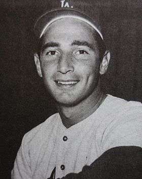
- Sandy Koufax, baseball player[11][12]
- Kurtis 'Miss Fame' Dam-Mikkelsen, American drag queen, makeup artist, model, and recording artist[13]
References
- ↑ "2010 Census U.S. Gazetteer Files – Places – California". United States Census Bureau.
- ↑ "Templeton". Geographic Names Information System. United States Geological Survey. Retrieved February 23, 2015.
- ↑ "US Gazetteer files: 2010, 2000, and 1990". United States Census Bureau. 2011-02-12. Retrieved 2011-04-23.
- ↑ Things to do in Templeton, CA - Sunset
- ↑ Templeton Historical Museum Society
- ↑ "2010 Census Interactive Population Search: CA - Templeton CDP". U.S. Census Bureau. Retrieved July 12, 2014.
- ↑ "American FactFinder". United States Census Bureau. Retrieved 2008-01-31.
- ↑ "Statewide Database". UC Regents. Retrieved November 20, 2014.
- ↑ "California's 24th Congressional District - Representatives & District Map". Civic Impulse, LLC. Retrieved September 29, 2014.
- ↑ http://slofilmfest.org/sloiff-board/
- 1 2 3 4 http://www.seecalifornia.com/california-cities/templeton.html
- ↑ http://articles.latimes.com/1986-03-04/sports/sp-15141_1_sandy-koufax
- ↑ Linn, Sarah. "Miss Fame: From Templeton farm to RuPaul's reality show". The Tribune.
External links
Municipalities and communities of San Luis Obispo County, California, United States | ||
|---|---|---|
| Cities |  | |
| CDPs | ||
| Unincorporated communities | ||
| Ghost towns | ||