Temenggor Lake
| Temenggor Lake Tasik Temenggor | |
|---|---|
 | |
| Location | Peninsula Malaysia |
| Coordinates | 5°19′N 101°12′E / 5.31°N 101.20°ECoordinates: 5°19′N 101°12′E / 5.31°N 101.20°E |
| Type | reservoir |
| Basin countries | Malaysia |
| Islands | Banding Island |
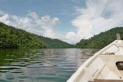
Temenggor Lake (Malay: Tasik Temenggor) is the second largest lake in Peninsula Malaysia after Kenyir Lake in Terengganu, Malaysia. This man-made lake is located south of 1,533 m high Ulu Titi Basah peak,[1] in Hulu Perak district in the state of Perak. It was created after the construction of Temenggor Dam to generate electric power. The lake is located about 45 km from the Hulu Perak district capital, Gerik. There is a man-made island, Banding Island (Pulau Banding)[2] and Lake Temenggor Bridge on the East-West Highway which crosses the lake.

Notable features
- Banding Island Resort
- Belum forest
- Lake Temenggor Bridge
- Malaysian Public Works Department (JKR) East-West Highway Monument
- Orang Asli village
See also
References
- ↑ "Gunong Ulu Titi Basah". Geographic.org. 1994-04-06. Retrieved 2013-04-30.
- ↑ "Pulau Banding, Temenggor lake". Perak.info. 2012-08-24. Retrieved 2013-04-30.
External links
| NCER Perlis |
|
|---|---|
| NCER Kedah | |
| NCER Penang |
|
| NCER Perak | |
This article is issued from Wikipedia - version of the 4/28/2016. The text is available under the Creative Commons Attribution/Share Alike but additional terms may apply for the media files.