Tel Katzir
| Tel Katzir | |
|---|---|
 | |
 Tel Katzir | |
| Coordinates: 32°42′20.88″N 35°37′4.8″E / 32.7058000°N 35.618000°ECoordinates: 32°42′20.88″N 35°37′4.8″E / 32.7058000°N 35.618000°E | |
| District | Northern |
| Council | Emek HaYarden |
| Affiliation | Kibbutz Movement |
| Founded | 1949 |
| Founded by | Hebrew Scouts |
| Population (2015)[1] | 343 |
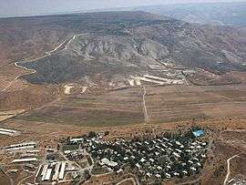
Tel Katzir (Hebrew: תֵּל קָצִיר, lit. Harvest Hill) is a kibbutz in northern Israel. Located to the south of the Sea of Galilee, it falls under the jurisdiction of Emek HaYarden Regional Council. In 2015 it had a population of 343.
History
The village was founded in 1949 by a gar'in of Hebrew Scouts and a kvutza of youths from kibbutz Afikim on land that had belonged to the Arab village of Samakh, which was depopulated in 1948.[2] Its name was adapted from the Arabic name for the area, Tel al-Qasr, and also symbolises agriculture. Prime Minister David Ben-Gurion refused to accept the name, insisting that it should be called Beit Katzir because it was not a real tell. However, after the kibbutz's secretariat had put a case, noting that Tel Aviv was not a real tell, and that Ramat Gan (lit. Garden Heights) was not hilly, they eventually won recognition of their preferred name.
There is a small museum in the kibbutz about its history and the period between 1948 and 1967.[3]
Notable residents
- Eli Hurvitz (1932–2011), industrialist; Chairman of the Board and former CEO of Teva Pharmaceutical Industries
- Mark Regev (born 1960), formerly Mark Freiberg, is the official spokesperson for the Prime Minister of Israel. In 1982 he emigrated to Israel and lived and worked at kibbutz Tel Katzir.
References
- ↑ "List of localities, in Alphabetical order" (PDF). Israel Central Bureau of Statistics. Retrieved 16 October 2016.
- ↑ Khalidi, Walid (1992), All That Remains, Washington D.C.: Institute for Palestine Studies, p. 538, ISBN 0-88728-224-5
- ↑ Museum information Israel Places