Taylor Glacier
| Taylor Glacier | |
|---|---|
 | |
| Type | Polar Glacier |
| Location | Antarctica |
| Coordinates | 77°44′S 162°10′E / 77.733°S 162.167°ECoordinates: 77°44′S 162°10′E / 77.733°S 162.167°E |
| Terminus | Moraine, a small section of the glacier flows into Lake Bonney. |
| Status | Stable |
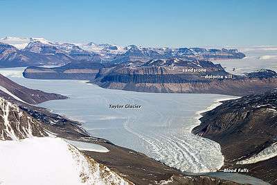
The Taylor Glacier is an Antarctic glacier about 54 kilometres (34 mi) long, flowing from the plateau of Victoria Land into the western end of Taylor Valley, north of the Kukri Hills, south of the Asgard Range. The middle part of the glacier is bounded on the north by the Inland Forts and on the south by Beacon Valley.
The glacier was discovered by the British National Antarctic Expedition (1901–04) and at that time thought to be a part of Ferrar Glacier. The Western Journey Party of the British Antarctic Expedition 1910 determined that the upper and lower portions of what was then known as Ferrar Glacier are apposed, i.e., joined in Siamese-twin fashion north of Knobhead. With this discovery Scott named the upper portion for Griffith Taylor, geologist and leader of the Western Journey Party.
The Taylor Glacier has been the focus of a measurement and modeling effort carried out by researchers from the University of California at Berkeley and the University of Texas at Austin.
Like other glaciers in the McMurdo Dry Valleys, Taylor Glacier is “cold-based,” meaning its bottom is frozen to the ground below. The rest of the world’s glaciers are “wet-based,” meaning they scrape over the bedrock, picking up and leaving obvious piles of debris (moraines) along their edges.
Cold-based glaciers flow more like putty, pushed forward by their own weight. Cold-based glaciers pick up minimal debris, cause little erosion, and leave only small moraines. They also look different from above. Instead of having surfaces full of crevasses, cold-based glaciers are comparatively flat and smooth.[1]
See also
- Blood Falls, an escaping flow of iron oxide-rich ancient ocean water trapped under the Taylor Glacier over a million years ago, containing a unique microbial community
- List of glaciers
- List of glaciers in the Antarctic
References
- ↑ Taylor Valley, Antarctica at NASA Earth Observatory. Article includes public domain text from this US government website.
![]() This article incorporates public domain material from the United States Geological Survey document "Taylor Glacier" (content from the Geographic Names Information System).
This article incorporates public domain material from the United States Geological Survey document "Taylor Glacier" (content from the Geographic Names Information System).
External links
- Pictures from the Taylor Glacier
- A Long Term Ecological Research group is working in the Taylor Valley
- Satellite images of the region
| Wikimedia Commons has media related to Taylor Glacier. |