Tavistock, New Jersey
| Tavistock, New Jersey | |
|---|---|
| Borough | |
| Borough of Tavistock | |
|
Gill Homestead in 1936 | |
 Tavistock highlighted in Camden County. Inset: Location of Camden County highlighted in the State of New Jersey. | |
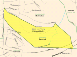 Census Bureau map of Tavistock, New Jersey | |
| Coordinates: 39°52′35″N 75°01′41″W / 39.876482°N 75.027979°WCoordinates: 39°52′35″N 75°01′41″W / 39.876482°N 75.027979°W[1][2] | |
| Country |
|
| State |
|
| County | Camden |
| Incorporated | February 16, 1921 |
| Government[3] | |
| • Type | Walsh Act |
| • Body | Board of Commissioners |
| • Mayor | John J. Aglialoro (term ends December 31, 2017)[4] |
| • Administrator / Clerk | Denise K. Moules[5] |
| Area[1] | |
| • Total | 0.257 sq mi (0.664 km2) |
| • Land | 0.254 sq mi (0.658 km2) |
| • Water | 0.003 sq mi (0.007 km2) 0.99% |
| Area rank |
557th of 566 in state 34th of 37 in county[1] |
| Elevation[6] | 46 ft (14 m) |
| Population (2010 Census)[7][8][9] | |
| • Total | 5 |
| • Estimate (2015)[10] | 5 |
| • Rank |
566th of 566 in state 37th of 37 in county[11] |
| • Density | 19.7/sq mi (7.6/km2) |
| • Density rank |
561st of 566 in state 36th of 37 in county[11] |
| Time zone | Eastern (EST) (UTC-5) |
| • Summer (DST) | Eastern (EDT) (UTC-4) |
| ZIP code | 08033 - Haddonfield[12] |
| Area code(s) | 856[13] |
| FIPS code | 3400772240[1][14][15] |
| GNIS feature ID | 0885416[1][16] |
| Website |
www |

Tavistock is a borough in Camden County, New Jersey, United States. As of the 2010 United States Census, the population was 5,[7][8][9] reflecting a decline of 19 (-79.2%) from the 24 counted in the 2000 Census, which had in turn declined by 11 (-31.4%) from the 35 counted in the 1990 Census.[17] As of the 2010 Census it was the smallest municipality by population in New Jersey, with seven fewer residents than nearby Pine Valley, which had 12.[18]
Tavistock was incorporated as a borough by an act of the New Jersey Legislature on February 16, 1921, from portions of the now-defunct Centre Township.[19] The name of the borough came from the estate in England of a family of early settlers.[20][21]
The borough was formed for the purpose of allowing the members of Tavistock Country Club the ability to play golf on Sundays. This was prohibited at the Haddon Country Club which was governed by a local blue law prohibiting sporting activities on Sundays.[22] Tavistock's secession from Haddonfield, New Jersey, the original site of the club, is said to have been driven by the fact that Haddonfield was (and remains) a dry borough, though Tavistock was formed in 1921 during Prohibition when liquor would have been banned.[23][24]
Geography
According to the United States Census Bureau, Tavistock borough had a total area of 0.257 square miles (0.664 km2), including 0.254 square miles (0.658 km2) of land and 0.003 square miles (0.007 km2) of water (0.99%).[1][2]
The borough borders Barrington, Haddonfield, and Lawnside.
Demographics
| Historical population | |||
|---|---|---|---|
| Census | Pop. | %± | |
| 1930 | 20 | — | |
| 1940 | 13 | −35.0% | |
| 1950 | 15 | 15.4% | |
| 1960 | 10 | −33.3% | |
| 1970 | 12 | 20.0% | |
| 1980 | 9 | −25.0% | |
| 1990 | 35 | 288.9% | |
| 2000 | 24 | −31.4% | |
| 2010 | 5 | −79.2% | |
| Est. 2015 | 5 | [10][25] | 0.0% |
| Population sources: 1930-2000[26] 1930[27] 1930-1990[28] 2000[29][30] 2010[7][8][9] | |||
Census 2010
The 2010 United States Census counted 5 people, 3 households, and 2.001 families residing in the borough. The population density was 19.7 per square mile (7.6/km2). The borough contained 3 housing units at an average density of 11.8 per square mile (4.6/km2). The racial makeup of the borough was 100.00% (5) White, 0.00% (0) Black or African American, 0.00% (0) Native American, 0.00% (0) Asian, 0.00% (0) Pacific Islander, 0.00% (0) from other races, and 0.00% (0) from two or more races. Hispanics or Latinos of any race were 0.00% (0) of the population.[7]
Out of a total of 3 households, 0.0% had children under the age of 18 living with them, 66.7% were married couples living together, 0.0% had a female householder with no husband present, and 33.3% were non-families. 33.3% of all households were made up of individuals, and 33.3% had someone living alone who was 65 years of age or older. The average household size was 1.67 and the average family size was 2.00.[7]
In the borough, 0.0% of the population were under the age of 18, 0.0% from 18 to 24, 40.0% from 25 to 44, 0.0% from 45 to 64, and 60.0% who were 65 years of age or older. The median age was 66.3 years. For every 100 females the census counted 150.0 males, but for 100 females at least 18 years old, it was 150.0 males.[7]
Due to the borough's population, the Census Bureau's 2006-2010 American Community Survey did not include information about income and poverty for residents.[31]
Census 2000
As of the 2000 United States Census[14] there were 24 people, 7 households, and 7 families residing in the borough. The population density was 94.3 people per square mile (37.1/km2). There were 7 housing units at an average density of 27.5 per square mile (10.8/km2). The racial makeup of the borough was 91.67% White and 8.33% African American.[29][30]
There were 7 households out of which 57.1% had children under the age of 18 living with them, 71.4% were married couples living together, 14.3% had a female householder with no husband present, and 0.0% were non-families. No households were made up of individuals and none had someone living alone who was 65 years of age or older. The average household size was 3.43 and the average family size was 3.43.[1]
In the borough the population was spread out with 37.5% under the age of 18, 8.3% from 18 to 24, 25.0% from 25 to 44, 20.8% from 45 to 64, and 8.3% who were 65 years of age or older. The median age was 38 years. For every 100 females there were 100.0 males. For every 100 females age 18 and over, there were 87.5 males.[1]
The median income for a household in the borough was $58,750, and the median income for a family was $36,875. Males had a median income of $76,250 versus $46,250 for females. The per capita income for the borough was $14,600. There are 20.0% of families living below the poverty line and 21.7% of the population, including 25.0% of under eighteens and none of those over 64.[1]
Government
Local government
Tavistock operates under the Walsh Act commission form of New Jersey municipal government. Three non-partisan commissioners are elected at-large to concurrent four-year terms of office. Each commissioner is assigned a specific department to head in addition to their legislative functions.[3] Tavistock has been governed under the Walsh Act by a three-member commission, since 1928.[32][33]
As of 2016, Tavistock's commissioners are Mayor John J. Aglialoro, Joan P. Carter and Joseph Del Duca, all serving concurrent terms of office ending December 31, 2017.[5][34][35]
Federal, state and county representation
Tavistock is located in the 1st Congressional District[36] and is part of New Jersey's 6th state legislative district.[8][37][38]
New Jersey's First Congressional District is represented by Donald Norcross (D, Camden).[39] New Jersey is represented in the United States Senate by Cory Booker (D, Newark, term ends 2021)[40] and Bob Menendez (D, Paramus, 2019).[41][42]
For the 2016–2017 session (Senate, General Assembly), the 6th Legislative District of the New Jersey Legislature is represented in the State Senate by James Beach (D, Voorhees Township) and in the General Assembly by Louis Greenwald (D, Voorhees Township) and Pamela Rosen Lampitt (D, Cherry Hill).[43] The Governor of New Jersey is Chris Christie (R, Mendham Township).[44] The Lieutenant Governor of New Jersey is Kim Guadagno (R, Monmouth Beach).[45]
Camden County is governed by a Board of Chosen Freeholders, whose seven members chosen at-large in partisan elections to three-year terms office on a staggered basis, with either two or three seats coming up for election each year.[46] As of 2015, Camden County's Freeholders are Freeholder Director Louis Cappelli, Jr. (Collingswood, term as freeholder ends December 31, 2017; term as director ends 2015),[47] Freeholder Deputy Director Edward T. McDonnell (Pennsauken Township, term as freeholder ends 2016; term as deputy director ends 2015),[48] Michelle Gentek (Gloucester Township, 2015),[49] Ian K. Leonard (Camden, 2015),[50] Jeffrey L. Nash (Cherry Hill, 2015),[51] Carmen Rodriguez (Merchantville, 2016)[52] and Jonathan L. Young, Sr. (Berlin Township, November 2015; serving the unexpired term of Scot McCray ending in 2017)[53][54][55]
Camden County's constitutional officers, all elected directly by voters, are County clerk Joseph Ripa,[56] Sheriff Charles H. Billingham,[57] and Surrogate Patricia Egan Jones.[55][58] The Camden County Prosecutor Mary Eva Colalillo was appointed by the Governor of New Jersey with the advice and consent of the New Jersey Senate (the upper house of the New Jersey Legislature).[59]
Politics
As of March 23, 2011, there were a total of seven registered voters in Tavistock, of which none were registered as Democrats, six (85.7%) were registered as Republicans and one (14.3%) was registered as Unaffiliated. There were no voters registered to other parties.[60]
In the 2012 presidential election, Republican Mitt Romney received 66.7% of the vote (2 cast), ahead of Democrat Barack Obama with 33.3% (1 vote), and other candidates receiving no votes, among the 3 ballots cast by the borough's 6 registered voters for a turnout of 50.0%.[61][62] In the 2008 presidential election, Republican John McCain received 71.4% of the vote (5 cast), ahead of Democrat Barack Obama, who received around 28.6% (2 votes), with 7 ballots cast among the borough's 7 registered voters, for a turnout of 100.0%.[63] In the 2004 presidential election, Republican George W. Bush received 88.9% of the vote (8 ballots cast), outpolling Democrat John Kerry, who received 11.1% (1 vote), with 9 ballots cast among the borough's 11 registered voters, for a turnout percentage of 81.8.[64]
In the 2013 gubernatorial election, Republican Chris Christie received 100.0% of the vote (1 cast), ahead of Democrat Barbara Buono and other candidates who received no votes, among the 4 ballots cast by the borough's 5 registered voters (3 ballots were spoiled), for a turnout of 80.0%.[65][66] In the 2009 gubernatorial election, Republican Chris Christie received 100.0% of the vote (5 ballots cast), ahead of both Democrat Jon Corzine and Independent Chris Daggett who received none, with 5 ballots cast among the borough's 7 registered voters, yielding a 71.4% turnout.[67]
Education
Tavistock is a non-operating school district.[68] School age students in Tavistock attend the Haddonfield Public Schools in the adjoining community of Haddonfield as part of a sending/receiving relationship.[24]
Transportation
Roads and highways
As of May 2010, the borough had a total of 0.17 miles (0.27 km) of roadways, all of which is maintained by the New Jersey Turnpike Authority.[69]
Interstate 295 passes through but the nearest interchange is immediately over the border in neighboring Haddonfield.[70] The New Jersey Turnpike runs briefly through Tavistock, although the nearest exit is for Bellmawr and Runnemede.[71]
Public transportation
New Jersey Transit local bus service is available on the 451 route between Camden and the Lindenwold train station.[72][73]
References
- 1 2 3 4 5 6 7 8 9 2010 Census Gazetteer Files: New Jersey County Subdivisions, United States Census Bureau. Accessed May 21, 2015.
- 1 2 US Gazetteer files: 2010, 2000, and 1990, United States Census Bureau. Accessed September 4, 2014.
- 1 2 2012 New Jersey Legislative District Data Book, Rutgers University Edward J. Bloustein School of Planning and Public Policy, March 2013, p. 33.
- ↑ 2016 New Jersey Mayors Directory, New Jersey Department of Community Affairs. Accessed June 14, 2016.
- 1 2 Home page, Borough of Tavistock. Accessed June 27, 2016.
- ↑ U.S. Geological Survey Geographic Names Information System: Borough of Tavistock, Geographic Names Information System. Accessed March 14, 2013.
- 1 2 3 4 5 6 DP-1 - Profile of General Population and Housing Characteristics: 2010 for Tavistock borough, Camden County, New Jersey, United States Census Bureau. Accessed October 12, 2012.
- 1 2 3 4 Municipalities Grouped by 2011-2020 Legislative Districts, New Jersey Department of State, p. 4. Accessed January 6, 2013.
- 1 2 3 Profile of General Demographic Characteristics: 2010 for Tavistock borough, New Jersey Department of Labor and Workforce Development. Accessed October 12, 2012.
- 1 2 PEPANNRES - Annual Estimates of the Resident Population: April 1, 2010 to July 1, 2015 - 2015 Population Estimates for New Jersey municipalities, United States Census Bureau. Accessed May 22, 2016.
- 1 2 GCT-PH1 Population, Housing Units, Area, and Density: 2010 - State -- County Subdivision from the 2010 Census Summary File 1 for New Jersey, United States Census Bureau. Accessed October 12, 2012.
- ↑ Look Up a ZIP Code for Tavistock, NJ, United States Postal Service. Accessed October 12, 2012.
- ↑ Area Code Lookup - NPA NXX for Tavistock, NJ, Area-Codes.com. Accessed November 6, 2013.
- 1 2 American FactFinder, United States Census Bureau. Accessed September 4, 2014.
- ↑ A Cure for the Common Codes: New Jersey, Missouri Census Data Center. Accessed October 12, 2012.
- ↑ US Board on Geographic Names, United States Geological Survey. Accessed September 4, 2014.
- ↑ Table 7. Population for the Counties and Municipalities in New Jersey: 1990, 2000 and 2010, New Jersey Department of Labor and Workforce Development, February 2011. Accessed October 12, 2012.
- ↑ Staff. "N.J.'s population shifting to coast, south", USA Today, February 27, 2011. Accessed October 28, 2014.
- ↑ Snyder, John P. The Story of New Jersey's Civil Boundaries: 1606-1968, Bureau of Geology and Topography; Trenton, New Jersey; 1969. p. 109. Accessed October 12, 2012.
- ↑ Hutchinson, Viola L. The Origin of New Jersey Place Names, New Jersey Public Library Commission, May 1945. Accessed October 11, 2015.
- ↑ Greenblatt, Sarah. "Tavistock: No golf on Sunday? Hah!", The Courier-Post, October 18, 2006. Accessed October 11, 2015. "1917: Two sons of the prominent Gill Hopkins family of Baltimore that established Johns Hopkins University inherit the property, which has by now become a summer home renamed Tavistock, in honor of a family estate in England."
- ↑ Rothschild, Barbara S. "Haddonfield: Quaker roots run deep", Courier-Post, October 19, 2006. Accessed June 25, 2008. "Another ban, in the form of blue laws, prohibited Sunday golfing, which led to the incorporation of Tavistock -- primarily a country club -- as a separate borough in 1921."
- ↑ Strauss, Robert. "Ready, Set, Get Ready", The New York Times, May 14, 2000. Accessed June 25, 2008. "Local legend has it that Tavistock, the club and the town (population 10), seceded from nearby Haddonfield in a dispute over whether the club could serve liquor in otherwise dry Quaker Haddonfield."
- 1 2 Staff. "No golf on Sunday? Ha! They fixed that fast", Courier-Post, May 4, 2008. Accessed June 25, 2008. "In their 1989 book, "Lost Haddonfield," the historians noted Tavistock was established in 1921, when Prohibition prevented alcohol from being sold anywhere legally.... The Haddonfield Public School District serves children who live in Tavistock."
- ↑ Census Estimates for New Jersey April 1, 2010 to July 1, 2015, United States Census Bureau. Accessed May 22, 2016.
- ↑ Barnett, Bob. Population Data for Camden County Municipalities, 1850 - 2000, WestJersey.org, January 6, 2011. Accessed October 12, 2012.
- ↑ Fifteenth Census of the United States: 1930 - Population Volume I, United States Census Bureau, p. 715. Accessed October 12, 2012.
- ↑ Table 6. New Jersey Resident Population by Municipality: 1930 - 1990, New Jersey Department of Labor and Workforce Development. Accessed June 28, 2015.
- 1 2 Census 2000 Profiles of Demographic / Social / Economic / Housing Characteristics for Tavistock borough, New Jersey, United States Census Bureau. Accessed October 12, 2012.
- 1 2 DP-1: Profile of General Demographic Characteristics: 2000 - Census 2000 Summary File 1 (SF 1) 100-Percent Data for Tavistock borough, Camden County, New Jersey, United States Census Bureau. Accessed October 12, 2012.
- ↑ DP03: Selected Economic Characteristics from the 2006-2010 American Community Survey 5-Year Estimates for Tavistock borough, Camden County, New Jersey, United States Census Bureau. Accessed October 12, 2012.
- ↑ "The Commission Form of Municipal Government", p. 53. Accessed June 3, 2015.
- ↑ "Forms of Municipal Government in New Jersey", p. 8. Rutgers University Center for Government Studies. Accessed June 3, 2015.
- ↑ 2016 Municipal User Friendly Budget, Borough of Tavistock. Accessed June 27, 2016.
- ↑ Official Election Results 2013 General Election November 5, 2013, Camden County, New Jersey, November 14, 2013. Accessed June 23, 2016.
- ↑ Plan Components Report, New Jersey Redistricting Commission, December 23, 2011. Accessed January 6, 2013.
- ↑ 2016 New Jersey Citizen's Guide to Government, p. 65, New Jersey League of Women Voters. Accessed July 20, 2016.
- ↑ Districts by Number for 2011-2020, New Jersey Legislature. Accessed January 6, 2013.
- ↑ Directory of Representatives: New Jersey, United States House of Representatives. Accessed January 5, 2012.
- ↑ About Cory Booker, United States Senate. Accessed January 26, 2015. "He now owns a home and lives in Newark's Central Ward community."
- ↑ Biography of Bob Menendez, United States Senate, January 26, 2015. "He currently lives in Paramus and has two children, Alicia and Robert."
- ↑ Senators of the 114th Congress from New Jersey. United States Senate. Accessed January 26, 2015. "Booker, Cory A. - (D - NJ) Class II; Menendez, Robert - (D - NJ) Class I"
- ↑ Legislative Roster 2016-2017 Session, New Jersey Legislature. Accessed January 17, 2016.
- ↑ "About the Governor". State of New Jersey. Retrieved 2010-01-21.
- ↑ "About the Lieutenant Governor". State of New Jersey. Retrieved 2010-01-21.
- ↑ What is a Freeholder?, Camden County, New Jersey. Accessed May 12, 2015.
- ↑ Freeholder Louis Cappelli, Jr., Camden County, New Jersey. Accessed May 12, 2015.
- ↑ Freeholder Edward T. McDonnell, Camden County, New Jersey. Accessed May 12, 2015.
- ↑ Freeholder Michelle Gentek, Camden County, New Jersey. Accessed May 12, 2015.
- ↑ Freeholder Ian K. Leonard, Camden County, New Jersey. Accessed May 12, 2015.
- ↑ Freeholder Jeffrey L. Nash, Camden County, New Jersey. Accessed May 12, 2015.
- ↑ Freeholder Carmen Rodriguez, Camden County, New Jersey. Accessed May 12, 2015.
- ↑ Jonathan L. Young, Sr., Camden County, New Jersey. Accessed May 12, 2015.
- ↑ Daniels, Mark. "Carpenters union official tapped for Camden County Freeholder seat", South Jersey Times, January 22, 2015. Accessed May 12, 2015. "Democratic leaders in Camden County have nominated a construction union official from Berlin Township to fill an open seat on the board of chosen freeholders. Jonathan L. Young Sr., 45, has been nominated to replace Scot McCray, who resigned from the board in late December, citing a desire to spend more time with his family."
- 1 2 Board of Freeholders, Camden County, New Jersey. Accessed May 12, 2015.
- ↑ County Clerk, Camden County, New Jersey. Accessed May 12, 2015.
- ↑ Sheriff, Camden County, New Jersey. Accessed May 12, 2015.
- ↑ Surrogate's Office, Camden County, New Jersey. Accessed May 12, 2015.
- ↑ Prosecutor's Office, Camden County, New Jersey. Accessed May 12, 2015.
- ↑ Voter Registration Summary - Camden, New Jersey Department of State Division of Elections, March 23, 2011. Accessed October 15, 2012.
- ↑ "Presidential General Election Results - November 6, 2012 - Camden County" (PDF). New Jersey Department of Elections. March 15, 2013. Retrieved December 24, 2014.
- ↑ "Number of Registered Voters and Ballots Cast - November 6, 2012 - General Election Results - Camden County" (PDF). New Jersey Department of Elections. March 15, 2013. Retrieved December 24, 2014.
- ↑ 2008 Presidential General Election Results: Camden County, New Jersey Department of State Division of Elections, December 23, 2008. Accessed October 15, 2012.
- ↑ 2004 Presidential Election: Camden County, New Jersey Department of State Division of Elections, December 13, 2004. Accessed October 15, 2012.
- ↑ "Governor - Camden County" (PDF). New Jersey Department of Elections. January 29, 2014. Retrieved December 24, 2014.
- ↑ "Number of Registered Voters and Ballots Cast - November 5, 2013 - General Election Results - Camden County" (PDF). New Jersey Department of Elections. January 29, 2014. Retrieved December 24, 2014.
- ↑ 2009 Governor: Camden County, New Jersey Department of State Division of Elections, December 31, 2009. Accessed October 15, 2012.
- ↑ 13 Non-Operating School Districts Eliminated, New Jersey Department of Education press release dated July 1, 2009. Accessed December 26, 2009.
- ↑ Camden County Mileage by Municipality and Jurisdiction, New Jersey Department of Transportation, May 2010. Accessed November 6, 2013.
- ↑ Interstate 295 Straight Line Diagram, New Jersey Department of Transportation, February 2008. Accessed November 6, 2013.
- ↑ New Jersey Turnpike Straight Line Diagram, New Jersey Department of Transportation, January 1997. Accessed November 6, 2013. Both the Census Bureau map above and one provided by Google Maps shows the Turnpike passing through the southeast corner of the borough, but this is not shown in the diagram here.
- ↑ Camden County Bus / Rail Connections, New Jersey Transit, backed up by the Internet Archive as of May 22, 2009. Accessed October 12, 2012.
- ↑ South Jersey Transit Guide, Cross County Connection, as of April 1, 2010. Accessed October 28, 2014.
External links
- Official website
- Haddonfield Public Schools
- Haddonfield Public Schools's 2014–15 School Report Card from the New Jersey Department of Education
- School Data for the Haddonfield Public Schools, National Center for Education Statistics
- Tavistock Country Club
Municipalities and communities of Camden County, New Jersey, United States | ||
|---|---|---|
| Cities | 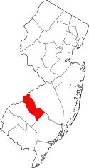 | |
| Boroughs | ||
| Townships | ||
| CDPs | ||
| Other unincorporated communities | ||