Tatworth
| Tatworth | |
 St John's Church |
|
 Tatworth |
|
| Population | 2,660 (2011)[1] |
|---|---|
| OS grid reference | ST325055 |
| Civil parish | Chard |
| District | South Somerset |
| Shire county | Somerset |
| Region | South West |
| Country | England |
| Sovereign state | United Kingdom |
| Post town | CHARD |
| Postcode district | TA20 |
| Dialling code | 01460 |
| Police | Avon and Somerset |
| Fire | Devon and Somerset |
| Ambulance | South Western |
| EU Parliament | South West England |
| UK Parliament | Yeovil |
Coordinates: 50°50′42″N 2°57′36″W / 50.8450°N 2.9601°W
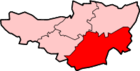
Tatworth is a village 2 miles (3 km) south of Chard in the South Somerset district of the county of Somerset, England. It is part of the Tatworth and Forton civil parish and the electoral ward of the same name.
Tatworth is a large village, consisting of a number of smaller villages including South Chard, Perry Street and Chard Junction which are close together.
Tatworth has a primary school, two pubs: Ye Olde Poppe Inn, the Golden Fleece and the Perry Street Club, a members-only club. It also has a McColl's shop which is also a post office.
History
A white lias limestone Roman tessera measuring 25.7 millimetres (1.01 in) x 20.18 millimetres (0.79 in) x 17.75 millimetres (0.70 in) and regularly cut on two faces was found in the area,[2] and may be connected with the remains of a Roman villa or farmhouse by St Margaret's Lane. Part of this building was excavated in 1967 and pottery and paving found there are displayed in the Chard Museum.[3]
The name of the village comes from the Old English tat and worp meaning 'A cheerful farm'.[4] In 1254, the spelling was Tattewurthe and was a sub-manor of Chard.[5] In 1554 Thatteworh was granted to William Petre as the 'manor and park of Tatworthy' and remained in the family until 1790. Tatworth in the 1850s extended to 1,552 acres (6.28 km2) and had a population of 852.[5]
Governance
The parish council has responsibility for local issues, including setting an annual precept (local rate) to cover the council’s operating costs and producing annual accounts for public scrutiny. The parish council evaluates local planning applications and works with the local police, district council officers, and neighbourhood watch groups on matters of crime, security, and traffic. The parish council's role also includes initiating projects for the maintenance and repair of parish facilities, as well as consulting with the district council on the maintenance, repair, and improvement of highways, drainage, footpaths, public transport, and street cleaning. Conservation matters (including trees and listed buildings) and environmental issues are also the responsibility of the council.
The village falls within the Non-metropolitan district of South Somerset, which was formed on 1 April 1974 under the Local Government Act 1972, having previously been part of Chard Rural District.[6] The district council is responsible for local planning and building control, local roads, council housing, environmental health, markets and fairs, refuse collection and recycling, cemeteries and crematoria, leisure services, parks, and tourism.
Somerset County Council is responsible for running the largest and most expensive local services such as education, social services, libraries, main roads, public transport, policing and fire services, trading standards, waste disposal and strategic planning.
It is also part of the Yeovil county constituency represented in the House of Commons of the Parliament of the United Kingdom. It elects one Member of Parliament (MP) by the first past the post system of election, and part of the South West England constituency of the European Parliament which elects seven MEPs using the d'Hondt method of party-list proportional representation.
Geography
Stowell Meadow is a biological Site of Special Scientific Interest.
Religious sites
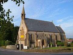
St John's Church, which dates from 1851, is designated by English Heritage as a Grade II listed building.[7][8]
Sport

Tatworth has a number of local sports clubs. The Perry Street & District Football League was formed in Tatworth in 1903 by Charles Edward Small, the owner of the Perry Street Lace Works.[9] Perry Street Football Club still play in the league today. There is also a cricket club and local skittles league based at Perry Street Club.[10]
References
- ↑ "Statistics for Wards, LSOAs and Parishes — SUMMARY Profiles" (Excel). Somerset Intelligence. Retrieved 4 January 2014.
- ↑ "Tessera". Portable Antiquities Scheme. Retrieved 2007-11-23.
- ↑ "The Story of Tatworth & Forton, briefly told". Retrieved 2007-11-23.
- ↑ Robinson, Stephen (1992). Somerset Place Names. Wimborne, Dorset: Dovecote Press. ISBN 1-874336-03-2.
- 1 2 "Chapter 5" (PDF). Open Windows Learning. Retrieved 8 December 2010.
- ↑ "Chard RD". A vision of Britain Through Time. University of Portsmouth. Retrieved 4 January 2014.
- ↑ "Church of St John, Tatworth". Somerset Historic Environment Record. Retrieved 2007-11-23.
- ↑ "Church of St John". Images of England. Retrieved 2007-11-23.
- ↑ "Perry Street & District League". TheFA.com. Retrieved 8 May 2012.
- ↑ "Perry Street Skittles League". Yeovil Express. Retrieved 8 May 2012.
External links
| Wikimedia Commons has media related to Tatworth. |