Tatoosh Island, Washington
|
The island from the air. | |
| Geography | |
|---|---|
| Location | Makah Reservation, Clallam County, Washington, United States |
| Coordinates | 48°23′31″N 124°44′06″W / 48.392°N 124.735°WCoordinates: 48°23′31″N 124°44′06″W / 48.392°N 124.735°W |
| Administration | |
| State | Washington |
| County | Clallam County |

|
Tatoosh Island | |
|
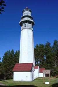
Cape Flattery Light from offshore | |
| Location | Olympic Peninsula, Washington |
|---|---|
| Built | 1857 |
| Architect | US Coast Guard |
| NRHP Reference # | 72001267 [1] |
| Added to NRHP | March 16, 1972 |

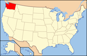
Tatoosh Island is a small island and small group of islands about 0.5 miles (0.8 km) offshore (northwest) of Cape Flattery, which is on the northwestern tip of the Olympic Peninsula in Washington. Tatoosh is the largest of a small group of islands also often referred to as simply "Tatoosh Island", which are almost as far west as Cape Alava, about 15 miles (24 km) to the south and the westernmost point in the contiguous 48 states. The islands are part of the Makah Reservation and a part of Clallam County. The total land area of the island group is 159,807 square metres (1,720,150 square feet).
Historically, Tatoosh Island was inhabited seasonally by Makah fishing camps and employees of the United States Coast Guard, Weather Bureau, and Navy. Currently there is no resident population on the islands. Access to the island requires written permission of the Makah tribe. The island's name comes from a Makah chief known as Tatoosh[2] (also Tatooche or Tetacus).
Tatoosh Island has been home to Cape Flattery Light, which overlooks the entrance to the Strait of Juan de Fuca, since December 28, 1857.[3]
Ecology
Because of its isolation, climate, and location in the productive northeastern Pacific Ocean, Tatoosh Island is home to many nesting seabirds, several marine mammals, and a diverse community of marine plants and animals. Beginning in 1967, Professor Robert T. Paine of the University of Washington and his colleagues have undertaken detailed studies of marine ecology on the island. Consequently, it is now one of the most intensively studied field sites in the world.

The research has revealed how species are linked to each other through a network of species interactions, and how environmental changes and species extinction are transmitted through the food web. Key ecological concepts explored by this research include keystone species, control by consumers and natural disturbances on ecosystem structure and spatial patterning, species interaction strength, body size-dependent population dynamics, and impacts of environmental changes such as ocean acidification and El Niño events on complex ecosystems.
Climate
| Climate data for Tatoosh, Washington | |||||||||||||
|---|---|---|---|---|---|---|---|---|---|---|---|---|---|
| Month | Jan | Feb | Mar | Apr | May | Jun | Jul | Aug | Sep | Oct | Nov | Dec | Year |
| Record high °F (°C) | 64 (18) |
64 (18) |
67 (19) |
75 (24) |
81 (27) |
82 (28) |
80 (27) |
78 (26) |
80 (27) |
77 (25) |
68 (20) |
61 (16) |
82 (28) |
| Average high °F (°C) | 45.3 (7.4) |
46.8 (8.2) |
48.0 (8.9) |
51.5 (10.8) |
55.0 (12.8) |
57.7 (14.3) |
59.5 (15.3) |
59.8 (15.4) |
59.1 (15.1) |
55.8 (13.2) |
50.7 (10.4) |
47.5 (8.6) |
53.1 (11.7) |
| Daily mean °F (°C) | 42.0 (5.6) |
43.2 (6.2) |
44.1 (6.7) |
47.3 (8.5) |
50.8 (10.4) |
53.7 (12.1) |
55.5 (13.1) |
55.8 (13.2) |
54.7 (12.6) |
51.9 (11.1) |
47.2 (8.4) |
44.2 (6.8) |
49.2 (9.56) |
| Average low °F (°C) | 38.7 (3.7) |
39.6 (4.2) |
40.2 (4.6) |
43.2 (6.2) |
46.7 (8.2) |
49.8 (9.9) |
51.5 (10.8) |
51.8 (11) |
50.3 (10.2) |
48.0 (8.9) |
43.6 (6.4) |
40.9 (4.9) |
45.4 (7.4) |
| Record low °F (°C) | 14 (−10) |
20 (−7) |
25 (−4) |
33 (1) |
37 (3) |
43 (6) |
45 (7) |
45 (7) |
43 (6) |
33 (1) |
19 (−7) |
14 (−10) |
14 (−10) |
| Average precipitation inches (mm) | 10.58 (268.7) |
8.91 (226.3) |
8.12 (206.2) |
5.28 (134.1) |
2.96 (75.2) |
2.71 (68.8) |
2.29 (58.2) |
2.06 (52.3) |
3.49 (88.6) |
8.34 (211.8) |
10.69 (271.5) |
12.15 (308.6) |
77.55 (1,969.8) |
| Average snowfall inches (cm) | 3.5 (8.9) |
1.6 (4.1) |
1.7 (4.3) |
0 (0) |
0 (0) |
0 (0) |
0 (0) |
0 (0) |
0 (0) |
0 (0) |
0.4 (1) |
1.6 (4.1) |
8.8 (22.4) |
| Average precipitation days (≥ 0.01 in) | 22 | 19 | 20 | 17 | 13 | 13 | 11 | 12 | 11 | 17 | 21 | 24 | 199 |
| Source: WRCC (normals 1931–1966)[4] | |||||||||||||
Notes
- ↑ National Park Service (2007-01-23). "National Register Information System". National Register of Historic Places. National Park Service.
- ↑ Elyea, Winifred. 1929. "History of Tatoosh Island" Washington Historical Quarterly, 1929, Vol. 20, No. 3, p. 223-227, Washington University State Historical Society, retrieved 9 April 2013
- ↑ Cape Flattery Light on Tatoosh Island begins operating on December 28, 1857, HistoryLink.org
- ↑ "General Climate Summary Tables". Western Regional Climate Center. Retrieved November 25, 2012.
References
- Tatoosh Island group: Blocks 2046 and 2047, Census Tract 9801, Clallam County, Washington United States Census Bureau
- Paine, R. T. 1994. Marine Rocky Shores and Community Ecology: An Experimentalist's Perspective. Ecology Institute, Oldendorf/Luhe, Germany.
External links
- Photos and other items about Tatoosh Island from the Library of Congress
- History of Tatoosh Island from the University of Washington Libraries Digital Collections website
- Station TTIW1 - Tatoosh Island, WA from the National Data Buoy Center of the NOAA, with "sector pictures"
- Maps including Tatoosh Island, from the official Makah website
- Cape Flattery Tribal Scenic Byway from the Washington State Tourism website
- Photos of Cape Flattery Lighthouse and Helipad, from a commercial photographer's website
- Cape Flattery Lighthouse
- University of Washington Libraries Digital Collections – Makah Cultural and Research Center Online Museum Exhibit History and culture of the Makah tribe; includes images from Tatoosh Island.
- Research summaries, scientific articles, photographs of Tatoosh Island and its organisms, and a video interview of ecologists Cathy Pfister and Tim Wootton