Targassonne
| Targassonne Targasona | |
|---|---|
|
| |
 Targassonne | |
|
Location within Occitanie region  Targassonne | |
| Coordinates: 42°30′01″N 1°59′52″E / 42.5003°N 1.9978°ECoordinates: 42°30′01″N 1°59′52″E / 42.5003°N 1.9978°E | |
| Country | France |
| Region | Occitanie |
| Department | Pyrénées-Orientales |
| Arrondissement | Prades |
| Canton | Saillagouse |
| Intercommunality | Pyrénées Cerdagne |
| Government | |
| • Mayor | Jean-Pierre Will |
| Area1 | 7.80 km2 (3.01 sq mi) |
| Population (2007)2 | 200 |
| • Density | 26/km2 (66/sq mi) |
| Time zone | CET (UTC+1) |
| • Summer (DST) | CEST (UTC+2) |
| INSEE/Postal code | 66202 / 66120 |
| Elevation |
1,383–2,123 m (4,537–6,965 ft) (avg. 1,597 m or 5,240 ft) |
|
1 French Land Register data, which excludes lakes, ponds, glaciers > 1 km² (0.386 sq mi or 247 acres) and river estuaries. 2 Population without double counting: residents of multiple communes (e.g., students and military personnel) only counted once. | |

Hiking Trail near Targassonne.
Targassonne (in Catalan Targasona) is a commune of Cerdanya in the Pyrénées-Orientales department in south of France.
The town council and some maps use the name Targasonne.
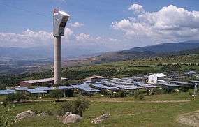
Targassonne is the home of the THEMIS Solar Power R&D Center.
Geography
Targassonne is located in the canton of Saillagouse and in the arrondissement of Prades. It is located at 1,600 meters near the villages of Égat and Font-Romeu-Odeillo-Via. The closest cities are Foix in the North-West at 61 kilometres and Perpignan at 90 kilometres to the East.

Map of Targassonne and its surrounding communes
Population
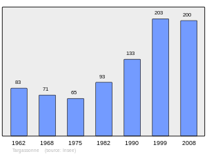
Population 1962-2008
See also
- Communes of the Pyrénées-Orientales department
- THEMIS Solar Power R&D Center
- Solar furnace in Odeillo
- Cerdanya
References
| Wikimedia Commons has media related to Targassonne. |
This article is issued from Wikipedia - version of the 3/15/2016. The text is available under the Creative Commons Attribution/Share Alike but additional terms may apply for the media files.