Tarcoola, South Australia
| Tarcoola South Australia | |||||||||||||
|---|---|---|---|---|---|---|---|---|---|---|---|---|---|
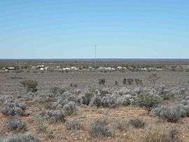 Tarcoola, South Australia, 2012. | |||||||||||||
 Tarcoola | |||||||||||||
| Coordinates | 30°42′S 134°34′E / 30.700°S 134.567°ECoordinates: 30°42′S 134°34′E / 30.700°S 134.567°E | ||||||||||||
| Population | 38 (2006 census)[1] | ||||||||||||
| Established | 1901[2] | ||||||||||||
| Postcode(s) | 5710[3] | ||||||||||||
| Elevation | 204 m (669 ft) | ||||||||||||
| Time zone | ACST (UTC+9:30) | ||||||||||||
| • Summer (DST) | ACST (UTC+10:30) | ||||||||||||
| Location |
| ||||||||||||
| LGA(s) | Unincorporated area | ||||||||||||
| State electorate(s) | Giles[4] | ||||||||||||
| Federal Division(s) | Grey[5] | ||||||||||||
| |||||||||||||
| |||||||||||||
| Footnotes |
Climate[6] Adjoining localities[2] | ||||||||||||
Tarcoola is a town in the Far North of South Australia 416 kilometres (258 mi) north-northwest of Port Augusta. At the 2006 census, the Tarcoola district had a population of 38.[1]
Tarcoola is taken from a non-local aboriginal language from an area around Tarcoola Station in New South Wales; it means river bend.
History
The Tarcoola Goldfield was discovered in 1893, but it was in an isolated arid area, and there was little development until 1900. A Post Office opened on 18 August 1900 and the town was proclaimed on 21 February 1901.[7] It was named after Tarcoola the winner of the 1893 Melbourne Cup horse race. The horse Tarcoola had been raised on Tarcoola Station on the Darling River.
The goldfield's heyday was from about 1901 to 1918. A government battery was built to process ore from small mines. Between 1901 and 1954 the field produced about 77,000oz (2.4 tonnes) of gold, most of it from the Tarcoola Blocks mine.[8]
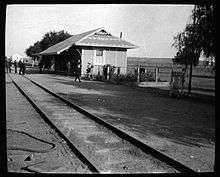
The Trans-Australian Railway was built through Tarcoola in 1915, and in 2004 the Adelaide–Darwin railway diverged from Tarcoola to Darwin.
The town is almost completely deserted today except for transient railway maintenance staff and geological exploration teams. The original Tarcoola goldfields are long closed. However, there is now new exploration for minerals in the wider area, including the Challenger Mine.
The Tarcoola Goldfield, Battery and Township is listed on the South Australian Heritage Register as a designated place of archaeological significance.[9]
Transport
Rail
Tarcoola is now best known as a junction of the Sydney-Perth and Adelaide-Darwin railways, which share the same approximately 530 kilometres (329 mi) of track between Tarcoola and Crystal Brook. There is a triangular junction at Tarcoola which joins Crystal Brook, Darwin and Perth. Another triangular junction at Crystal Brook joins Tarcoola, Adelaide and Sydney.
The Ghan and the Indian Pacific passenger services through Tarcoola both run once per week in each direction all year round, and twice per week at various times.[10][11] The mail for Tarcoola arrives by train.
Governance
Tarcoola is located within the federal division of Grey, the state electoral district of Giles and the unincorporated area of South Australia.[5][4][2]
Climate
Tarcoola has a desert climate with hot, dry summers and mild winters and sparse rainfall throughout the year.
| Climate data for Tarcoola Airport | |||||||||||||
|---|---|---|---|---|---|---|---|---|---|---|---|---|---|
| Month | Jan | Feb | Mar | Apr | May | Jun | Jul | Aug | Sep | Oct | Nov | Dec | Year |
| Record high °C (°F) | 48.9 (120) |
47.4 (117.3) |
43.0 (109.4) |
39.5 (103.1) |
32.0 (89.6) |
28.7 (83.7) |
28.0 (82.4) |
33.5 (92.3) |
39.0 (102.2) |
42.9 (109.2) |
46.5 (115.7) |
47.0 (116.6) |
48.9 (120) |
| Average high °C (°F) | 36.9 (98.4) |
35.1 (95.2) |
31.4 (88.5) |
27.2 (81) |
22.5 (72.5) |
18.8 (65.8) |
18.8 (65.8) |
21.2 (70.2) |
25.3 (77.5) |
27.9 (82.2) |
31.6 (88.9) |
33.8 (92.8) |
27.5 (81.5) |
| Average low °C (°F) | 19.7 (67.5) |
19.3 (66.7) |
16.1 (61) |
12.1 (53.8) |
8.2 (46.8) |
5.1 (41.2) |
4.6 (40.3) |
5.5 (41.9) |
9.0 (48.2) |
11.7 (53.1) |
15.6 (60.1) |
17.4 (63.3) |
12.0 (53.6) |
| Record low °C (°F) | 5.6 (42.1) |
10.0 (50) |
6.1 (43) |
1.3 (34.3) |
0.0 (32) |
−3.8 (25.2) |
−2.7 (27.1) |
−3.1 (26.4) |
0.5 (32.9) |
1.0 (33.8) |
5.0 (41) |
8.4 (47.1) |
−3.8 (25.2) |
| Average precipitation mm (inches) | 11.6 (0.457) |
26.4 (1.039) |
15.0 (0.591) |
10.2 (0.402) |
11.4 (0.449) |
13.5 (0.531) |
12.9 (0.508) |
11.4 (0.449) |
9.8 (0.386) |
16.8 (0.661) |
18.8 (0.74) |
22.4 (0.882) |
181.0 (7.126) |
| Source: [6] | |||||||||||||
References
| Wikivoyage has a travel guide for Tarcoola. |
- 1 2 Australian Bureau of Statistics (25 October 2007). "Tarcoola (State Suburb)". 2006 Census QuickStats. Retrieved 18 June 2012.
- 1 2 3 "Search result for "Tarcoola (Locality Bounded)" (Record no SA0065485) with the following layers selected - "Suburbs and Localities"". Property Location Browser. Department of Planning, Transport and Infrastructure. Retrieved 19 May 2016.
- ↑ "Postcode for Tarcoola, South Australia". postcodes-australia.com. Retrieved 19 May 2016.
- 1 2 "District of Giles Background Profile". Electoral Commission SA. Retrieved 14 May 2016.
- 1 2 "Federal electoral division of Grey" (PDF). Australian Electoral Commission. Retrieved 24 July 2015.
- 1 2 "Climate statistics for Tarcoola Aero". Bureau of Meteorology. Retrieved 3 April 2014.
- ↑ Premier Postal History. "Post Office List". Premier Postal Auctions. Retrieved 2011-05-26.
- ↑ J.F. Drexel, Mining in South Australia: a Pictorial History (Department of Mines & Energy, Adelaide, 1982, p. 129)
- ↑ "Tarcoola Goldfield, Government Battery and Township (designated place of archaeological significance)". South Australian Heritage Register. Department of Environment, Water and Natural Resources. Retrieved 12 February 2016.
- ↑ http://www.greatsouthernrail.com.au/site/indian_pacific/timetables_schedules.jsp
- ↑ http://www.greatsouthernrail.com.au/site/the_ghan/timetables_schedules.jsp