Tandel
| Tandel Tandel | ||
|---|---|---|
| Commune | ||
 | ||
| ||
 Map of Luxembourg with Tandel highlighted in orange, and the canton in dark red | ||
| Coordinates: 49°54′00″N 6°11′00″E / 49.9°N 6.1833°ECoordinates: 49°54′00″N 6°11′00″E / 49.9°N 6.1833°E | ||
| Country |
| |
| Canton | Vianden | |
| Government | ||
| • Mayor | Ali Kaes | |
| Area | ||
| • Total | 41.72 km2 (16.11 sq mi) | |
| Area rank | 10 of 105 | |
| Highest elevation | 537 m (1,762 ft) | |
| • Rank | 7th of 105 | |
| Lowest elevation | 190 m (620 ft) | |
| • Rank | 22nd of 105 | |
| Population (2014) | ||
| • Total | 1,819 | |
| • Rank | 74th of 105 | |
| • Density | 44/km2 (110/sq mi) | |
| • Density rank | 97th of 105 | |
| Time zone | CET (UTC+1) | |
| • Summer (DST) | CEST (UTC+2) | |
| LAU 2 | LU00004001 | |
| Website | tandel.lu | |

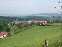
Tandel is a commune and village in eastern Luxembourg, in the canton of Vianden. It lies close to the border with Germany. As of 2001, the village of Tandel, which lies in the centre of the commune, has a population of 87. Other villages within the commune include Bastendorf, Bettel, Brandenbourg, Fouhren and Longsdorf.
The commune of Tandel was formed on 1 January 2006 from the former communes of Bastendorf (in the canton of Diekirch) and Fouhren (in the canton of Vianden). The law creating Tandel was passed on 21 December 2004.[1]
References
- ↑ "Mémorial A, 2004, No. 216" (PDF) (in French). Service central de législation. Retrieved 2006-08-15.
External links
-
 Media related to Tandel at Wikimedia Commons
 |
Putscheid, Vianden | | ||
| Bourscheid | |
Roth an der Our (DE-RP) Gentingen (DE-RP) | ||
| ||||
| | ||||
| Erpeldange | Diekirch, Bettendorf | Reisdorf |

This article is issued from Wikipedia - version of the 12/1/2016. The text is available under the Creative Commons Attribution/Share Alike but additional terms may apply for the media files.