Tana River (Kenya)
| Tana | |
|---|---|
 | |
| Basin | |
| River mouth |
into Indian Ocean 2°35′56″S 40°20′19″E / 2.599006°S 40.338621°ECoordinates: 2°35′56″S 40°20′19″E / 2.599006°S 40.338621°E |
| Physical characteristics | |
| Length | 800 km (500 mi) |
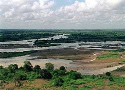
The 1,000 kilometres (620 mi) long Tana River is the longest river in Kenya, and gives its name to the Tana River County.[1] Its tributaries include the Thika, as well as several smaller rivers that flow only during the rainy season. The river rises in the Aberdare Mountains to the west of Nyeri. Initially it runs east before turning south around the massif of Mount Kenya. The river then runs into the Masinga Reservoir and Kiambere Reservoir, created by the Kindaruma dam. Below the dam the river turns north and flows along the north-south boundary between the Meru and North Kitui and Bisanadi, Kora and Rabole National Reserves. In the reserves the river turns east, and then south east. It passes through the towns of Garissa, Hola and Garsen before entering the Indian Ocean at Ungwana Bay-Kipini area, at the end of a river delta that reaches roughly 30 km upstream from the river mouth itself.[1]
Annual flow is above 5,000 million cubic meters (MCM) on average, but varies substantially both within and across years, and includes two flood seasons each year. Between 1944 and 1978, average total flow (at Garissa) was 6,105 MCM, varying from only 1,789 MCM in 1949 to 13,342 MCM in 1968.[2] During the 1982-1996 period, annual flow remained above 5,000 MCM as well.[3] A series of hydroelectric dams have been constructed along the river, including the Kindaruma Dam in 1968, the Kamburu Dam in 1975, the Gitaru Dam in 1978, the Masinga Dam in 1981, and the Kiambere Dam in 1988.[4][5] A 2003 study reported that two-thirds of Kenya's electrical needs were supplied by the series of dams along the Tana River.[6]
Water is drawn from the river by the following major irrigation projects: Bura Irrigation and Settlement Project, Tana Irrigation Scheme and the Tana Delta Irrigation Project.[7]
See also
References
- 1 2 Nakaegawa T., Wachana C. and KAKUSHIN Team-3 Modeling Group. (2012). "First impact assessment of hydrological cycle in the Tana River Basin, Kenya, under a changing climate in the late 21st Century," Hydrological Research Letters, 6, pp. 29-34.
- ↑ Hughes, F. (1990). "The Influence of Flooding Regimes on Forest Distribution and Composition in the Tana River Floodplain, Kenya," Journal of Applied Ecology, 27(2), pp. 475-491.
- ↑ Maingi, J.K. and Marsh, S.E. (2002). "Quantifying hydrologic impacts following dam construction along the Tana River, Kenya," Journal of Arid Environments, 50, pp. 53-79.
- ↑ Adams, W. M. and Hughes, F. M. R. (1986). "The Environmental Effects of Dam Construction in Tropical Africa: Impacts and Planning Procedures," Geoforum, 17(3), pp. 403-410.
- ↑ Galadin, H., Bidault, N., Stephen, L., Watkins, B., Dilley, M., and Mutunga, N. (2006). "Reducing the Impacts of Floods through Early Warning and Preparedness: A Pilot Study for Kenya" (PDF). Arnold, Chen, Deichmann, Dilley, Lerner-Lam, Pullen, and Trohanis. Natural Disaster Hotspots Case Studies. The World Bank. Retrieved 2012-06-23.
- ↑ "Tana River, Kenya: integrating downstream values into hydropower planning" (PDF). Case Studies in Wetland Valuation #6. International Union for Conservation of Nature. May 2003. Retrieved 2012-06-24.
- ↑ Government of Kenya 2007. Kenya Vision 2030: a Globally Competitive and Prosperous Kenya.
External links
| Wikimedia Commons has media related to Tana River (Kenya). |