Taisnières-en-Thiérache
| Taisnières-en-Thiérache | ||
|---|---|---|
| ||
 Taisnières-en-Thiérache | ||
|
Location within Hauts-de-France region  Taisnières-en-Thiérache | ||
| Coordinates: 50°08′48″N 3°48′51″E / 50.1467°N 3.8142°ECoordinates: 50°08′48″N 3°48′51″E / 50.1467°N 3.8142°E | ||
| Country | France | |
| Region | Hauts-de-France | |
| Department | Nord | |
| Arrondissement | Avesnes-sur-Helpe | |
| Canton | Avesnes-sur-Helpe-Nord | |
| Intercommunality | Deux Helpes | |
| Government | ||
| • Mayor (2008–2014) | Claude Connart | |
| Area1 | 8.5 km2 (3.3 sq mi) | |
| Population (1999)2 | 497 | |
| • Density | 58/km2 (150/sq mi) | |
| Time zone | CET (UTC+1) | |
| • Summer (DST) | CEST (UTC+2) | |
| INSEE/Postal code | 59583 / 59550 | |
| Elevation |
131–191 m (430–627 ft) (avg. 140 m or 460 ft) | |
|
1 French Land Register data, which excludes lakes, ponds, glaciers > 1 km² (0.386 sq mi or 247 acres) and river estuaries. 2 Population without double counting: residents of multiple communes (e.g., students and military personnel) only counted once. | ||
Taisnières-en-Thiérache is a commune in the Nord department in northern France.
Heraldry
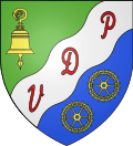 |
The arms of Taisnières-en-Thiérache are blazoned : Per bend sinister vert and azure, on a bend sinister wavy argent between a bell tranfixed by a crozier and in base 2 wheels Or, the letters P,D and V gules. |
See also
References
| Wikimedia Commons has media related to Taisnières-en-Thiérache. |
This article is issued from Wikipedia - version of the 11/26/2014. The text is available under the Creative Commons Attribution/Share Alike but additional terms may apply for the media files.