Tai Tam Reservoirs
| Tai Tam Reservoirs | |
|---|---|
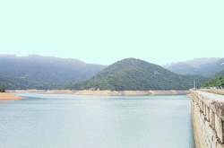 photograph taken from the main dam | |
| Location | Hong Kong |
| Coordinates | 22°16′N 114°13′E / 22.26°N 114.21°ECoordinates: 22°16′N 114°13′E / 22.26°N 114.21°E |
| Lake type | reservoir |
The Tai Tam Reservoirs (Chinese: 大潭水塘), also known as Tai Tam Reservoir Group, is a group of reservoirs located in the Tai Tam Country Park in the eastern part of Hong Kong Island in Hong Kong.
The reservoirs consist of:
- Tai Tam Upper Reservoir (大潭上水塘), 22°15′36″N 114°12′36″E / 22.260°N 114.210°E
- Tai Tam Byewash Reservoir (大潭副水塘),
- Tai Tam Intermediate Reservoir (大潭中水塘) 22°14′46″N 114°12′36″E / 22.246°N 114.210°E and
- Tai Tam Tuk Reservoir (大潭篤水塘) 22°14′35″N 114°13′12″E / 22.243°N 114.220°E.
The upper and byewash reservoirs are joinly known as Tai Tam Reservoir (大潭水塘).
The planning of the reservoirs is known as Tai Tam Scheme which was started early in 1872 and was shelved 1874 because of economic depression. The scheme was continued later in 1882 and virtually completed in 1888. Yet again, the supply was proved insufficient and the building of the Tai Tam Tuk dam began in 1912. The four reservoirs have a total storage capacity of 6.2 million cubic metres.
The reservoirs are surrounded by Mount Butler (畢拿山), Jardine's Lookout, Violet Hill and Mount Parker, with an extraordinary environment of peace and quiet.
The reservoirs are managed by Water Supplies Department of Hong Kong Government.
In September 2009, the Tai Tam Waterworks Heritage Trail was opened, touring the architectural landmarks of the reservoir system. Placards in describe the features, giving insights into the work involved in the construction of what the source of most of Hong Kong Island's fresh water supply.
A restricted road, Tai Tam Reservoir Road, links reservoirs from Wong Nai Chung Gap to Tai Tam.
See also
External links
| Wikimedia Commons has media related to Tai Tam Reservoirs. |
- Water Supplies Department, Hong Kong
- Tai Tam Country Park (in Chinese)