Taggia
| Taggia | ||
|---|---|---|
| Comune | ||
| Comune di Taggia | ||
 | ||
| ||
 Taggia Location of Taggia in Italy | ||
| Coordinates: 43°52′N 7°51′E / 43.867°N 7.850°E | ||
| Country | Italy | |
| Region | Liguria | |
| Province / Metropolitan city | Imperia (IM) | |
| Frazioni | Arma di Taggia, Borghi, Levà | |
| Government | ||
| • Mayor | Vincenzo Genduso | |
| Area | ||
| • Total | 30.87 km2 (11.92 sq mi) | |
| Elevation | 39 m (128 ft) | |
| Population (31 December 2005)[1] | ||
| • Total | 13,205 | |
| • Density | 430/km2 (1,100/sq mi) | |
| Demonym(s) | Taggiaschi or Tabiesi | |
| Time zone | CET (UTC+1) | |
| • Summer (DST) | CEST (UTC+2) | |
| Postal code | 18018 | |
| Dialing code | 0184 | |
| Patron saint | Madonna of the Miracles and St. Benedict Revelli | |
| Saint day | Second Saturday in February | |
| Website | Official website | |
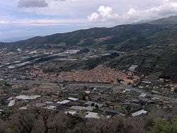
Taggia is a comune (municipality) in the Province of Imperia in the Italian region Liguria, located about 110 kilometres (68 miles) southwest of Genoa and about 15 km (9 mi) west of Imperia. It has around 13,000 inhabitants.
Taggia borders the following municipalities: Badalucco, Castellaro, Ceriana, Dolcedo, Pietrabruna, Riva Ligure, and Sanremo.
Geography
The town is divided into three parts: Taggia proper, the historical centre, in the Valle Argentina; Levà, including the industrial area; and Arma, a sea resort.
History
Tombs dating from the 10th-7th centuries BC have been found in the area of Taggia. During the Roman domination it was an important commercial port, known as Costa Balenae. After the fall of the Western Roman Empire, the old centre was damaged by the invasion of Rotharis's Lombards and then by a landslide in 690. The inhabitants moved to a new walled settlement, called Tabia. Despite its defences, in 889 it was sacked and razed to the ground by the Saracens
The rebuilt burgh became in 1153 a fief of the Clavesana family, but soon later it was acquired by the Republic of Genoa. In 1273 it became an autonomous commune, later receiving a podestà named in Genoa, under which it remained until its disappearing in the Napoleonic Wars. Later it was part of the Kingdom of Sardinia (1815) and of the Kingdom of Italy (1861).
Main sights
- Basilica of San Giacomo and San Filippo (1675–1681), built on an 11th-century Romanesque church.
- Church of Santa Maria del Canneto (10th or 14th century).
- Church of San Martino di Tours, housing 15th-century frescoes.
- Convent of San Domenico (160–1490). It has some pictures painted by Ludovico Brea.
- Palazzo Asdente (1473).
- Palazzo Curlo (1448).
- Palazzo Vivaldi (1458).
Transport
Taggia is situated on the Via Aurelia (now a provincial road). It has also a gate on the A10 Highway.
Taggia has a railway station on the Genoa–Ventimiglia line.
References
External links
| Wikimedia Commons has media related to Taggia. |