Table Rock, Missouri
| Table Rock, Missouri | |
|---|---|
| Former Village | |
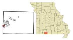 Location of Table Rock, Missouri | |
| Coordinates: 36°36′19″N 93°17′55″W / 36.60528°N 93.29861°WCoordinates: 36°36′19″N 93°17′55″W / 36.60528°N 93.29861°W | |
| Country | United States |
| State | Missouri |
| County | Taney |
| Area | |
| • Total | 0.2 sq mi (0.5 km2) |
| • Land | 0.2 sq mi (0.5 km2) |
| • Water | 0.0 sq mi (0.0 km2) |
| Elevation | 938 ft (286 m) |
| Population (2000) | |
| • Total | 229 |
| • Density | 1,094.1/sq mi (422.4/km2) |
| Time zone | Central (CST) (UTC-6) |
| • Summer (DST) | CDT (UTC-5) |
| FIPS code | 29-72160[1] |
| GNIS feature ID | 0753046[2] |
Table Rock was a village in Taney County, Missouri, United States. The population was 229 at the 2000 census. It is part of the Branson, Missouri Micropolitan Statistical Area. It is located just west of the Table Rock Lake dam on the White River (Arkansas). It is approximately 5 miles southwest from Downtown Branson. It was annexed by Branson in 2004.[3]
Geography
Table Rock is located at 36°36′19″N 93°17′55″W / 36.60528°N 93.29861°W (36.605284, -93.298497).[4]
According to the United States Census Bureau, the village has a total area of 0.2 square miles (0.5 km²), all of it land.
Demographics
As of the census[1] of 2000, there were 229 people, 96 households, and 69 families residing in the village. The population density was 1,094.1 people per square mile (421.0/km²). There were 114 housing units at an average density of 544.7 per square mile (209.6/km²). The racial makeup of the village was 94.76% White, 0.44% African American, 0.87% Native American, and 3.93% from two or more races. Hispanic or Latino of any race were 4.80% of the population.
There were 96 households out of which 25.0% had children under the age of 18 living with them, 60.4% were married couples living together, 6.3% had a female householder with no husband present, and 28.1% were non-families. 20.8% of all households were made up of individuals and 1.0% had someone living alone who was 65 years of age or older. The average household size was 2.39 and the average family size was 2.74.
In the village the population was spread out with 18.3% under the age of 18, 7.0% from 18 to 24, 35.8% from 25 to 44, 26.6% from 45 to 64, and 12.2% who were 65 years of age or older. The median age was 41 years. For every 100 females there were 89.3 males. For every 100 females age 18 and over, there were 94.8 males.
The median income for a household in the village was $40,000, and the median income for a family was $55,417. Males had a median income of $31,250 versus $27,500 for females. The per capita income for the village was $20,846. About 2.9% of families and 5.7% of the population were below the poverty line, including 4.9% of those under the age of eighteen and 5.6% of those sixty five or over.
References
- 1 2 "American FactFinder". United States Census Bureau. Retrieved 2008-01-31.
- ↑ "US Board on Geographic Names". United States Geological Survey. 2007-10-25. Retrieved 2008-01-31.
- ↑ "Boundary Changes".
- ↑ "US Gazetteer files: 2010, 2000, and 1990". United States Census Bureau. 2011-02-12. Retrieved 2011-04-23.
Municipalities and communities of Taney County, Missouri, United States | ||
|---|---|---|
| Cities | 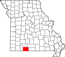 | |
| Villages | ||
| Townships |
| |
| CDP | ||
| Other unincorporated communities | ||
| Footnotes | ‡This populated place also has portions in an adjacent county or counties | |