Tablas Island
.svg.png) Tablas Location within the Philippines | |
| Geography | |
|---|---|
| Coordinates | 12°24′19″N 122°3′51″E / 12.40528°N 122.06417°ECoordinates: 12°24′19″N 122°3′51″E / 12.40528°N 122.06417°E |
| Archipelago | Romblon Group of Islands |
| Adjacent bodies of water | |
| Area | 839.156 km2 (324.000 sq mi) |
| Highest elevation | 665 m (2,182 ft) |
| Highest point | Mount Payaopao |
| Administration | |
|
Philippines | |
| Region | MIMAROPA |
| Province | Romblon |
| Municipalities | |
| Largest settlement | Odiongan (pop. 45,367) |
| Demographics | |
| Population | 164,012[1] (01 Aug 2015) |
Tablas is the largest of the islands that comprise the province of Romblon in the Philippines. The name of the island was of Spanish origin. Before the colonization of the Philippines, Tablas was known as the Island of Osigan. At the time of contact with Westerners, Osigan had a population of two hundred and fifty people living in small villages. Wax was produced in this island.[2]
Odiongan, on the west central coast of the island, is a major port and the largest municipality of Romblon in terms of population.[1] Tablas is administratively subdivided into the municipalities of Alcantara, Calatrava, Ferrol, Looc, Odiongan, San Agustin, San Andres, Santa Fe, and Santa Maria.
Geography
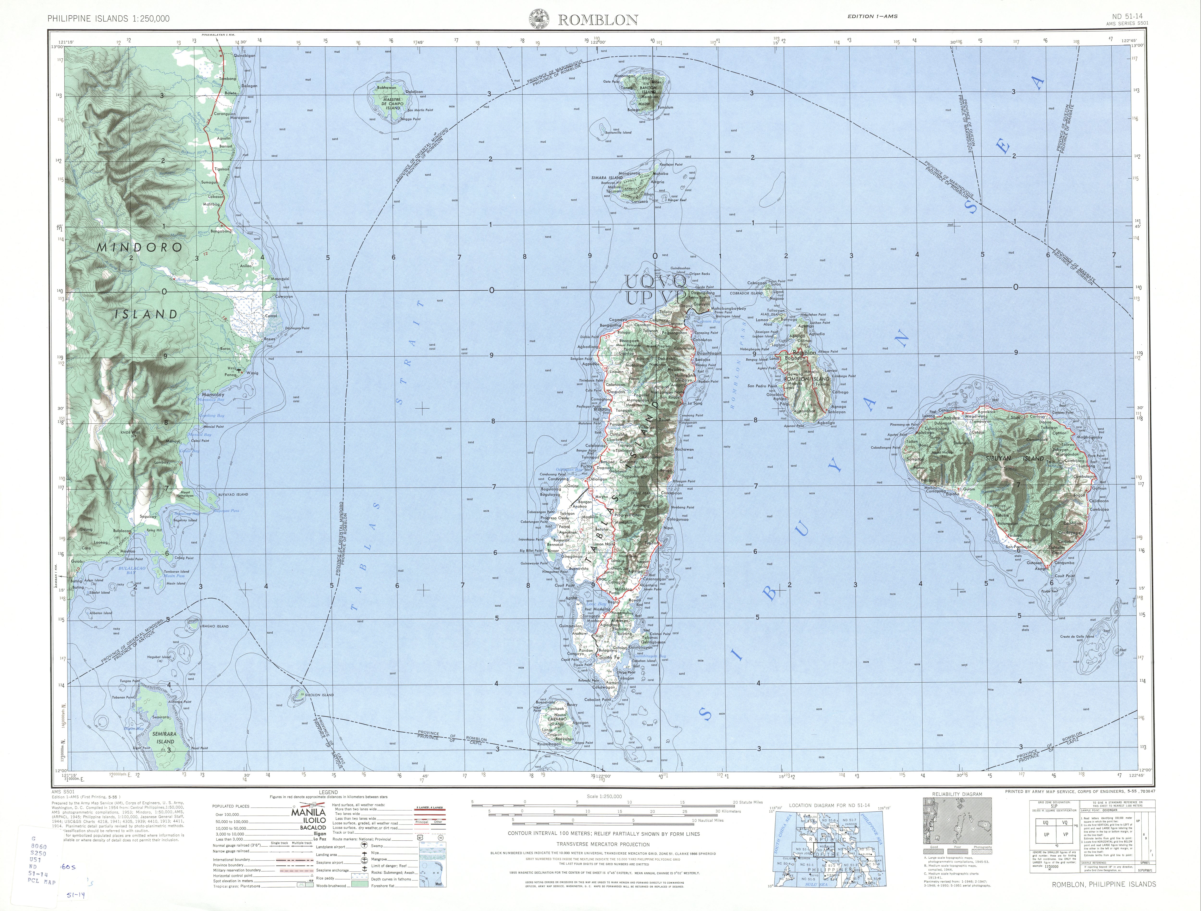
The island lies about 50 kilometres (31 mi) east from the southern part of Mindoro Island. The northern tip of Tablas is about 12 kilometres (7.5 mi) from Romblon Island. Mount Payaopao (also known as Tablas Summit on old maps) at the northeastern extremity of the island, is the highest peak on the island at 2,182 feet (665 m) high and the second highest in the province (after Mount Guiting-Guiting).[3][4]
A wooded central range of hills traverses the length of Tablas. The west coast is formed by the western slope of the central mountain ridge, which is narrow and well defined. The summits in the middle of the island are 1,600 to 2,000 feet high. In the center of the island is Bitaogan Peak, 2,164 feet (660 m) high, which appears as a rounded knob from east and west and sharp from north and south. Mount Lunas, at the back of Looc Bay, is a black ridge 1,556 feet (474 m) high, long and rounded from east and west and sharp from north and south; with it the range breaks off to the low pass from Looc Bay to the town of Alcantara on the east coast. The southern part of Tablas is a group of many sharp conical hills, all bare and grassy except Malbug Hill, 904 feet (276 m) high, and Calaton Point, 835 feet (255 m) high, on the east coast, which are dark and wooded. The shore line is largely mangrove, with many beaches of coral sand and some limestone cliffs. The shore reef is continuous except off Guinauayan Point.[5]
There is no good natural harbor except Looc Bay, a large indentation on the west side, but sheltered anchorage may be found on either side of the island, according to the season of the year.[5]
Cabalian Point, the southern extremity of Tablas Island, is low and sandy and hard to distinguish at night, a lighthouse was built during the American Colonial period.
Education
Romblon State University is a premier institution for higher education in the MIMAROPA Region. The University has a large campus in Odiongan town and a few more around Romblon province.
Economy
Main occupations are fruit and vegetable farming, fisheries, farm animal breeding and fishing. Tablas is one of largest producers of pili nuts.
Tablas was established an economic zone, Tablas Economic Zone Inc. (TEZI), on 2015 under the powers of the Philippine Economic Zone Authority (PEZA) and the Department of Trade and Industry (DTI)
Language
The Asi language is a Visayan language spoken, along with the Romblomanon and Onhan languages, in the province of Romblon, Philippines.[6] Tagalog is spoken by the locals as the second language. Foreigners are a welcome diversion for college students, who are the main part of the population who can speak English.
Tourism

Tablas has been little impacted by tourism, accommodations and resorts, though, are available around the island.[7] there are a lot of resorts now, for example Binucot Beach Resort and Bar or Sunset Cove Resort, both located at Binucot Beach which means "hidden beach" in the Philippine language
Attractions
Tropical Tablas has retained its original character. The Wildlife and landscape appears untouched as deep-green vegetation is crossed by rivers and streams. Tablas Island provides a wide variety of outdoor activities. Visitors can explore wonderful waterfalls and caves surrounded by tropical nature. Sig-Kop Cave, Mablaran Falls, Garing Falls, Mainit Falls, or turquoise colored Linao D Victo are natural attractions in Tablas. In the middle of the island scenery becomes hilly and mountainous. The highest mountain is Mt. Payaopao with 665 meters (2182 feet) located in the municipal of San Augustin. But it is not necessary to climb mountains to get stunning views. Through partial winding roads arise magnificent outlooks on surrounding nature. Roads are mostly paved with asphalt some are covered with gravel. Tablas is not nearly as frequented by tourists compared to Boracay. Therefore, the beaches are deserted and quiet.
Waterfalls
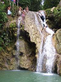
- Mainit Falls, located about an hour hike north of Poctoy Port, is on a private property and not signposted, but is open to the public.[8]
- Dubduban-Bita Falls in Brgy. Dubduban, 3 km. from the town proper of San Agustin is a 7-tier cascade amidst dense vegetations and cool surroundings.[9]
- "Mablaran falls", located in Brgy. Linawan San Andres, Romblon at least 8 km from the town proper of[(San Anres, Romblon)]...
Lakes
- Tinagong Dagat in Brgy. Kabibihan in Calatrava are two small, semi-circular saltwater lakes located only about 10 metres (33 ft) from the sea. The largest has a maximum diameter of 108 metres (354 ft), the smaller about 35 metres (115 ft). Both are deep and have cave-like formations under.[9] One peculiar thing about Tinagong Dagat is that when it is high tide, Tinagong Dagat is in low tide and vice versa.
Beaches

- Aglicay and Binay-we beaches in Alcantara
- Atabay and Guin-awayan beaches in Ferrol[9]
- Binucot (Dolphin) Beach in Ferrol/Bunsoran
- Puro Island, just off the coast of Santa Fe
- Saptos beach in Mabini, San Andres is one of rarest of all because of shoe shaped rock formation. It has also white sand.
Wildlife
The Wildlife and landscape appears untouched as deep-green vegetation is crossed by rivers and streams. A portion of the native forest cover has been removed and converted to coconut plantations, or rough grazing. However, the remaining small areas of watershed forest support several species of endemic wildlife that occur only on Tablas, or on just Tablas and Romblon Island. These include the Tablas Fantail Rhipidura sauli, the Tablas Drongo Dicrurus menagei, the Romblon Hawk Owl Ninox spilonota, and the Tablas Bulbul Hypsipetes (siquijorensis) cinereiceps. The frogs Platymantis_lawtoni and Platymantis levigatus are endangered species endemic to Tablas and other islands of Romblon province. In Ferrol at Malcom's Cove, monkeys, sea turtles and the Philippine eagle. In Santa Fe the whale shark (the earth's largest fish) is known to breed. The waters off Looc team with numerous species of tropical fish and sea life in the protected sanctuary. Binucot Beach has manatee, dolphin and sea turtles.
Scuba Diving
Tablas has only one Dive Center, First Buddy Divers, which operates out of Binucot Sunset Cove Resort near Ferrol. First Buddy Divers is a full service dive centre that offers both PADI and TDI courses. They can cater to recreational and technical divers.
The diving on Tablas Island is world class and virtually unexplored. The water is a comfortable 26 Celsius and the visibility is generally +20m and as diving tourism is fairly new here crowds are non-existent; on any given day you may be the only person diving on the entire island.
There are numerous walls around the island that go down to +60m and are covered in both soft and hard corals. Caves are commonly found along these walls as they are made of soft rock. Reefs around the island are extensive.
Access
By water
Access to Tablas is usually by ferry from the Port of Batangas City in southern Luzon and disembarking at the Port of Odiongan in Barangay Poctoy.[12]
Montenegro Lines serves Odiongan from the Port of Batangas City six days per week with Roll-on/roll-off vessels, then heading to Romblon Island from Poctoy and returning the next day. Travel time from Batangas to Poctoy takes about 8–10 hours. Travel time from Poctoy Pier to Odiongan town is about 10 minutes by motorcycles. Tricycles are also readily available.[13]
By air
The main commercial airport of the province of Romblon is Tugdan Airport (IATA: TBH – ICAO: RPVU) located in the southeastern coast of Tablas in Barangay Tugdan, in the town of Alcantara.
From Manila, Philippine Airlines (PAL) serves Tugdan three times a week.
Images
 Poctoy Pier, Tablas Island, 2008
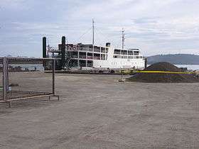 MV Maria Matilda at Poctoy Pier, Odiongan, Tablas Island 2008
 Mainit Falls, Tablas Island, 2008
References
- 1 2 = 175900000®Code = 17®Name = REGION+IV-B+%28MIMAROPA%29 "Romblon Municipalities and Cities". Philippine Standard Geographic Code Interactive. Retrieved on 2011-06-05.
- ↑ Miguel de Loarca, Relacion de las Yslas Filipinas (Arevalo: June 1782) in BLAIR, Emma Helen & ROBERTSON, James Alexander, eds. (1903). The Philippine Islands, 1493–1803. Volume 05 of 55 (1582–1583). Historical introduction and additional notes by Edward Gaylord BOURNE. Cleveland, Ohio: Arthur H. Clark Company. ISBN 978-0554259598. OCLC 769945704. "Explorations by early navigators, descriptions of the islands and their peoples, their history and records of the catholic missions, as related in contemporaneous books and manuscripts, showing the political, economic, commercial and religious conditions of those islands from their earliest relations with European nations to the beginning of the nineteenth century.", p. 73.
- ↑ "Romblon Map - U.S. Corps of Engineer". University of Texas in Austin Library. Retrieved on 2011-06-05.
- ↑ Mancuyas, Mario M. (2003-02-21). "San Agustin". Sanrokan News Magazine. Retrieved on 2011-06-05.
- 1 2 U.S. Coast and Geodetic Survey. "United States Coast Pilot, Philippine Islands, Part 1", p.186. Washington Government Printing Office, 1919.
- ↑ "Romblon Province languages". A Romblon Province Website. Retrieved on 2011-06-05.
- ↑ "Romblon Province Tablas Island Hotel & Resort Accommodations". Romblon Province, Marble Country of the Philippines. Retrieved on 2011-06-05.
- ↑ "Romblon". Travel Dojo. Retrieved on 2011-06-05.
- 1 2 3 "Romblon Towns & Cities". Biyahero.net. Retrieved on 2011-06-05.
- ↑ New records and other observations of birds on the island of Tablas, Romblon province, Philippines (Forktail 22: 77-84, 2006) Desmond Allen http://www.orientalbirdclub.org/publications/forktail/22pdfs/Allen-Tablas.pdf
- ↑ Vocal divergence and new species in the Philippine Hawk Owl Ninox philippensis complex (Forktail 28: 1-20, 2012) P. C. RASMUSSEN, D. N. S. ALLEN, N. J. COLLAR, B. DEMEULEMEESTER, R. O. HUTCHINSON, P. G. C. JAKOSALEM, R. S. KENNEDY, F. R. LAMBERT & L. M. PAGUNTALAN
- ↑ "Romblon - Getting there". Carabao Hotels. Retrieved on 2011-06-05.
- ↑ "Getting to Tablas Island". White Beach Boracay. Retrieved on 2013-02-14.
External links
-
 Media related to Tablas Island at Wikimedia Commons