Tabina, Zamboanga del Sur
| Tabina | |
|---|---|
| Municipality | |
 Map of Zamboanga del Sur with Tabina highlighted | |
.svg.png) Tabina Location within the Philippines | |
| Coordinates: 07°28′N 123°25′E / 7.467°N 123.417°ECoordinates: 07°28′N 123°25′E / 7.467°N 123.417°E | |
| Country | Philippines |
| Region | Zamboanga Peninsula (Region IX) |
| Province | Zamboanga del Sur |
| District | 2nd district of Zamboanga del Sur |
| Barangays | 15 |
| Government[1] | |
| • Mayor | Fruby Dayondon |
| Area[2] | |
| • Total | 86.90 km2 (33.55 sq mi) |
| Population (2010)[3] | |
| • Total | 25,061±0 |
| Time zone | PST (UTC+8) |
| ZIP code | 7034 |
| Dialing code | 62 |
| Income class | 4th class; partially urban |
Tabina is a 4th class municipality in the province of Zamboanga del Sur, Philippines. According to the 2014 census, it has a population of 25,061±0 people.[3]
Geography
It is the southernmost part of Zamboanga del Sur, facing the area wherein the waters of Illana Bay flows out to the Moro Gulf.It is about 63 kilometers away from Pagadian City, the province’s capital. Its boundaries are the municipality of Dimataling on the north, the Celebes Sea on the south, the municipality of Pitogo on the west, and another body of water, Illana Bay, on the east. Tabina can be reached via land through a provincial road passing through five municipalities so those who are thinking of going to Tabina should prepare for a long journey through rural places. The municipality has a land area of 8,690 hectares and these are distributed to the municipality’s current 15 regular and de-facto barangays.
Barangays
Tabina is politically subdivided into 15 barangays.[2]
- Abong-abong
- Baganian
- Baya-baya
- Capisan
- Concepcion
- Culabay
- Doña Josefina
- Lumbia
- Mabuhay
- Malim
- Manicaan
- New Oroquieta
- Poblacion
- San Francisco
- Tultolan
History
Tabina was formed out of the Municipality of Dimataling on August 16, 1961, by virtue of Executive Order No. 443 signed by President Carlos P. Garcia. Upon its creation, Tabina has twelve (12) barangays which comprised its original territory.
4 new barangays (Capisan, Doña Josefina, New Oroquita, San Francisco) were later created. When the Municipality of Pitogo was created, barangay Limbayan was detached from the Municipality of Tabina to be added to the new municipality, thus, resulting in a total number of fifteen (15) barangays within its jurisdiction.
Historically, the earliest settlers of Tabina were the Subanens who have settled in the different parts of the Zamboanga Peninsula. They are followed by the Muslims, and then the Christians. The name itself has many different origins, open to interpretation. One states that it comes from the inhabitants’ expression of “tabi-una”, a polite expression meaning “excuse me”. Another points out to the inhabitants’ characteristic expression of being talkative which, in the local tongue, is being “tabi-an”. Meanwhile, the Muslim immigrants were said to be attracted by the abundance of local seashells known as “binga” in their native tongue. It also happened to be called “ubina”. The Christians who happened to pass by Tabina inquired about the name of the place and, always hearing “bina”, modified it to “Tabina” and the name has stuck ever since. Most of Tabina is characterized as having steep mountains and undulating hills. The majority of the barangays tower to about 50 to 200 feet above sea level. There are no coastal plains or valleys in the municipality; the coasts themselves run down to shores and high cliffs. There are several tourist attractions in Tabina as well. There’s the Tambunan Beach and Marine Sanctuary, the Barangay Malim and Marine Sanctuary, Talisay Beach, and the Pod-ok Mangrove Boardwalk.
Demographics
| Population census of Tabina | ||
|---|---|---|
| Year | Pop. | ±% p.a. |
| 1990 | 19,422 | — |
| 1995 | 20,210 | +0.75% |
| 2000 | 21,882 | +1.72% |
| 2007 | 23,798 | +1.16% |
| 2010 | 24,110 | +0.48% |
| Source: National Statistics Office[3] | ||
Tourist Attractions
- Tambunan Beach and Marine Sanctuary
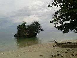 Marine Sanctuary
 Tambunan Beach Landscape
 Tambunan Villas
 Marine Sanctuary
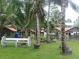

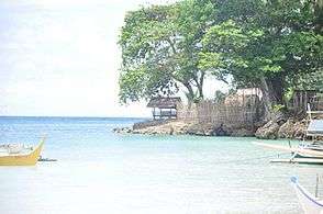
- Talisay Beach and Barangay Malim Marine Sanctuary
 Talisay Beach
 Talisay Beach
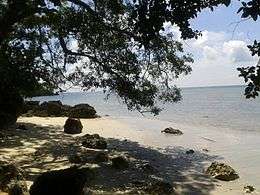 Talisay Beach
- Pod-ok Mangrove Boardwalk
- Baliti Beach Resort
- Baganian Beach Resort
Education
Tertiary
- Josefina E. Cerilles State College (Tabina Campus)
Secondary
(Private)
- Saint Ambrose High School
(Public)
- Baganian National High School
- Concepcion National High School
- Culabay National High School
- Malim National High School
- Tabina National High School
- Tultolan National High School
Elementary
- Abong-Abong Elementary School
- Baganian Elementary School
- Concepcion Elementary School
- Culabay Elementary School
- Lumbia Elementary School
- Mabuhay Elementary School
- Malim Elementary School
- San Antonio Elementary School (Baganian)
- San Roque Elementary School
- Tabina Central Elementary School
- Sto. Domingo Elementary School (Malim)
Gallery
More Views
 Malim Detachment
 Barangay Malim
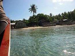 Barangay Malim
 Malim Lighthouse
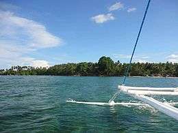 Malim Panoramic View
References
- ↑ "Official City/Municipal 2013 Election Results". Intramuros, Manila, Philippines: Commission on Elections (COMELEC). 12 May 2014. Retrieved 17 July 2014.
- 1 2 "Province: ZAMBOANGA DEL SUR". PSGC Interactive. Makati City, Philippines: National Statistical Coordination Board. Retrieved 16 July 2014.
- 1 2 3 "Total Population by Province, City, Municipality and Barangay: as of May 1, 2010" (PDF). 2010 Census of Population and Housing. National Statistics Office. Retrieved 16 July 2014.
External links
 |
Dimataling | Illana Bay | | |
| Pitogo | |
Illana Bay | ||
| ||||
| | ||||
| Moro Gulf |
Pagadian (capital) | |
| Municipalities | |
| Component city | |
| Highly urbanized city |
|