Tōmei Expressway
| |
|---|---|
| 東名高速道路 | |
 | |
| Route information | |
|
Part of | |
| Length: | 346.8 km[1] (215.5 mi) |
| Existed: | 1968[2][3] – present |
| Major junctions | |
| From: |
Tokyo Interchange in Setagaya, Tokyo Tokyo Metropolitan Route 311 |
| To: |
Komaki Interchange in Komaki, Aichi |
| Location | |
| Major cities: | Kawasaki, Yokohama, Atsugi, Fuji, Shizuoka, Hamamatsu, Toyokawa, Toyota, Nagoya, Kasugai |
| Highway system | |
|
National highways of Japan Expressways of Japan | |
The Tōmei Expressway (東名高速道路 Tōmei Kōsoku Dōro) is a national expressway on the island of Honshū in Japan. It is operated by Central Nippon Expressway Company. It is a part of Asian Highway Network ![]()
Naming
The word Tōmei is an acronym consisting of two kanji characters. The first character refers to Tokyo (東京) and the second refers to Nagoya (名古屋), which are the two major urban areas linked by the expressway.
Officially the expressway is designated as the First Tōkai Expressway.[4] A Second Tōkai Expressway (operating as the New Tōmei Expressway) is under construction parallel to the existing route which will alleviate congestion problems [5] in the near term.
The expressway is also a part of Route AH1 of the Asian Highway Network.[6][7]
Overview
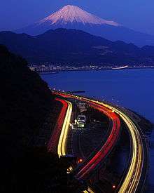
The Tōmei Expressway is an important roadway linking Tokyo and Nagoya. It is the most heavily travelled roadway operated by Central Nippon Expressway Company, with some sections used by more than 100,000 vehicles a day.[5]
The first sections were opened to traffic in 1968 and the entire route was completed in 1969.[2]
From the origin in western Tokyo the expressway follows a westerly route through Kanagawa Prefecture, paralleling National Route 246 and passing to the north of Yokohama. The route continues west into Shizuoka Prefecture, passing to the south of Mount Fuji and along the coastline of Suruga Bay, paralleling National Route 1 and the historic Tōkaidō highway before reaching the city of Shizuoka. The expressway continues west, passing Lake Hamana in western Shizuoka Prefecture, and crosses into Aichi Prefecture. The expressway then heads northwest, passing to the east of the city of Nagoya and meeting the terminus of the Chūō Expressway before terminating at an interchange in the city of Komaki to the north of Nagoya. Although the Tōmei Expressway ends at this point, the roadway continues as the Meishin Expressway towards Kyoto, Osaka, and Kobe.
List of interchanges and features
- IC - interchange, SIC - smart interchange, JCT - junction, SA - service area, PA - parking area, BS - bus stop, TN - tunnel, TB - toll gate, BR - bridge
| No. | Name | Connections | Dist. from Origin |
Bus Stop | Notes | Location | |
|---|---|---|---|---|---|---|---|
| Through to | |||||||
| 1 | Tokyo IC | Met. Route 311 (Kampachi Dori) | 0.0 | Setagaya | Tokyo | ||
| - | Tōmei JCT | ↓ | Planned | ||||
| BR | Tamagawa Bridge | ↓ | Tama River crossing | ||||
| Tama-ku, Kawasaki | Kanagawa | ||||||
| - | Shukugawara JCT | ↓ | Planned | ||||
| TB | Tokyo Toll Gate/ Mukaigaoka Bus Stop |
6.7 | ○ | Miyamae-ku, Kawasaki | |||
| 3 | Tōmei-Kawasaki IC | 7.6 | |||||
| BS | Eda Bus Stop | 10.5 | ○ | Aoba-ku, Yokohama | |||
| 3-1 | Yokohama-Aoba IC | 13.3 | |||||
| PA | Kōhoku PA | 14.2 | Midori-ku, Yokohama | ||||
| 4 | Yokohama-Machida IC/ Yokohama Bus Stop |
19.7 | X | Bus Stop closed | |||
| BS | Yamato Bus Stop | 24.0 | ○ | Yamato | |||
| TN | Yamato Tunnel | ↓ | |||||
| BS | Ayase Bus Stop | 28.8 | ○ | Ayase | |||
| - | Ayase IC | Pref. Route 42 (Fujisawa Zama Atsugi Route) | 33.9 | Planned | |||
| SA | Ebina SA | 31.3 | Ebina | ||||
| 4-1 | Ebina-kita JCT | 33.9 | |||||
| 5 | Atsugi IC | 35.0 | Atsugi | ||||
| BS | Atsugi Bus Stop | 36.7 | ○ | ||||
| BS | Isehara Bus Stop | 41.7 | ○ | Isehara | |||
| - | Isehara JCT | ↓ | Planned | ||||
| 5-1 | Hadano-Nakai IC/ Hadano Bus Stop |
Pref. Route 71 (Hadano Ninomiya Route) |
50.1 | ○ | Hadano | ||
| PA | Nakai PA | 53.6 | Nakai | ||||
| BS | Ōi Bus Stop | 57.1 | ○ | Ōi | |||
| 6 | Ōi-Matsuda IC | Pref. Route 78 (Gotenba Ōi Route) |
57.9 | ||||
| BS | Matsuda Bus Stop | 60.2 | ○ | Matsuda | |||
| BS | Yamakita Bus Stop | 63.6 | ○ | Yamakita | |||
| TN | Azumayama Tunnel | ↓ | |||||
| TN | Shintsuburano Tunnel (Komaki-bound) Tsuburano Tunnel (Tokyo-bound) |
↓ | |||||
| TN | Torideyama Tunnel | ↓ | Tokyo-bound only | ||||
| TN | Tarogao Tunnel | ↓ | |||||
| TN | Kitahata Tunnel | ↓ | |||||
| PA | Ayuzawa PA | 71.9(↓) 72.5(↑) |
Komaki-bound: Accessible only to Left Route | ||||
| TN | Sakuradaira Tunnel | ↓ | Tokyo-bound only | Oyama | Shizuoka | ||
| TN | Takao Tunnel | ↓ | |||||
| BS | Oyama Bus Stop | 75.5 | ○ | Komaki-bound: Accessible only to Left Route | |||
| TN | Shoryo Tunnel | ↓ | Tokyo-bound only | ||||
| TN | Shirahata Tunnel | ↓ | |||||
| BR | Tomei Ashigara Bridge | ||||||
| BS | Ashigara Bus Stop | 79.2 | ○ | ||||
| SA | Ashigara SA | 80.9 | |||||
| Gotenba | |||||||
| 7 | Gotenba IC (No.2) | 83.7 | Komaki-bound exit, Tokyo-bound entrance only | ||||
| Gotenba IC (No.1)/ Gotenba Bus Stop |
Pref. Route 401 (Gotenba Hakone Route) | ○ | |||||
| 7-1 | Gotenba JCT | 88.3 | Tokyo-bound only | ||||
| PA | Komakado PA | 89.9(↓) 90.0(↑) |
X | Bus Stop closed | |||
| 7-2 | Susono IC | Pref. Route 82 (Susono Inter Route) |
93.8 | Susono | |||
| BS | Susono Bus Stop | 95.5 | ○ | ||||
| 8 | Numazu IC | Pref. Route 83 (Numazu Inter Route) |
103.3 | ○ | Numazu | ||
| PA | Ashitaka PA | 105.9 | ○ | ||||
| BS | Hara Bus Stop | ↓ | X | Closed | |||
| BS | Nakazato Bus Stop | 115.7 | ○ | Fuji | |||
| 9 | Fuji IC | Pref. Route 353 (Tagourakō Fuji Inter Route) |
121.5 | ○ | |||
| BS | Matsuoka Bus Stop | 125.0 | ○ | ||||
| 9-1 | Fujikawa SA/ SIC |
Pref. road No. 10 (Fujikawa-Minobu Route) | 127.5 | ○ | |||
| TN | Kanbara Tunnel | ↓ | Length - 710 m | Shimizu-ku, Shizuoka | |||
| BS | Kanbara Bus Stop | 133.1 | ○ | ||||
| PA | Yui PA | 138.6(↓) 139.7(↑) |
|||||
| TN | Satta Tunnel | ↓ | |||||
| BS | Okitsu Bus Stop | 142.5 | ○ | ||||
| TN | Okitsu Tunnel | ↓ | |||||
| TN | Seikenji Tunnel | ↓ | |||||
| TN | Sodeshi Tunnel | ↓ | |||||
| 9-2 | Shimizu JCT | 146.4 | |||||
| 10 | Shimizu IC | 147.8 | ○ | ||||
| PA | Nihondaira PA | 155.8 | ○ | Suruga-ku, Shizuoka | |||
| 11 | Shizuoka IC | Pref. Route 84 (Nakajima Minamiabe Route) | 161.8 | ○ | |||
| TN | Nihonzaka Tunnel | ↓ | Tokyo-bound Left Route - 2,380 m Tokyo-bound Right Route - 2,370 m Komaki-bound - 2,555 m | ||||
| Yaizu | |||||||
| PA | Nihonzaka PA | 171.5(↓) 171.6(↑) |
|||||
| 12 | Yaizu IC | Pref. Route 81 (Yaizu Mori Route) | 173.6 | ||||
| BS | Yaizu-nishi Bus Stop | 176.1 | ○ | ||||
| BS | Ōigawa Bus Stop | 181.0 | ○ | ||||
| 13 | Yoshida IC | Pref. Route 34 (Shimada Yoshida Route) | 185.6 | ○ | Yoshida | ||
| SA | Makinohara SA/ Bus Stop |
194.5 | ○ | Makinohara | |||
| 13-1 | Sagara-Makinohara IC | 197.0 | |||||
| 14 | Kikugawa IC | Pref. Route 37 (Kakegawa Hamaoka Route) | 201.8 | ○ | Kikugawa | ||
| 14-1 | Kakegawa IC | 207.8 | ○ | Kakegawa | |||
| PA | Ogasa PA | 209.7 | |||||
| BS | Okatsu Bus Stop | 212.9 | ○ | ||||
| 15 | Fukuroi IC | Pref. Route 61 (Hamakita Fukuroi Route) | 219.4 | ○ | Fukuroi | ||
| 15-1 | Iwata IC | Pref. Route 86 (Iwata Inter Route) Pref. Route 283 (Yokokawa Iwata Route) |
223.3 | Former site of Iwatahara PA | Iwata | ||
| 15-2 | Enshū-Toyoda PA/ SIC |
225.2 | |||||
| BS | Iwata Bus Stop | 226.2 | ○ | ||||
| 16 | Hamamatsu IC | Pref. Route 65 (Hamamatsu Kanjō Route) | 230.0 | Higashi-ku, Hamamatsu | |||
| BS | Hamamatsu-kita Bus Stop | 233.5 | ○ | ||||
| PA | Mikatagahara PA | 234.9 | |||||
| 16-1 | Hamamatsu-nishi IC | Pref. Route 65 (Hamamatsu Kanjō Route) | 240.5 | Nishi-ku, Hamamatsu | |||
| BS | Kanzanji Bus Stop | 244.7 | ○ | ||||
| BR | Hamanako Bridge | ↓ | Length - 603 m | ||||
| Kita-ku, Hamamatsu | |||||||
| SA | Hamanako SA | 247.9 | ○ | ||||
| 17 | Mikkabi IC | Pref. Route 85 (Mikkabi Inter Route) Pref. Route 308 (Hōrai Mikkabi Route) |
251.1 | ||||
| TN | Mikkabi Tunnel | ↓ | |||||
| BS | Mikkabi Bus Stop | 255.0 | ○ | ||||
| 17-1 | Mikkabi JCT | 255.8 | |||||
| TN | Uri Tunnel | ↓ | |||||
| Shinshiro | Aichi | ||||||
| PA | Shinshiro PA | 261.1 | |||||
| BS | Toyohashi-kita Bus Stop | 262.3 | ○ | Toyohashi | |||
| 18 | Toyokawa IC | 269.0 | ○ | Toyokawa | |||
| PA | Akatsuka PA | 274.0 | |||||
| BS | Otowa Bus Stop | 279.1 | ○ | ||||
| 18-1 | Otowa-Gamagōri IC | Otowa-Gamagōri Toll Road |
280.2 | ||||
| BS | Motojuku Bus Stop | 285.4 | ○ | Okazaki | |||
| PA | Miai PA | 289.7 | |||||
| 19 | Okazaki IC | Pref. Route 26 (Okazaki Kanjō Route) |
293.4 | ○ | |||
| BS | Iwazu Bus Stop | 301.5 | ○ | ||||
| 19-1 | Toyota JCT | 304.1 | Toyota | ||||
| SA | Kamigō SA | 305.8 | ○ | ||||
| 20 | Toyota IC | Pref. Route 76 (Toyota Anjō Route) |
310.8 | ○ | |||
| 20-1 | Tōmei-Miyoshi IC/ Miyoshi Bus Stop |
Pref. Route 54 (Toyota Chiryū Route) | 315.8 | ○ | Miyoshi | ||
| PA | Tōgō PA | 318.1 | Nisshin | ||||
| BS | Nisshin Bus Stop | 319.3 | ○ | ||||
| 20-2 | Nisshin JCT | 322.3 | |||||
| 21 | Nagoya IC | Pref. Route 60 (Nagoya Nagakute Route) |
325.5 | Meitō-ku, Nagoya | |||
| BS | Asahi Bus Stop | 329.5 | X | Closed | Owariasahi | ||
| PA | Moriyama PA | 333.7 | Moriyama-ku, Nagoya | ||||
| 22 | Kasugai IC | 337.7 | X | Bus Stop closed | Kasugai | ||
| 23 | Komaki JCT | 339.9 | Komaki | ||||
| 24 | Komaki IC | 346.8 | |||||
| Through to | |||||||
Lanes

| Section | Tokyo-bound Lanes | Komaki-bound Lanes |
|---|---|---|
| Shuto Expressway - Tokyo IC | Two | |
| Tokyo IC - Ōi-Matsuda IC | Three | |
| Ōi-Matsuda IC - Ashigara BS | Three | Two (Left Route) + Two (Right Route) |
| Ashigara BS - Komakado PA | Three | |
| Komakado PA - Shizuoka IC | Two | |
| Shizuoka IC - Nihonzaka Tunnel | Three | Two |
| Nihonzaka Tunnel | Two (Left Route) + Two (Right Route) | Three |
| Nihonzaka Tunnel - Nihonzaka PA | Three | |
| Nihonzaka PA - Yaizu IC | Two | Three |
| Yaizu IC - Komaki IC | Two | |
- Sections with left and right routes formerly carried 2 lanes of traffic in each direction. An additional roadway (carrying 3 lanes of traffic in one direction only) has been constructed parallel to the existing 4 lanes to alleviate congestion. The original 4 lanes are then converted for the use of traffic in the opposite direction.
See also
References
- ↑ Ministry of Land, Infrastructure and Transport. "Road Timetable". Retrieved 2008-05-20.
- 1 2 Ministry of Land, Infrastructure and Transport. "History of Tokyo's 3 Ring Roads". Retrieved 2008-04-17.
- ↑ Japan Civil Engineering Contractors' Association. "Construction History of Japan". Retrieved 2008-05-20.
- ↑ Ministry of Land, Infrastructure and Transport. "High Standard Trunk Road Map" (pdf). Retrieved 2008-04-13.
- 1 2 "C-NEXCO Business Outline" (pdf). Retrieved 2008-05-20.
- ↑ Economic and Social Commission for Asia and the Pacific, 2003 Asian Highway Handbook, 2003, page 54 shows an aerial photo of the Yokohama Aoba Interchange, placing AH1 clearly on the Tomei Expressway rather than the other Tokyo-Nagoya expressway, the Chūō Expressway.
- ↑ UNESCAP Asian Highway Network Project. "Sectional AH Data for Japan" (excel). Retrieved 2008-05-20.
External links
| Wikimedia Commons has media related to Tomei Expressway. |
| East Nippon Expressway Company | |
|---|---|
| Central Nippon Expressway Company | |
| West Nippon Expressway Company |
|
| Honshū-Shikoku Bridge Expressway Company |
|
| Urban Expressways | |
Coordinates: 35°35′40″N 139°34′24″E / 35.594315°N 139.573410°E