Swisshelm Mountains
| Swisshelm Mountains | |
|---|---|
|
(black massif of Chiricahua Mountains with black Dos Cabezas Mountains attached at northwest) The Swisshelm Mountains is the small (1/4 length of Chiricahuas) subrange, just west of the south end of the Chiricahuas. (The wildfires smoke plume is blowing east x northeast.) | |
| Highest point | |
| Peak | Swisshelm Mountain |
| Elevation | 7,185 ft (2,190 m) [1] |
| Coordinates | 31°40′28″N 109°32′07″W / 31.67444°N 109.53528°W [2] |
| Dimensions | |
| Length | 22 mi (35 km) N-S |
| Width | 6 mi (9.7 km) |
| Geography | |
 Swisshelm Mountains in Arizona | |
| Country | United States |
| State | Arizona |
| Regions | Northeastern-Sonoran Desert, Rucker Canyon–Leslie Canyon Refuge and Madrean Sky Islands |
| County | Cochise County |
| Communities | |
| Range coordinates | 31°40′N 109°32′W / 31.67°N 109.54°WCoordinates: 31°40′N 109°32′W / 31.67°N 109.54°W |
| Borders on | Sulphur Springs Valley-W, Chiricahua Mountains-NE, Pedregosa Mountains-E/SE and Leslie Creek & Refuge-S & E |

| Wikimedia Commons has media related to Swisshelm Mountains. |
The Swisshelm Mountains are a small mountain range adjacent to the southwest corner of the Chiricahua Mountains of eastern Cochise County, Arizona. They are separated from the Pedrogosa Mountains to the southeast, the Chiricahua's to the northeast, and by Leslie Creek, bordering the south and east; the area is now notable for the Leslie Canyon National Wildlife Refuge.
The mountain range is named for John Swisshelm, a miner, a local settler of the late 1900s.[3]
Range
The range is a north-south range, with three notable peaks. In the south, Swisshelm Mountain is the highest at 7,185 feet (2,190 m). In the north, an unnamed peak is 5225 ft, and is adjacent to Whitewater Draw of the lower stretch of Rucker Creek. A second unnamed peak is in the northeast, at 5847 ft and also adjacent to Rucker Creek.
Leslie Creek forms the eastern and southern border of the Swisshelm Mountains. The Chiricahua's are directly adjacent eastwards; the Pedregosa Mountains are southeast and are drained by a tributary of Leslie Creek, Big Bend Creek.
The communities of Elfrida and McNeal are directly west of the Swisshelm's in the Sulphur Springs Valley; Douglas and Agua Prieta, Sonora are due south at about 15 miles (24 km). The historical area of Sunizona, Arizona is northwest-(Pearce, Arizona).
 'Greensward'
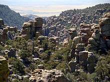 hoodoos
 hoodoos
 hoodoos
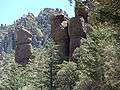 Trees and hoodoos
 Road scene
See also
- Leslie Canyon National Wildlife Refuge
- List of Madrean Sky Island mountain ranges - Sonoran - Chihuahuan Deserts
References
- ↑ "Swisshelm Mountain". Peakbagger.com. Retrieved 2015-04-11.
- ↑ "Swisshelm Mountain". Geographic Names Information System. United States Geological Survey. Retrieved 2015-04-11.
- ↑ Short history, John Swisshelm
External links
Geology