Swinburne Ice Shelf
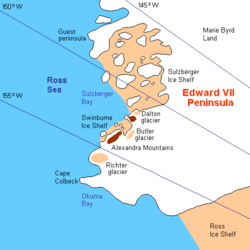
Swinburne Ice Shelf (77°10′S 153°55′W / 77.167°S 153.917°WCoordinates: 77°10′S 153°55′W / 77.167°S 153.917°W), is an ice shelf just north of Edward VII Peninsula and the Alexandra Mountains in the southern part of Sulzberger Bay, Antarctica. The ice shelf is 20 miles long and 5 miles wide and extends from Fisher Island to White Islands. It was photographed from aircraft and mapped by the Byrd Antarctic Expedition (ByrdAE), 1928-30. Named by Advisory Committee on Antarctic Names (US-ACAN) for Captain H.W Swinburne, Jr., Deputy Commander and Chief of Staff, U.S. Naval Support Force, Antarctica, during Operation Deep Freeze 1970 and 1971.[1]
See also
References
- ↑ "Swinburne Ice Shelf". Geographic Names Information System. United States Geological Survey. Retrieved 2009-11-13.
![]() This article incorporates public domain material from the United States Geological Survey document "Swinburne Ice Shelf" (content from the Geographic Names Information System).
This article incorporates public domain material from the United States Geological Survey document "Swinburne Ice Shelf" (content from the Geographic Names Information System).