Svappavaara
| Svappavaara | |
|---|---|
|
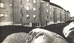
One of the original buildings at Svappavaara, designed by Ralph Erskine, which forms a long wind break. | |
 Svappavaara  Svappavaara | |
| Coordinates: 67°39′N 21°03′E / 67.650°N 21.050°ECoordinates: 67°39′N 21°03′E / 67.650°N 21.050°E | |
| Country | Sweden |
| Province | Lapland |
| County | Norrbotten County |
| Municipality | Kiruna Municipality |
| Area[1] | |
| • Total | 0.92 km2 (0.36 sq mi) |
| Population (31 December 2010)[1] | |
| • Total | 417 |
| • Density | 456/km2 (1,180/sq mi) |
| Time zone | CET (UTC+1) |
| • Summer (DST) | CEST (UTC+2) |
Svappavaara is a locality situated in Kiruna Municipality, Norrbotten County, Sweden with 417 inhabitants in 2010.[1] It is a mining village. Mining was started around 1650. Large scale iron mining started in 1965. The mine was closed in 1983, but enrichment of iron ore from the mine at Kiruna is still going on. The mine is owned by LKAB, and there is an ongoing project to open it again for production around year 2015.
The designers of Fermont, Quebec in northern Canada were inspired by Svappavaara and similar Swedish towns with regard to the windbreak building. In 2010, a portion of Erskine's windbreak building, "Ormen Långe" was demolished.[2]
References
- 1 2 3 "Tätorternas landareal, folkmängd och invånare per km2 2005 och 2010" (in Swedish). Statistics Sweden. 14 December 2011. Archived from the original on 10 January 2012. Retrieved 10 January 2012.
- ↑ Jnse, Demolition photos - Ormen Långe, Panoramio, 2010
This article is issued from Wikipedia - version of the 8/6/2016. The text is available under the Creative Commons Attribution/Share Alike but additional terms may apply for the media files.