Sutatenza
| Sutatenza | |||
|---|---|---|---|
| Municipality and town | |||
|
Church of Sutatenza | |||
| |||
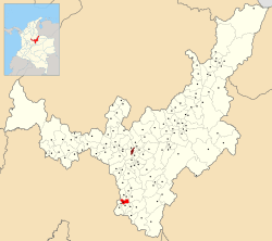 Location of the municipality and town of Sutatenza in the Boyacá Department of Colombia | |||
| Country |
| ||
| Department | Boyacá Department | ||
| Province | Eastern Boyacá Province | ||
| Founded | 22 October 1783 | ||
| Government | |||
| • Mayor |
Camilo Sastoque (2016-2019) | ||
| Area | |||
| • Municipality and town | 41.26 km2 (15.93 sq mi) | ||
| Elevation | 1,890 m (6,200 ft) | ||
| Population (2015) | |||
| • Municipality and town | 4,086 | ||
| • Density | 99/km2 (260/sq mi) | ||
| • Urban | 769 | ||
| Time zone | Colombia Standard Time (UTC-5) | ||
| Website | Official website | ||

.svg.png)

Sutatenza (Spanish pronunciation: [sutaˈtensa]) is a town and municipality in the Eastern Boyacá Province of the department of Boyacá, Colombia. It is located 125 kilometres (78 mi) from the Colombian capital Bogotá and 118 kilometres (73 mi) from the department capital Tunja. Sutatenza borders Somondoco, Guateque, Tenza and Garagoa.[1]
Etymology
The name Sutatenza comes from Chibcha and means either "Cloud behind the anchovy" or "Descending to the house of the cacique".[1][2]
History
In the time before the Spanish conquest, Sutatenza, situated in the Tenza Valley to the east of the Altiplano Cundiboyacense, was ruled by a cacique called Tenzuzucá or Tenzucá, loyal to the zaque of Hunza. Conquistador Gonzalo Jiménez de Quesada in his quest for El Dorado and the rich emerald deposits of the Muisca Confederation visited Sutatenza in 1537.
Modern Sutatenza was not founded until October 22, 1783.[1]
Economy
Main economical activities of Sutatenza are agriculture and aviculture. A small salt mine is operated in the vereda Salitre.[1]
Gallery
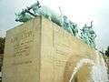 Monument to the farmers
 Ox market
References
- 1 2 3 4 (Spanish) Official website Sutatenza
- ↑ (Spanish) Etymology Sutatenza - Excelsio.net
| Wikimedia Commons has media related to Sutatenza. |
Coordinates: 5°01′N 73°27′W / 5.017°N 73.450°W