Surrey Heath
| Surrey Heath District | |
|---|---|
| Non-metropolitan district | |
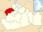 Surrey Heath shown within Surrey | |
| Sovereign state | United Kingdom |
| Constituent country | England |
| Region | South East England |
| Non-metropolitan county | Surrey |
| Status | Non-metropolitan district |
| Admin HQ | Camberley |
| Incorporated | 1 April 1974 |
| Government | |
| • Type | Non-metropolitan district council |
| • Body | Surrey Heath Borough Council |
| • Leadership | Leader & Cabinet (Conservative) |
| • MPs | Michael Gove |
| Area | |
| • Total | 36.7 sq mi (95.1 km2) |
| Area rank | 225th (of 326) |
| Population (mid-2014 est.) | |
| • Total | 87,533 |
| • Rank | 272nd (of 326) |
| • Density | 2,400/sq mi (920/km2) |
| • Ethnicity[1] |
95.4% White 2.1% S.Asian 1.0% Black 1.4% Chinese or Other 1.4% Mixed Race |
| Time zone | GMT (UTC0) |
| • Summer (DST) | BST (UTC+1) |
| ONS code |
43UJ (ONS) E07000214 (GSS) |
| OS grid reference | SU8752760851 |
| Website |
www |
Surrey Heath is a local government district with Borough status in Surrey, England. Its Council is based in Camberley. Much of the area is within the Metropolitan Green Belt.
History

The district was formed on 1 April 1974 under the Local Government Act 1972, as a merger of Frimley and Camberley Urban District, and Bagshot Rural District. The Borough acquired its name because it includes extensive areas of heath and woodland including Chobham Common and Lightwater Country Park.
Bagshot Rural District
Bagshot Rural District formed the largest part of Surrey Heath. The villages and hamlets in Bagshot rural district comprised Lightwater, Bagshot, Windlesham, Chobham including West End and Bisley.
The motto for the district was Festina Prudenter granted on 20 July 1960.
On the crest, the gold and white background was from the arms of Chertsey Abbey, which owned and is connected with the history of much of the district - Bagshot was included in a grant to the Abbey as early as 933. The stag's head on the crest refers to Bagshot Park, a royal demesne since Norman times and hunting ground of the Stuart kings, and also to the fact that much of the area was formerly part of Windsor Forest. The grenade on the crest refers to the area's military associations, in particular the former military camp at Chobham and the lion recalls the area's royal links. The fir cones and mound of heathland refers to Bagshot Heath, and the falcon is derived from the supporters of the Earls of Onslow.[2]
Governance
The Borough is governed by Surrey Heath Borough Council. Parish councils in Surrey Heath are in Bisley with the chairman being Cllr Barry Woodhead; Chobham with the chairman being Cllr Ian AC Taylor; West End with the chairman being Cllr David Elliott and Windlesham (which includes Lightwater and Bagshot) where the chairman is Cllr Keith Hand.[3]
Politics
The 3 May 2011 borough elections produced 35 Conservative, 1 Liberal Democrat, 2 Labour and 2 Independent councillors.[4] In 2014, the British Election Study named Surrey Heath as the most right-wing constituency in the country.[5]
In the Press
Surrey Heath was voted the 6th best place to live in Channel 4's 2007 Location, Location, Location 'best and worst' survey.[6]
Geography
The area forms the heart of the heath that spans Esher, Oxshott, Weybridge, Wisley, all around Woking, Brookwood, Deepcut, Pirbright, Frimley, Lightwater, Camberley, Chobham Common, Virginia Water and Ottershaw is naturally wet, very acid sandy and loamy soil, which is just 1.9% of English soil and 0.2% of Welsh soil, which gives rise to pines and coniferous landscapes, such as pioneered at Wentworth and Foxhills estate (now spa, hotel, restaurant and golf club) by pro-American Independence statesman Charles James Fox[7] In geology it gives rise to the name, Bagshot Formation.
The western section of the district is largely urbanised, with heaths nonetheless providing substantial green buffers Camberley, Lightwater, Deepcut, Frimley, Frimley Green and Mytchett. The east of the district is less urbanised, and contains Surrey Heath's four civil parishes:[8]
- Bisley
- Chobham (includes Castle Green and Mimbridge)
- West End
- Windlesham (contains also Bagshot, Lightwater and Valley End).
Within the borough there are five Sites of Special Scientific Interest, four of which are part of the Thames Basin Heaths Special Protection Area of European Importance as a habitat for certain endangered bird species; these make up some of the six Wildlife Reserves managed by Surrey Wildlife Trust in Surrey Heath.
Notable people
- Plymouth Argyle F.C and Wales national football team captain Carl Fletcher was born in Camberley.
Twinning
Surrey Heath is twinned with Sucy-en-Brie, France, and Bietigheim-Bissingen, Germany.[9]
Energy policy
In May 2006, a report commissioned by British Gas showed that housing in Surrey Heath produced the 3rd highest average carbon emissions in the country at an average of 7,477 kg of carbon dioxide per dwelling.[10]
References
- ↑ Office for National Statistics: Neighbourhood Statistics: Surrey Heath
- ↑ Civil heraldry
- ↑ Surrey Heath Councillors
- ↑ Surrey Heath councillors by political party retrieved 4/5/07
- ↑ http://www.bbc.co.uk/news/uk-politics-30129990
- ↑ Surrey Heath – Best and Worst Places to Live
- ↑ Cranfield University National Soil Resources Institute
- ↑ Surrey Council
- ↑ About Surrey Heath
- ↑ Centrica plc. Britishgasnews.co.uk (2013-02-27). Retrieved on 2013-07-17.
External links
- Chobham Common
- Lightwater Country Park
- Surrey Heath Borough Council
- Surrey County Council local pages
- Surrey Heath Local History Club
| Towns, villages and neighbourhoods |
| | ||||||||||||||||||||||||||
|---|---|---|---|---|---|---|---|---|---|---|---|---|---|---|---|---|---|---|---|---|---|---|---|---|---|---|---|---|
| Parks | ||||||||||||||||||||||||||||
| Listed Churches | ||||||||||||||||||||||||||||
| Education | ||||||||||||||||||||||||||||
| Transport |
| |||||||||||||||||||||||||||
| Buildings and structures | ||||||||||||||||||||||||||||
| Sport | ||||||||||||||||||||||||||||
Places listed are articles or sections notable as settlements, arranged by post town Camberley is the administrative centre and largest single settlement | ||||||||||||||||||||||||||||
Coordinates: 51°20′22″N 0°44′36″W / 51.3395°N 0.7433°W