Surkhet District
| Surkhet Jillā सुर्खेत जिल्ला | |
|---|---|
| District | |
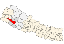 Location of Surkhet | |
| Country | Nepal |
| Region | Mid-Western (Madhya Pashchimanchal) |
| Zone | Bheri |
| Headquarters | Birendranagar |
| Area | |
| • Total | 2,451 km2 (946 sq mi) |
| Population (2011) | |
| • Total | 350,804 |
| • Density | 140/km2 (370/sq mi) |
| Time zone | NPT (UTC+5:45) |
| Website | www.ddcsurkhet.gov.np |
Surkhet District (Nepali: सुर्खेत जिल्ला, Surkhet Jillā ![]() Listen ) is one of Nepal's seventy-five districts of Nepal located about 600 kilometres (373 mi) west of the national capital Kathmandu. Surkhet is one of ten districts in Province No. 6. The district's area is 2,451 km². It had 288,527 population in 2001 and 350,804 in 2011. Birendranagar is the district headquarters, nominated for capital of the proposed Bheri-Karnali state of the new federal republic.
Listen ) is one of Nepal's seventy-five districts of Nepal located about 600 kilometres (373 mi) west of the national capital Kathmandu. Surkhet is one of ten districts in Province No. 6. The district's area is 2,451 km². It had 288,527 population in 2001 and 350,804 in 2011. Birendranagar is the district headquarters, nominated for capital of the proposed Bheri-Karnali state of the new federal republic.
Geography and Climate
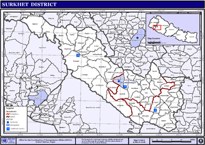
Surkhet Valley is one the Inner Terai Valleys of Nepal. Bordering districts are Jajarkot, Dailekh, and Achham to the north, Bardiya and Kailali to the south, Salyan district to the east, and Doti to the west.
| Climate Zone[1] | Elevation Range | % of Area |
|---|---|---|
| Lower Tropical | below 300 meters (1,000 ft) | 2.2% |
| Upper Tropical | 300 to 1,000 meters 1,000 to 3,300 ft. |
61.9% |
| Subtropical | 1,000 to 2,000 meters 3,300 to 6,600 ft. |
32.8% |
| Temperate | 2,000 to 3,000 meters 6,400 to 9,800 ft. |
1.3% |
Unlike the cold weather of the Karnali mountain region and hot weather of the Outer Terai region, Surkhet has a more moderate climate. Winter temperatures drop to about 5 °C and in summer it goes up to 38 °C. Monsoon brings sufficient rainfall during the rainy season.
Inhabitants
Before its own identity as an independent district, it used to be in the district of Dailekh. Surkhet is hub to remote districts like Dailekh, Kaalikot, Jumla, Mugu, Jajarkot, and Salyan. Recently because of insurgency, many people have migrated to Surkhet from these districts.
The majority of the people are Bahun and Chettris, and there are minorities which are Newar, Magar, Tharu, Sunaar, and Kaami. Majority of the people are Hindu. Others are Buddhists, Christians, and Muslims.
Infrastructure
Surkhet is accessible by air service and roads from various parts of the country. Ratna highway links it to the rest of Nepal. Karnali Highway, recently constructed and being black topped, will link Surkhet to the remote Western region Karnali. Surkhet Airport near Birendranagar has scheduled flights to Kathmandu, Nepalgunj, Jumla and other districts.
Three colleges offer education up to Master's level. There are many 10+2 schools teaching science, management, humanities, rural development, education etc. Other institutions offer technical education such as veterinary, overseer, computer assistant, assistant health worker and ANM. A university is proposed for construction in Surkhet valley. There is a regional hospital. There are many NGOs and INGOs working in this area for development. The INF Surkhet Programme is one of the oldest organizations working in the health and development sector. There are other INGOs like GTZ, DFID, DANIDA, US Aid, Oxfam.
Education
some educational institutes:
- Mid-Western University
- Surkhet Model College
- Eager Bridge H.S.S
- Jana Mavi
- Usha Bal Vatika Higher Secondary School
- Shree Krishna Sanskrit and General H.S.S
- adarsah raj memorial hs school ( shristi khadka
Tourism
Tourist attractions are places like Kakrebihar, Bulbule, Deutibajai, Mangalgadhi, Gothikanda, Ghantaghar, Bheri river and others with religious as well as historic values. Kakrebihar is the remains of an old Buddhist Monastery (palace), which is in the list of national heritage sites in Nepal. Bheri river is a well known destination for rafting and Paragliding has been recently started in Surkhet. Birendranagar is one of Nepal's few cities built under a master plan.
Village Development Committees (VDCs) and Municipalities in Surkhet
- Agragaun
- Awalaching
- Babiyachaur
- Bajedichaur
- Betan
- Bidyapur
- Bijaura
- Birendranagar Municipality
- Chapre
- Dahachaur
- Dandakhali
- Dasarathpur
- Dharapani
- Gadi Bayalkada
- Garpan
- Ghatgaun
- Ghoreta
- Ghumkhahare
- Gumi
- Guthu
- Hariharpur
- Jarbuta
- Kaphalkot
- Kalyan
- Kaprichaur
- Khanikhola
- Kunathari
- Lagaam
- Latikoili
- Lekhfarsa
- Lekhgaun
- Lekhparajul
- Malarani
- Matela
- Mehelkuna
- Neta
- Pamka
- Pokharikanda
- Rajeni
- Rakam
- Ranibas
- Ratu
- Sahare
- Salkot
- Satokhani
- Shubhaghat-Gangamala Municipality
- Taranga
- Tatopani
- Uttarganga Birendranagar Municipality
References
- ↑ The Map of Potential Vegetation of Nepal - a forestry/agroecological/biodiversity classification system (PDF), . Forest & Landscape Development and Environment Series 2-2005 and CFC-TIS Document Series No.110., 2005, ISBN 87-7903-210-9, retrieved Nov 22, 2013 horizontal tab character in
|series=at position 91 (help)
- "Districts of Nepal". Statoids.
External links
- "MeroSurkhet.com - It's My Surkheti Soul" MeroSurkhet.com
- "Welcome To Surkhet Valley" Namastesurkhet.com
- Surkhetonline.com
- Surkhet.com
- On Facebook: Mero surkhet ramro surkhet

Coordinates: 28°36′N 81°38′E / 28.600°N 81.633°E
| Wikimedia Commons has media related to Surkhet District. |