Suntar Airport
| Suntar Airport Аэропорт Сунтар | |||||||||||
|---|---|---|---|---|---|---|---|---|---|---|---|
| IATA: SUY – ICAO: UENS | |||||||||||
| Summary | |||||||||||
| Airport type | Public/Military | ||||||||||
| Operator | Russian Air Force | ||||||||||
| Location | Suntar, Suntarsky District, Sakha Republic, Russia | ||||||||||
| Coordinates | 62°11′05″N 117°38′10″E / 62.18472°N 117.63611°ECoordinates: 62°11′05″N 117°38′10″E / 62.18472°N 117.63611°E | ||||||||||
| Maps | |||||||||||
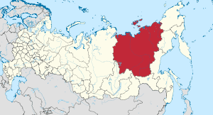 Sakha Republic in Russia | |||||||||||
 SUY Location of the airport in the Sakha Republic | |||||||||||
| Runways | |||||||||||
| |||||||||||
Suntar Airport (IATA: SUY, ICAO: UENS) is an airport, and possible former air base, serving and located 3 kilometres (1.9 mi) north of Suntar, Suntarsky District, in the Sakha Republic of Russia. It is a fairly extensive airfield. The large 300 metres (980 ft) long tarmac area suggests that it was used for deployments of attack or bomber aircraft into the Arctic regions.
There is also a Suntar Khayata mountain range on the Kolyma Highway.
Airlines and destinations
| Airlines | Destinations |
|---|---|
| Polar Airlines | Yakutsk |
References
- ↑ Airport information for UENS at Great Circle Mapper.
- ↑ Airport information for Suntar Airport at Search (for) Travel website.
This article is issued from Wikipedia - version of the 12/4/2016. The text is available under the Creative Commons Attribution/Share Alike but additional terms may apply for the media files.