Sunnyside, Washington
| Sunnyside, Washington | |
|---|---|
| City | |
|
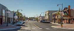
Edison Avenue | |
 Location of Sunnyside, Washington | |
| Coordinates: 46°19′15″N 120°0′44″W / 46.32083°N 120.01222°WCoordinates: 46°19′15″N 120°0′44″W / 46.32083°N 120.01222°W | |
| Country | United States |
| State | Washington |
| County | Yakima |
| Incorporated | 1902 |
| Government | |
| • Type | Council-Manager |
| • Manager | Donald Day (2013) |
| • Mayor | Jim Restucci (2013) |
| • Deputy Mayor | Dean Broersma (2016) |
| Area[1] | |
| • Total | 6.63 sq mi (17.17 km2) |
| • Land | 6.63 sq mi (17.17 km2) |
| • Water | 0 sq mi (0 km2) |
| Elevation | 745 ft (227 m) |
| Population (2010)[2] | |
| • Total | 15,858 |
| • Estimate (2015)[3] | 16,325 |
| • Density | 2,391.9/sq mi (923.5/km2) |
| Time zone | Pacific (PST) (UTC-8) |
| • Summer (DST) | PDT (UTC-7) |
| ZIP code | 98944 |
| Area code | 509 |
| FIPS code | 53-68750 |
| GNIS feature ID | 1531913[4] |
| Website | City of Sunnyside |
Sunnyside is a city in Yakima County, Washington, United States. As of the 2010 census the population was 15,858.
History

On September 16, 1902, residents voted 42 to one to incorporate as the town of Sunnyside. By state law a town needed to have 300 citizens in order to legally incorporate. With 314 residents, Sunnyside was just eligible to legally vote for incorporation.
The first mayor of Sunnyside was the town druggist James Henderson.
The settlement was originally founded by Walter Granger in 1893. The name "Sunnyside" was coined by a merchant named W. H. Cline. Granger was involved in the financing and construction of the Sunnyside Canal which would allow Yakima River water to irrigate the area. However, due to the Panic of 1893, Granger's creditors foreclosed on the canal, and the town's population dwindled to seven families. However, by the end of 1901, the population had doubled, finally exceeding 300 people. The townsite contained "1 bank, 11 stores, 3 hotels, 1 newspaper, 2 blacksmith shops, 2 livery barns, 3 churches, and a large and growing school."[5]
Sunnyside's population increase at this time was stimulated by the immigration of the Dunkards from South Dakota who were moving to the town. The population of Dunkards was of such notable size that by 1902 it was noted that they had "built a commodious place of worship at Sunnyside" which was the largest church in Yakima County at the time.[6]
The Dunkards, members of the German Baptist Progressive Brethren, relocated to Sunnyside in order to form what they called the Christian Cooperative Colony. The Brethren bought the entire town site and were the developers of its first bank, and a telephone system. They enforced clauses prohibiting alcohol, dancing, and gambling as a condition on every parcel of land sold. Because of this, old maps of Washington identify the town with a cross or halo symbol.
Later, in the 1930s, refugees from the Dust Bowl also moved to Sunnyside.[7]
Under the leadership of mayor William Bright "Billy" Cloud (1870–1959), Sunnyside initiated a project to pave its dirt streets on June 5, 1917. This project was necessary since years of irrigation had raised the water table to the point that the streets had become unbearably muddy. The cost of the entire project was $62,629.45.[8]
In 1948, Sunnyside became the first city in the State of Washington to adopt the Council-manager plan of government (see RCW 35A.13). This plan provides for an elected city council which is responsible for policy making, and a professional city manager, appointed by the council, who is responsible for administration. The city manager provides policy advice, directs the daily operations of city government, handles personnel functions (including the power to appoint and remove employees) and is responsible for preparing the city budget. Under the council-manager statutes, the city council is prohibited from interfering with the manager's administration. The city manager; however, is directly accountable to and can be removed by a majority vote of the council at any time.[9]
Sunnyside was awarded the distinction of being an All-America City in 1979.[10]
Attractions and events
Lighted Farm Implement Parade

First held in 1989, the 'Lighted Farm Implement Parade has been called "the NW's premier lighted parade."[11] Usually taking place in early December, the parade includes "farm implements: combines, boom trucks, sprayers, swathers, grape pickers, and all types of tractors" decorated with colorful lights.[12] The 2006 edition of the event had more than 70 parade entrants. The A&E network once named the event one of the "Top 10" such parades in the United States.[13] The parade was the first of its kind in the Yakima Valley.
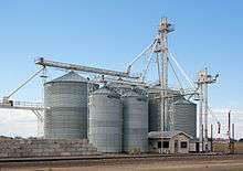
Darigold cheese factory
The Darigold Dairy Fair manufactures cheese, (150 million pounds of cheese annually)[14] but is mostly noted for its colorful facade and circus-like decorations, which include a pair of cows swinging on a flying trapeze.[15]
Sunnyside Historical Museum
Located downtown, the museum houses and displays artifacts and documents with a focus on daily life in Sunnyside during its early years.[16][17] The building housing the museum was donated to the city by Robert and Martha McIntosh, who had purchased the business from the family of Walter C. Ball & Sons, the local undertaking business. Both were also among the pioneering families that founded Sunnyside. The Sunnyside Memorial Cemetery, founded by the Ball Family, is located north of town. The lone structure at that location was designed by Percy Ball to resemble Chingford Church in Walthamstow, England where Walter C. Ball and his wife Amelia grew up together. This building was used to house the retort for cremations until it fell into disrepair. The family plots of the Ball family are located on the east side of the structure.[18]
Schools
Many of the original school buildings in Sunnyside, and the town of Outlook just northwest of town, have either burned to the ground or been demolished to make way for bigger and better structures. One of the original structures still in use is the Lincoln School Building which sits at the intersection of Lincoln and Sixth Street. Erected in 1927, it is a two story structure with an adjacent gymnasium attached to the east wing of the building. In 1928, female teachers were not allowed to marry. Doing so would void their contract to teach.[19]
The land that Lincoln School sits on was donated to the school district by H. Lloyd Miller in 1926. He and his wife later donated the land next to it between the school and 9th Ave. to be used for play fields for the students. Lincoln still remains as one of the oldest buildings in the school district. It has been remodeled and renovated to accommodate the administrative offices for the district. It also houses classrooms for kindergarten.[20]
Public schools
- Sunnyside High School
- Sierra Vista Middle School
- Harrison Middle School
- Chief Kamiakin Elementary School
- Pioneer Elementary School
- Washington Elementary School
- Sun Valley Elementary School
- Outlook Elementary School
- Lincoln School Building (Administration Bldg.)
Private schools
- Sunnyside Christian High School
- Sunnyside Christian Elementary School
- Calvary Lutheran Pre-School and Kindergarten
Libraries
Sunnyside has one public library. The original public library, a Carnegie Library, was built in 1911. It was replaced in 1964 with the current library building. It is the second largest library in the Yakima Valley Regional Library System and has one of the largest Spanish language collections in the system.[21]
Notable people
- Bonnie J. Dunbar, NASA astronaut. She graduated from Sunnyside High School in 1967.
- Kristina Guerrero, Inside Edition television correspondent.[22]
- Jake Kupp, former American football guard in the National Football League for the Dallas Cowboys, Washington Redskins, Atlanta Falcons, and the New Orleans Saints.
- Scott Linehan, former head coach of the NFL's St. Louis Rams (2006-2008). Born and raised in Sunnyside, he graduated from Sunnyside High School in 1982.
- Scott Meyer, author of the webcomic Basic Instructions.
- Jim Pomeroy, former professional motocross racer and first American to win a motocross world championship race (1973).
- Jens Pulver, a boxer and MMA fighter. He was the first UFC lightweight champion. Born in Sunnyside on December 6, 1974.
- Earl Smith, former outfielder for the Pittsburgh Pirates. Born in Sunnyside in 1928.
- Rob Thomas, creator of Veronica Mars. Born in Sunnyside in 1965.
- Faith Adiele, author of Meeting Faith: The Forest Journals of a Black Buddhist Nun, her autobiographical account of her time as Thailand's first Black Buddhist nun. She was born in Spokane but grew up in Sunnyside.
Judge David G. Estudillo, Grant County Superior Court Judge, graduated from Sunnyside High School in 1991.
Geography
Sunnyside is located at 46°19′15″N 120°0′44″W / 46.32083°N 120.01222°W (46.320798, -120.012232).[23]
According to the United States Census Bureau, the city has a total area of 6.63 square miles (17.17 km2), all of it land.[1]
Sunnyside lies approximately 180 miles away from Seattle to the west, Spokane to the east, and Portland to the southwest.[24]
Demographics
| Historical population | |||
|---|---|---|---|
| Census | Pop. | %± | |
| 1910 | 1,379 | — | |
| 1920 | 1,809 | 31.2% | |
| 1930 | 2,113 | 16.8% | |
| 1940 | 2,368 | 12.1% | |
| 1950 | 4,194 | 77.1% | |
| 1960 | 6,208 | 48.0% | |
| 1970 | 6,751 | 8.7% | |
| 1980 | 9,225 | 36.6% | |
| 1990 | 11,238 | 21.8% | |
| 2000 | 13,905 | 23.7% | |
| 2010 | 15,858 | 14.0% | |
| Est. 2015 | 16,325 | [25] | 2.9% |
| U.S. Decennial Census[26] 2015 Estimate[3] | |||
2010 census
As of the census[2] of 2010, there were 15,858 people, 4,332 households, and 3,428 families residing in the city. The population density was 2,391.9 inhabitants per square mile (923.5/km2). There were 4,556 housing units at an average density of 687.2 per square mile (265.3/km2). The racial makeup of the city was 43.4% White, 0.3% African American, 0.9% Native American, 0.7% Asian, 52.3% from other races, and 2.3% from two or more races. Hispanic or Latino of any race were 82.2% of the population.
There were 4,332 households of which 57.8% had children under the age of 18 living with them, 49.6% were married couples living together, 21.1% had a female householder with no husband present, 8.4% had a male householder with no wife present, and 20.9% were non-families. 17.0% of all households were made up of individuals and 8.6% had someone living alone who was 65 years of age or older. The average household size was 3.60 and the average family size was 4.02.
The median age in the city was 25 years. 38.5% of residents were under the age of 18; 11.4% were between the ages of 18 and 24; 26.4% were from 25 to 44; 15.3% were from 45 to 64; and 8.3% were 65 years of age or older. The gender makeup of the city was 50.1% male and 49.9% female.
2000 census
As of the census of 2000, there were 13,905 people, 3,827 households, and 3,000 families residing in the city. The population density was 2,340.4 people per square mile (903.8/km²). There were 4,070 housing units at an average density of 685.0 per square mile (264.6/km²). The racial makeup of the city was 42.61% White, 0.40% African American, 0.63% Native American, 0.69% Asian, 0.09% Pacific Islander, 52.58% from other races, and 3.01% from two or more races. Hispanic or Latino of any race were 73.05% of the population.
There were 3,827 households out of which 50.2% had children under the age of 18 living with them, 55.1% were married couples living together, 16.6% had a female householder with no husband present, and 21.6% were non-families. 18.6% of all households were made up of individuals and 11.0% had someone living alone who was 65 years of age or older. The average household size was 3.58 and the average family size was 4.02.
In the city the age distribution of the population shows 38.1% under the age of 18, 11.7% from 18 to 24, 26.6% from 25 to 44, 14.0% from 45 to 64, and 9.6% who were 65 years of age or older. The median age was 25 years. For every 100 females there were 99.0 males. For every 100 females age 18 and over, there were 94.7 males.
The median income for a household in the city was $27,583, and the median income for a family was $28,304. Males had a median income of $25,187 versus $25,779 for females. The per capita income for the city was $10,366. About 29.1% of families and 34.5% of the population were below the poverty line, including 46.2% of those under age 18 and 18.1% of those age 65 or over.
Climate
Sunnyside has a cold desert climate (BWk) according to the Köppen climate classification system.
| Climate data for Sunnyside | |||||||||||||
|---|---|---|---|---|---|---|---|---|---|---|---|---|---|
| Month | Jan | Feb | Mar | Apr | May | Jun | Jul | Aug | Sep | Oct | Nov | Dec | Year |
| Record high °F (°C) | 70 (21) |
72 (22) |
82 (28) |
96 (36) |
104 (40) |
107 (42) |
112 (44) |
108 (42) |
103 (39) |
89 (32) |
77 (25) |
69 (21) |
112 (44) |
| Average high °F (°C) | 38.9 (3.8) |
47.2 (8.4) |
58.1 (14.5) |
66.9 (19.4) |
75.1 (23.9) |
82.2 (27.9) |
90 (32) |
88.6 (31.4) |
79.5 (26.4) |
66.9 (19.4) |
50.5 (10.3) |
40 (4) |
65.3 (18.5) |
| Average low °F (°C) | 23 (−5) |
27 (−3) |
31.9 (−0.1) |
37.5 (3.1) |
44.8 (7.1) |
51 (11) |
54.7 (12.6) |
52.7 (11.5) |
45.8 (7.7) |
37.2 (2.9) |
30.1 (−1.1) |
25.3 (−3.7) |
38.4 (3.6) |
| Record low °F (°C) | −26 (−32) |
−19 (−28) |
7 (−14) |
4 (−16) |
24 (−4) |
32 (0) |
39 (4) |
36 (2) |
18 (−8) |
12 (−11) |
−23 (−31) |
−30 (−34) |
−30 (−34) |
| Average precipitation inches (mm) | 0.9 (23) |
0.62 (15.7) |
0.45 (11.4) |
0.47 (11.9) |
0.54 (13.7) |
0.54 (13.7) |
0.18 (4.6) |
0.25 (6.4) |
0.43 (10.9) |
0.58 (14.7) |
0.9 (23) |
0.93 (23.6) |
6.8 (173) |
| Average snowfall inches (cm) | 4.5 (11.4) |
1.8 (4.6) |
0.2 (0.5) |
0 (0) |
0 (0) |
0 (0) |
0 (0) |
0 (0) |
0 (0) |
0 (0) |
1.8 (4.6) |
4 (10) |
12.4 (31.5) |
| Average precipitation days | 7 | 6 | 5 | 4 | 5 | 4 | 2 | 2 | 3 | 5 | 7 | 8 | 58 |
| Source: [27] | |||||||||||||
References
- 1 2 "US Gazetteer files 2010". United States Census Bureau. Retrieved 2012-12-19.
- 1 2 "American FactFinder". United States Census Bureau. Retrieved 2012-12-19.
- 1 2 "Population Estimates". United States Census Bureau. Retrieved June 18, 2016.
- ↑ "US Board on Geographic Names". United States Geological Survey. 2007-10-25. Retrieved 2008-01-31.
- ↑ Sunnyside irrigation canal; Washington irrigation company, proprietor. Zillah, Washington: Washington Irrigation Company. 1902. p. 29.
- ↑ Sunnyside irrigation canal; Washington irrigation company, proprietor. Zillah, Washington: Washington Irrigation Company. 1902. p. 17.
- ↑ Sunnyside incorporates on September 16, 1902. HistoryLink.org Essay 5316
- ↑ Sunnyside begins paving its streets on June 5, 1917. HistoryLink.org Essay 8372
- ↑ http://www.mrsc.org/subjects/governance/trends.aspx
- ↑ "Past Winners of the All-America City Award (1970's)". Archived from the original on August 22, 2009. Retrieved 22 November 2009.
- ↑ Calendar of Events and Attractions for Yakima Valley
- ↑ Sunnyside Chamber of Commerce Press Release: Sunnyside's 19th Annual Lighted Farm Implement Parade
- ↑ "Sunnyside's lighted Christmas parade is an awesome display"
- ↑ Manufacturing page on Darigold website
- ↑ "Sunnyside cheese factory offers fun and fantasy, too"
- ↑ City of Sunnyside - Museum
- ↑ Museums, Heritage Centers, and Historical Societies in the Tri-Cities Washington Region
- ↑ Family genealogical records of Donald Malidore
- ↑ Sunnyside Museum and Historical Association, Chamber of Commerce Archives 1926-1928
- ↑ The Sunnyside Story. Sunnyside,WA: Sunnyside Museum and Historical Association. 1982. p. 144.
- ↑ Sunnyside Public Library web site
- ↑ "Kristina Guerrero and Megan Alexander Join 'Inside Edition' as New Correspondents". December 10, 2007. Retrieved 2008-09-10.
- ↑ "US Gazetteer files: 2010, 2000, and 1990". United States Census Bureau. 2011-02-12. Retrieved 2011-04-23.
- ↑ Sunnyside Chamber of Commerce. "About Sunnyside". Retrieved 8 January 2013.
- ↑ "Annual Estimates of the Resident Population for Incorporated Places: April 1, 2010 to July 1, 2015". Retrieved July 2, 2016.
- ↑ United States Census Bureau. "Census of Population and Housing". Retrieved July 21, 2014.
- ↑ "SUNNYSIDE, WASHINGTON (458207)". Western Regional Climate Center. Retrieved November 18, 2015.
External links
Municipalities and communities of Yakima County, Washington, United States | ||
|---|---|---|
| Cities | 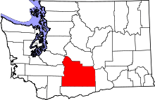 | |
| Towns | ||
| CDPs | ||
| Other unincorporated communities | ||
| Indian reservation | ||
| Footnotes | ‡This populated place also has portions in an adjacent county or counties | |