Summerville, South Carolina
| Summerville, South Carolina | |
|---|---|
| Town | |
| Motto: Sacra Pinus Esto ("The Pine is Sacred") | |
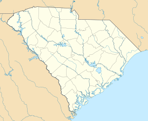 Summerville, South Carolina Location of Summerville, South Carolina | |
| Coordinates: 33°0′29″N 80°10′58″W / 33.00806°N 80.18278°WCoordinates: 33°0′29″N 80°10′58″W / 33.00806°N 80.18278°W | |
| Country | United States |
| State | South Carolina |
| Counties | Dorchester, Berkeley, Charleston |
| Government | |
| • Mayor | W. Wiley Johnson |
| Area | |
| • Total | 18.1 sq mi (47.0 km2) |
| • Land | 18.0 sq mi (46.7 km2) |
| • Water | 0.1 sq mi (0.3 km2) |
| Elevation | 89 ft (27 m) |
| Population (2016) | |
| • Total | 50,730 |
| • Density | 2,405/sq mi (928.5/km2) |
| Time zone | Eastern (EST) (UTC-5) |
| • Summer (DST) | EDT (UTC-4) |
| ZIP codes | 29483-29485 |
| Area code(s) | 843 |
| FIPS code | 45-70270[1] |
| GNIS feature ID | 1251073[2] |
| Website |
www |
Summerville is a town in the U.S. state of South Carolina situated mostly in Dorchester County with small portions in Berkeley and Charleston counties. It is part of the Charleston-North Charleston-Summerville Metropolitan Statistical Area. The population of Summerville at the 2010 census was 43,392,[3] and the estimated population was 44,719 as of July 1, 2013.
Geography
The center of Summerville is in southeastern Dorchester County; the town extends northeast into Berkeley and Charleston counties. It is bordered to the east by the town of Lincolnville and to the southeast by the city of North Charleston. The Summerville town limits extend south as far as the Ashley River next to Old Fort Dorchester State Historical Park.
U.S. Route 78 passes near the center of Summerville, leading southeast 24 miles (39 km) to downtown Charleston and northwest 29 miles (47 km) to Interstate 95 at St. George. Interstate 26 leads through the northeast corner of Summerville with access from Exit 199, leading southeast to Charleston and northwest 90 miles (140 km) to Columbia.
According to the United States Census Bureau, the town has a total area of 18.1 square miles (47.0 km2), of which 18.0 square miles (46.7 km2) is land and 0.12 square miles (0.3 km2), or 0.62%, is water.[3]
Demographics
| Historical population | |||
|---|---|---|---|
| Census | Pop. | %± | |
| 1880 | 1,371 | — | |
| 1890 | 2,219 | 61.9% | |
| 1900 | 2,420 | 9.1% | |
| 1910 | 2,355 | −2.7% | |
| 1920 | 2,550 | 8.3% | |
| 1930 | 2,579 | 1.1% | |
| 1940 | 3,023 | 17.2% | |
| 1950 | 3,312 | 9.6% | |
| 1960 | 3,633 | 9.7% | |
| 1970 | 3,839 | 5.7% | |
| 1980 | 6,492 | 69.1% | |
| 1990 | 22,519 | 246.9% | |
| 2000 | 27,752 | 23.2% | |
| 2010 | 43,392 | 56.4% | |
| Est. 2015 | 48,848 | [4] | 12.6% |
| U.S. Decennial Census | |||
As of the census[1] of 2010, there were 43,392 people residing in 16,181 households in the town. The population density of Summerville is 2,404.7 inhabitants per square mile. The racial makeup of the town was 72.1% White, 21.4% Black or African American, 0.4% Native American, 1.5% Asian, 0.1% Pacific Islander, 1.6% from other races, and 2.9% from two or more races. Hispanic or Latino of any race were 5.0% of the population.
There were 16,181 households out of which 38.6% had children under the age of 18 living with them, 48.9% were married couples living together, 15.4% had a female householder with no husband present, and 31.0% were non-families. 25.3% of all households were made up of individuals and 8.8% had someone living alone who was 65 years of age or older. The average household size was 2.55.
In the town, 27.0% of the population was under the age of 18, and 10.5% was 65 years of age or older. The median age was 34.7 years.
The median income for a household in the town was $54,677. About 11.2% of the population was below the poverty line. The median value of an owner-occupied home was $182,000.
The town has an abundance of affordable houses and lower taxes than cities such as Charleston and North Charleston, and has thus experienced rapid population growth. In 2007, it was designated a principal city of the Charleston–North Charleston–Summerville Metropolitan Statistical Area[5] Summerville is also included as part of the Charleston-North Charleston Urbanized area. Dorchester School District Two is the school district for Summerville and the wider area, and is based in the town.
History

The first settlement in Summerville began following the American Revolutionary War; it was referred to as Pineland Village in 1785. Development in the area resulted from plantation owners who resided in the Charleston area, and who came to Summerville to escape seasonal insects and swamp fever.[6]
Summerville became an official town in 1847. In that year, the town passed a law against cutting down trees of particular sizes, the first of such laws in the United States, and a $25 fine was issued upon any who did so without permission. Today, the motto upon the town's official seal reads "Sacra Pinus Esto (The Pine is Sacred)." [7]
In 1899, the International Congress of Physicians (or "Tuberculosis Congress"[6]) listed Summerville to be one of the two best areas in the world for treatment and recovery of lung and throat disorders. It received such notation due to its dry and sandy location, and the many pine trees in the area that release turpentine derivatives into the air. This notation is credited with aiding the commercial and residential development of Summerville.[7]
The Ashley River Road, Middleton Place, Colonial Dorchester State Historic Site, Old White Meeting House Ruins and Cemetery, and the Summerville Historic District are listed on the National Register of Historic Places.[8]
Tourism
Starting in 1973, the town of Summerville has hosted the annual Flowertown Festival. It is the largest arts and crafts festival in South Carolina. It is held the first weekend of April in the Summerville Azalea Park. In 1925, these flowers led Summerville's Chamber of Commerce to adopt the slogan "Flower Town in the Pines."
Although Summerville claims to be "The Birthplace of Sweet Tea," this is actually false. Their declaration of being the first place to have sweet tea comes from a perceived notion that a receipt from 1890 containing "600 pounds of sugar and 880 gallons of iced tea" is enough to give themselves the title of "The Birthplace of Sweet Tea." However, the oldest known recipe for sweet iced tea was published in 1879 in a community cookbook called Housekeeping in Old Virginia by Marion Cabell Tyree, who was born in Texas.
Climate
| Climate data for Summerville, South Carolina (Airport), 1981–2010 normals | |||||||||||||
|---|---|---|---|---|---|---|---|---|---|---|---|---|---|
| Month | Jan | Feb | Mar | Apr | May | Jun | Jul | Aug | Sep | Oct | Nov | Dec | Year |
| Average high °F (°C) | 59.0 (15) |
62.8 (17.1) |
69.6 (20.9) |
76.5 (24.7) |
83.2 (28.4) |
88.4 (31.3) |
91.1 (32.8) |
89.6 (32) |
84.9 (29.4) |
77.1 (25.1) |
69.8 (21) |
61.6 (16.4) |
76.1 (24.5) |
| Average low °F (°C) | 38.1 (3.4) |
41.2 (5.1) |
47.2 (8.4) |
53.8 (12.1) |
62.4 (16.9) |
70.2 (21.2) |
73.6 (23.1) |
72.9 (22.7) |
67.8 (19.9) |
57.3 (14.1) |
48.1 (8.9) |
40.6 (4.8) |
56.1 (13.4) |
| Average precipitation inches (mm) | 3.70 (94) |
2.96 (75.2) |
3.71 (94.2) |
2.91 (73.9) |
3.02 (76.7) |
5.64 (143.3) |
6.52 (165.6) |
7.15 (181.6) |
6.10 (154.9) |
3.75 (95.3) |
2.43 (61.7) |
3.11 (79) |
50.99 (1,295.1) |
| Average snowfall inches (cm) | 0.1 (0.3) |
0.2 (0.5) |
0 (0) |
0 (0) |
0 (0) |
0 (0) |
0 (0) |
0 (0) |
0 (0) |
0 (0) |
0 (0) |
0.3 (0.8) |
0.6 (1.5) |
| Average precipitation days (≥ 0.01 in) | 9.5 | 8.6 | 7.9 | 7.7 | 7.8 | 11.9 | 13.0 | 13.2 | 10.0 | 7.3 | 7.0 | 8.7 | 112.6 |
| Average snowy days (≥ 0.1 in) | 0.1 | 0.1 | 0 | 0 | 0 | 0 | 0 | 0 | 0 | 0 | 0 | 0.2 | 0.4 |
| Mean monthly sunshine hours | 179.8 | 189.3 | 244.9 | 276.0 | 294.5 | 279.0 | 288.3 | 257.3 | 219.0 | 223.2 | 189.0 | 170.5 | 2,810.8 |
| Source: NOAA,[9] HKO (sun only, 1961–1990)[10] | |||||||||||||
Mayor
- Edward L. Hutchinson (1848-1863)
- James Gadsden (1863-1867)
- Robert Ilderton Limehouse (1867-69)
- Robert A. Pringle (1869)
- Benjamin C. Pressley (1870)
- Peter K. Coburn (1871)
- J. Hall Waring (1872)
- Terence R. Tighe (1873)
- E. Scott Miles (1874)
- Edward J. Limehouse (1875)
- James E. Burke (1876)
- George Tupper (1877-79)
- Jennings W. Perry (1879-85)
- John Henry Averill (1889-91)
- William H. Richardson (1893-1897, 1899-1901, 1913-23, 1929-32)
- Oscar E. Johnston,Jr. (1897-98)
- Henry P. Foster (1898-99)
- George Tupper, Jr. (1901-03)
- F. Julian Carroll (1903-05)
- Daniel Miler (1905-07)
- Orrin C. Sires (1907-09)
- S. Lewis Simons (1909-13)
- Edward E. Cauthen (1923-24)
- Herbert H. Jessen (1925-28)
- Grange Simons Cuthbert (1932-47)
- Albert Henry Peters (1947-53)
- L. Hayden Doty (1953-65)
- William L. Sullivan (1965)
- Alan L. Luke (1965-72)
- Berlin G. Myers (1972-2011)
- William C. Collins (2011-2016)
- W. Wiley Johnson (2016- )
Town Clerk and Treasurer
- William Russell Dehon (1890-97)
- George Tupper (1897-1908)
- Edward E. Cauthen (1908-19)
- W.R. Mayer (1919-20)
- E.P. Lawton (1920-31)
- Hugh Hamilton (1931-45)
- Sanford B. Stoney (1945-66)
- Robert Faires (1966-68)
- Richard D. Mellette (1968-71)
- Fred Ballard (1971-74)
- J. Gordon Jenkins, Jr. (1974-79)
- Gerald E. Blackwell (Interim) (1979)
- John F. Wilbanks (1979-94)
- Kara Silva (1994-96)
- Lisa L. Wallace (1996- )
Town Administrator
- John F. Wilbanks (1981-2001)
- Mark Williams (2001-2004)
- Lisa L. Wallace (Interim) (2004-05, 2011, 2015-16)
- Dennis P. Pieper (2005-2011)
- Colin L. Martin (2016- )
Corporation Counsel
- James E. Burke (1894-97)
- Terence R. Tighe (1897-1900)
- Legare Walker (1900-01, 1903-52)
- Jennings W. Perry, Jr.(1901-03)
- Legare Walker, Jr. (1952-53, 1967-71)
- Sidney B. Jones, Jr. (1953-67, 1971-77)
- Walter M. Bailey, Jr. (1977-1993)
- John Hamilton Smith (1993-99)
- Troy Guerard Knight (1999-2004)
- Kelly Knight (2004-07)
- D. Mark Stokes (2007-2011)
- G. Waring Parker (2011- )
Notable people
- Rick Brewer, former administrator at Charleston Southern University in North Charleston, South Carolina, and current president of Louisiana College in Pineville, Louisiana, former resident of Summerville[11][12]
- Janet Cone, college athletic director (UNC Asheville Bulldogs) and former basketball coach
- Chuck Eidson, professional basketball player
- Brett Gardner, baseball player for the New York Yankees
- A. J. Green, 5-time NFL Pro Bowl wide receiver for the Cincinnati Bengals
- Milton Jennings, professional basketball player
- John McKissick, high school football coach, winningest football coach at any level
- Fern Michaels, author
- Berlin G. Myers Mayor of 40 years
- Yvette Russell-BowersUS Army Sergeant Major Retired
References
- 1 2 "American FactFinder". United States Census Bureau. Retrieved 2008-01-31.
- ↑ "US Board on Geographic Names". United States Geological Survey. 2007-10-25. Retrieved 2008-01-31.
- 1 2 "Geographic Identifiers: 2010 Demographic Profile Data (G001): Summerville town, South Carolina". U.S. Census Bureau, American Factfinder. Retrieved April 7, 2014.
- ↑ "Annual Estimates of the Resident Population for Incorporated Places: April 1, 2010 to July 1, 2014". Retrieved June 4, 2015.
- ↑ "Update of Statistical Area Definitions and Guidance on Their Uses (OMB Bulletin 08 - 01)" (PDF). Office of Management and Budget, Executive Office of the President. November 20, 2007. Retrieved 2008-11-19.
- 1 2 Historic Facts About Summerville & Dorchester County
- 1 2 Summerville's Book of History
- ↑ National Park Service (2009-03-13). "National Register Information System". National Register of Historic Places. National Park Service.
- ↑ "NowData – NOAA Online Weather Data". National Oceanic and Atmospheric Administration. Retrieved 2012-02-12.
- ↑ "Climatological Normals of Charleston, South Carolina". Hong Kong Observatory. Retrieved 2010-06-09.
- ↑ Leigh Guidry (March 25, 2015). "LC board names South Carolina VP as ninth president". The Alexandria Town Talk. Retrieved July 23, 2015.
- ↑ "Richard B. Brewer". intelius.com. Retrieved July 23, 2015.
External links
- Town of Summerville official website
- Summerville D.R.E.A.M. (Downtown Restoration, Enhancement and Management)
- Summerville & Dorchester County's Official Tourism Site
- Azalea Magazine (Modern Living in the Old South, Summerville's magazine)
Municipalities and communities of Berkeley County, South Carolina, United States | ||
|---|---|---|
| Cities | 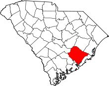 | |
| Towns | ||
| CDPs | ||
| Other unincorporated communities | ||
| Footnotes | ‡This populated place also has portions in an adjacent county or counties | |
Municipalities and communities of Charleston County, South Carolina, United States | ||
|---|---|---|
| Cities | 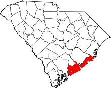 | |
| Towns | ||
| CDP | ||
| Unincorporated communities | ||
| Footnotes | ‡This populated place also has portions in an adjacent county or counties | |
Municipalities and communities of Dorchester County, South Carolina, United States | ||
|---|---|---|
| City | 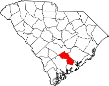 | |
| Towns | ||
| Unincorporated community | ||
| Ghost town | ||
| Footnotes | ‡This populated place also has portions in an adjacent county or counties | |