Summerhill, New York
| Summerhill, New York | |
|---|---|
| Town | |
|
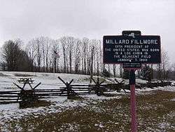
Millard Fillmore's birthplace | |
 Location within Cayuga County and New York | |
 Summerhill Location within the state of New York | |
| Coordinates: 42°39′21″N 76°18′27″W / 42.65583°N 76.30750°W | |
| Country | United States |
| State | New York |
| County | Cayuga |
| Government | |
| • Type | Town Council |
| • Town Supervisor | Charles Ripley (R) |
| • Town Council |
Members' List
|
| Area | |
| • Total | 26.0 sq mi (67.3 km2) |
| • Land | 25.9 sq mi (67.0 km2) |
| • Water | 0.1 sq mi (0.3 km2) |
| Elevation | 1,660 ft (506 m) |
| Population (2010) | |
| • Total | 1,217 |
| • Density | 47.1/sq mi (18.2/km2) |
| Time zone | Eastern (EST) (UTC-5) |
| • Summer (DST) | EDT (UTC-4) |
| FIPS code | 36-72037 |
| GNIS feature ID | 0979536 |
| Website |
www |
Summerhill is a town in Cayuga County, New York, United States. The population was 1,217 at the 2010 census.[1] The town name is that of a location in Ireland. Summerhill is in the southeast corner of the county and is northeast of Ithaca.
History
Prior to the American Revolution, this area was part of the territory of the Onondaga people. Afterwards, Summerhill was part of the Central New York Military Tract, land reserved for veterans. The first settler arrived around 1797.
The town was founded as the town of Plato in 1831 from the town of Locke, but the name was changed to "Summerhill" in 1832 to avoid conflict with the name of another location.
Much of the town was re-forested by the Civilian Conservation Corps in the 1930s.
Geography
According to the United States Census Bureau, the town has a total area of 26.0 square miles (67.3 km2), of which 25.9 square miles (67.0 km2) is land and 0.12 square miles (0.3 km2), or 0.47%, is water.[1]
The south town line is the border of Tompkins County, and the east town line is the border of Cortland County.
New York State Route 90 is an east-west highway in south of Summerhill. New York State Route 41A crosses the northeast part of the town.
Adjacent towns and areas
The town of Sempronius is to the north, and the town of Locke is to the west. The town of Groton in Tompkins County is on the south, and the town of Homer in Cortland County is on the east.
Demographics
| Historical population | |||
|---|---|---|---|
| Census | Pop. | %± | |
| 1840 | 1,446 | — | |
| 1850 | 1,251 | −13.5% | |
| 1860 | 1,194 | −4.6% | |
| 1870 | 1,036 | −13.2% | |
| 1880 | 1,028 | −0.8% | |
| 1890 | 864 | −16.0% | |
| 1900 | 779 | −9.8% | |
| 1910 | 613 | −21.3% | |
| 1920 | 539 | −12.1% | |
| 1930 | 448 | −16.9% | |
| 1940 | 505 | 12.7% | |
| 1950 | 542 | 7.3% | |
| 1960 | 667 | 23.1% | |
| 1970 | 670 | 0.4% | |
| 1980 | 850 | 26.9% | |
| 1990 | 1,017 | 19.6% | |
| 2000 | 1,098 | 8.0% | |
| 2010 | 1,217 | 10.8% | |
| Est. 2014 | 1,193 | [2] | −2.0% |
As of the census[4] of 2000, there were 1,098 people, 393 households, and 304 families residing in the town. The population density was 42.4 people per square mile (16.4/km²). There were 463 housing units at an average density of 17.9 per square mile (6.9/km²). The racial makeup of the town was 99.27% White, 0.18% African American, 0.18% Native American, and 0.36% from two or more races. Hispanic or Latino of any race were 0.64% of the population.
There were 393 households out of which 37.4% had children under the age of 18 living with them, 60.3% were married couples living together, 7.9% had a female householder with no husband present, and 22.6% were non-families. 16.0% of all households were made up of individuals and 6.1% had someone living alone who was 65 years of age or older. The average household size was 2.79 and the average family size was 3.06.
In the town the population was spread out with 29.2% under the age of 18, 7.6% from 18 to 24, 30.1% from 25 to 44, 23.8% from 45 to 64, and 9.3% who were 65 years of age or older. The median age was 36 years. For every 100 females there were 105.2 males. For every 100 females age 18 and over, there were 105.0 males.
The median income for a household in the town was $39,000, and the median income for a family was $39,500. Males had a median income of $26,336 versus $24,375 for females. The per capita income for the town was $14,609. About 6.9% of families and 12.1% of the population were below the poverty line, including 21.8% of those under age 18 and 2.0% of those age 65 or over.
Notable people
- Millard Fillmore (1800–1874), 13th President of the United States, 12th Vice President of the United States and last member of the Whig Party to be president
- William H. Peters, member of the Wisconsin State Assembly
- Elbridge G. Spaulding, congressman, mayor of Buffalo, New York, and treasurer of New York
Communities and locations in Summerhill
- Como – A hamlet in the northeast part of the town on NY Route 41A.
- Empire Haven Nudist Park – Host of the Northeast Naturist Festival.
- Fall Creek – A stream flowing southward in the eastern part of Summerhill. The creek joins Cayuga Lake in Ithaca.
- Fillmore Glen State Park – The state park in the northwest of the town (and in the town of Locke) contains a replica of Millard Fillmore's birthplace.
- Four Town Corners – A location in the northwest corner of the town.
- Halls Corners – A hamlet on the east side of the town on NY Route 90, east of Summer Hill.
- Lake Como (formerly "Locke Pond") – A small lake west of the community of Como.
- Summer Hill – The hamlet of Summer Hill is in the south part of the town on NY-90.
References
- 1 2 "Geographic Identifiers: 2010 Demographic Profile Data (G001): Summerhill town, Cayuga County, New York". U.S. Census Bureau, American Factfinder. Retrieved November 14, 2014.
- ↑ "Annual Estimates of the Resident Population for Incorporated Places: April 1, 2010 to July 1, 2014". Retrieved June 4, 2015.
- ↑ "Census of Population and Housing". Census.gov. Retrieved June 4, 2015.
- ↑ "American FactFinder". United States Census Bureau. Retrieved 2008-01-31.
External links
Coordinates: 42°38′21″N 76°19′31″W / 42.63917°N 76.32528°W
Municipalities and communities of Cayuga County, New York, United States | ||
|---|---|---|
| City |  | |
| Towns | ||
| Villages | ||
| CDP | ||
| Other hamlets | ||
| Footnotes | ‡This populated place also has portions in an adjacent county or counties | |