Sulhamstead
| Sulhamstead | |
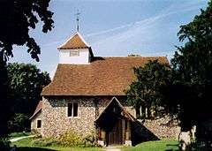 St.Mary's Church, Sulhamstead Abbots |
|
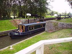
 Sulhamstead Tyle Mill wharf |
|
 Sulhamstead |
|
| Area | 7.08 km2 (2.73 sq mi) |
|---|---|
| Population | 1,471 (2011 census)[1] |
| – density | 208/km2 (540/sq mi) |
| OS grid reference | SU6369 |
| Civil parish | Sulhamstead |
| Unitary authority | West Berkshire |
| Ceremonial county | Berkshire |
| Region | South East |
| Country | England |
| Sovereign state | United Kingdom |
| Post town | READING |
| Postcode district | RG23 |
| Dialling code | 0118 |
| Police | Thames Valley |
| Fire | Royal Berkshire |
| Ambulance | South Central |
| EU Parliament | South East England |
| UK Parliament | Wokingham |
Coordinates: 51°24′47″N 1°05′24″W / 51.413°N 1.090°W
Sulhamstead is a village and civil parish in West Berkshire, England. It occupies an approximate rectangle of land[n 1] south of the (Old) Bath Road (A4) between Reading, its nearest town and Thatcham. It has several small clusters of homes and woodland covering about a fifth of the land, in the centre and north beside which is Thames Valley Police's main Training Centre at Sulhamstead House. Its main amenities are its Church of England parish church and a shop and visitor centre by the Kennet & Avon Canal.
Geography
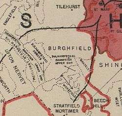
Sulhamstead's immediate neighbours toward its northern border, the A4 road, are much more populous Theale which has the nearest Theale and shops and similarly low density Ufton Nervet. Across this road is very low population and housing density Englefield.
A dispersed village, it has five clusters of homes. The greatest of these is linear, on Sulhamstead Hill (road) from the top of the hill by Ufton Church down 1 mile (1.6 km) to the water meadows by the Kennet and the Bath Road (A4). Three further developed points are diminutive Sulhamstead Abbots, Whitehouse Green and Sulhamstead Bannister. Lastly the northwestern corner of Burghfield Common village is in the far south, the remainder of the village part of Burghfield.
Sulhamstead Abbots Church, St Mary's, to the south, is the active ecclesiastical parish church. Sulhamstead Bannister forms the narrowly buffered halves: "Upper End" and "Lower End". Upper End is between Wokefield and Grazeley, although this has since been absorbed into Wokefield civil parish. The core of its village was around the old demolished church, where the inventor Samuel Morland's father was once the vicar.
Before 1782, Sulhamstead consisted of two ecclesiastical parishes, Sulhamstead Abbots and Sulhamstead Bannister, approximate to the boundaries of the manors of the same name before medieval and later subdivision.
History
The name Sulhamstead means 'Narrow Valley Homestead' and was given to the area by the first Saxon settlers. There is supposed to have been a Danish Camp of some sort there during the troubled times just before and during King Alfred's reign.[2]
Ban(n)ister was the name of the Lords of the Manor from the early 12th century. They were still holding lands here three hundred years later, and had another important manor in Finchampstead. The Upper End was, however, often called Meales and Meales Farm, a reputed manor, stands next to the site of the Church of St. Michael from which its name derives.[2]
A congregational chapel/church was built in 1881 in place of an older chapel. The inclosure of the two parishes of Sulhamstead Abbots and Sulhamstead Bannister was made by Act of Parliament, effective 1817.[3]
Grazeley was a tithing in the parish of Sulhamstead Abbots containing of 519 acres (2.10 km2). In 1854, when the manorial estate of Grazeley was advertised for sale, it was inclosed in a ring fence and apparently included the whole tithing.[3]
Landmarks
Sulhamstead House
Sulhamstead House, commonly known as the White House, was the manor house of Sulhamstead Abbots. It was built by Daniel May, son of the Basingstoke brewer, Charles May, in 1744, becoming home to his sister's descendants, the Thoyts family. The house was largely rebuilt in 1800 for William Thoyts, the High Sheriff of Berkshire. It was the childhood home of his great granddaughter, Berkshire historian and palaeographer, Emma Elizabeth Thoyts (1860–1949).[4] It refurbishment was paid for in 1910 by William G Watson, created a baronet (territorial designation: of Sulhamstead). The baronetcy is extinct. In 1949, the house became the headquarters of the Berkshire Constabulary. Since their merger into Thames Valley Police, it has functioned as that force's training centre and houses the Thames Valley Police Museum. It is a Grade II listed building.[5]
Folly Farm
This was built around a small timber-framed cottage dating to around 1650, which was gradually enlarged into a farm house and now survives as a small wing of the house. The house was transformed in 1906 by Arts and Crafts architect Edwin Lutyens into a country home for H. H. Cochrane. It was extended, by Lutyens, for Zachary Merton, six years later. It is one of Lutyens' best-known house designs. Lutyens collaborated with Gertrude Jekyll to make the diverse, multi-level garden. Folly Farm is Grade I listed, being the highest category, as it is an exceptional example of Arts and Craft architecture.[2]
Other buildings

The church of St Mary (formerly St Bartholomew) dates from the 13th century and is Grade I listed.[6]
The active village hall for Sulhamstead and Ufton is halfway down the road Sulhamstead Hill, built in 1927.
Sulhamstead Lock, Tyle Mill and Tyle Mill Lock on the Kennet & Avon Canal have a wharf, lock and swing bridge. The singer-songwriter Kate Bush live in a large canalside home for several years until 2004.
Omer's Gully
Omer's Gully Wood is next to the north-west corner of more populous Burghfield Common village. The most part is owned by the Englefield (Manor) Estate and the remainder by the Local Authority. The wood covers 3.6 hectares. The woodland has been well coppiced for firewood in the past. 86 different plant species and 46 different birds have been found and it is a recorded habitat for mammals including foxes, deer, badgers, squirrels and rabbits.[7] The woodland links up with other woodland by Omers Brook, such as Clayhill Copse to the north east as part of a larger natural woodland covered habitat.
Demography
| Output area | Homes owned outright | Owned with a loan | Socially rented | Privately rented | Other | km² roads | km² water | km² domestic gardens | Usual residents | km² |
|---|---|---|---|---|---|---|---|---|---|---|
| Civil parish | 134 | 210 | 144 | 73 | 14 | 0.193 | 0.221 | 0.299 | 1471 | 7.08 |
Notable people
- Florence Nagle (1894 – 1988), race horse and dog breeder
Notes and references
- Notes
- ↑ With a short, half-width south-west projection, west of Burghfield.
- References
- 1 2 Key Statistics: Dwellings; Quick Statistics: Population Density; Physical Environment: Land Use Survey 2005
- 1 2 3 David Nash Ford's royal Berkshire History: Sulhamstead Retrieved 2014-12-16.
- 1 2 'Parishes: Sulhamstead Abbots with Grazeley', A History of the County of Berkshire: Volume 3 ed. P H Ditchfield and William Page (London, 1923), pp. 306-311
- ↑ Ford, David Nash. "Sulhamstead House". May Family History. Retrieved 16 September 2006.
- ↑ "Thames Valley Police Training College (Sulhamstead House)". Images of England. Retrieved 16 September 2006.
- ↑ "Church of St. Mary". Images of England. Retrieved 16 September 2006.
- ↑ Friends of Omer's Gully Wood Retrieved 2014-12-16.
Swing bridge gallery
 Sulhamstead Tyle Mill swing bridge road traffic
 Sulhamstead Tyle Mill swing bridge opening
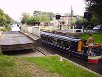 Sulhamstead Tyle Mill swing bridge canal traffic
External links
| Wikimedia Commons has media related to Sulhamstead. |