Sulejów
| Sulejów | ||
|---|---|---|
|
Abbey | ||
| ||
 Sulejów | ||
| Coordinates: 51°21′10″N 19°53′5″E / 51.35278°N 19.88472°E | ||
| Country |
| |
| Voivodeship | Łódź | |
| County | Piotrków | |
| Gmina | Sulejów | |
| Government | ||
| • Mayor | Stanisław Baryła | |
| Area | ||
| • Total | 26.25 km2 (10.14 sq mi) | |
| Population (2006) | ||
| • Total | 6,387 | |
| • Density | 240/km2 (630/sq mi) | |
| Time zone | CET (UTC+1) | |
| • Summer (DST) | CEST (UTC+2) | |
| Postal code | 97-330 | |
| Car plates | EPI | |
| Website | http://www.sulejow.pl | |

Sulejów [suˈlɛjuf] is a town in central Poland with 6,375 inhabitants (2004). It is situated in Łódź Voivodeship (since 1999), having previously been in Piotrków Voivodeship (1975–1998). Sulejów gives its name to the protected area known as Sulejów Landscape Park.
The town was partially destroyed by the Luftwaffe in September 1939, causing more than 1000 deaths,[1][2]
History
The origins of Sulejów are associated with a village founded near the crossing of the Pilica river in the 12th century. The castle, which later sparked the development of a Cistercian abbey, was built between 1176 and 1177, on the orders of Duke Casimir II the Just. The abbey was constructed in the place which is now called Podklasztorze. The town received its civic rights in the middle of the 13th century, during the reign of King Władysław I the Elbow-high.
A great event in the history of the town was a rally, which took place between 20 and 23 of June, 1318. This rally was the official ceremony of adopting and enacting the papal conditions and the resumption of the Polish Kingdom. A permission request was sent to Pope John XXII for the coronation of Władysław I the Elbow-high. Later Bishop Gerward of Kujawy, was sent to Avignion for negotiations.
Sulejów used to be located on the trade routes between Silesia, Wielkopolska and the Kievan Rus'. In 1410 the Cistercian abbey was one of the stopping places for the Polish army, led by King Władysław II Jagiełło.
The damage of the Swedish invasions during the Deluge caused the collapse of the city. In 1819, the Cistercian monastery was closed and Sulejów became a village under another city's government. Later the city lost the control over the village and since 1912, Sulejów was a separate town, but still having no civic rights. In 1927 it regained the status of a city, which has contributed to its faster development.
Further destruction of the city occurred on 4 September 1939, during the Nazi Luftwaffe bombing. As a result, 80% of the buildings, including the Old Town, were destroyed. That day almost 1000 people lost their lives.
After World War II, the city was partially rebuilt. In 1986 the Cistercians returned to the newly reopened monastery.
Gallery
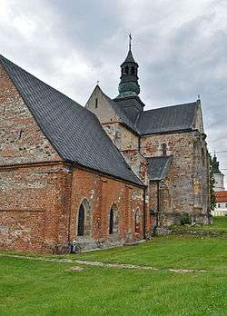
 Saint Thomas of Canterbury church in the Cistercian Abbey.
_by_Ron.jpg) Monastery
Monastery_by_Ron.jpg) 19th-century fire station which still operates today
19th-century fire station which still operates today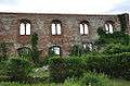 Ruins from World War II
References
- ↑ Martin Gilbert The Holocaust Fontana, 1990 ISBN 0-00-637194-9 Page 85
- ↑ History of Sulejów
| Wikimedia Commons has media related to Sulejów. |
Coordinates: 51°21′10″N 19°53′05″E / 51.35278°N 19.88472°E