Subcarpathia
Subcarpathia (Polish: Podkarpacie, Ukrainian: Прикарпаття (Prykarpattia) , Czech: Vněkarpatské sníženiny, German: Karpatenvorland denotes the depression area at the outer (western, northern and eastern) base of the Carpathian arc. It stretches from Austria to the Czech Republic, Poland, Ukraine, and Romania. The opposite lowland plain inside the Carpathians is called the Pannonian Basin.
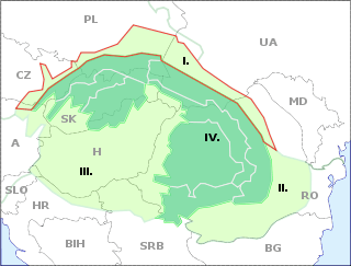
Geography
The western end is marked by the (northern) Vienna Basin, separating it from the Eastern Alpine Foreland. The adjacent hilly landscape of the Lower Austrian Weinviertel region with its extensive loess layers border on the limestone rock formations of the South-Moravian Carpathians.
In the Czech Republic, the depression is situated on the outskirts of the White Carpathians in Moravia, including the Pálava Protected Landscape Area. In Poland they stretch along the Lesser Poland Voivodeship to the Podkarpackie Voivodeship, part of the Galicia historic region that leads to Ukraine (Lviv, Ivano-Frankivsk and Chernivtsi Oblast) and the Dniester Basin.
In Romania, the depression ends east of the Carpathian arc on the upper Moldova River within the Bukovina and Moldavia regions, bordering on the Wallachian Plain in the south.
See also
- Moravian Gate
- Vyškov Gate
- Dyje-Svratka Vale
- Prykarpattia (Ciscarpathia) in Ukraine, as distinct from Zakarpattia (Transcarpathia)
- Podkarpackie Voivodeship, in south-eastern Poland (modern and historical region)
- Podkarpackie (European Parliament constituency)
- Carpatho-Ukraine (Ukrainian: Prykarpattia), a historical region of western Ukraine that stretches along the eastern edge of the Carpathian mountains. It is normally identified with Zakarpattia Oblast of western Ukraine.
- Carpathian Ruthenia - region in Central Europe, now mostly in western Ukraine's Zakarpattia Oblast, East Slovakia, Poland's Lemkovyna and Romanian Maramureş.
- Carpathia (disambiguation)
- Transcarpathia (disambiguation)