Storrow Drive
|
James Jackson Storrow Drive David G. Mugar Way | |
 | |
| Maintained by | Massachusetts DCR |
|---|---|
| Length |
1.98 mi (3.19 km) as Storrow Drive |
| West end | Soldiers Field Road in Fenway–Kenmore |
| Major junctions |
|
| East end |
|
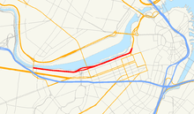
Storrow Drive is a major crosstown parkway in Boston, Massachusetts, running east and north along the Charles River to Leverett Circle.[1] It is restricted to cars; trucks and buses are not permitted on it. The road, legally known as James Jackson Storrow Memorial Drive, officially ends at its eastward junction with Route 28 (near Arlington Street) and continues as David G. Mugar Way (formerly Embankment Road), concurrent with Route 28.
Boston drivers use the route for quick access to downtown locations.[1] Westbound Storrow Drive has a junction with the Harvard Bridge (Route 2A, or Mass. Ave). It passes along the northern edge of Boston University until it reaches a partial junction with the Boston University Bridge (Route 2), where it becomes Soldiers Field Road.
Both Storrow Drive and Soldiers Field Road are maintained by the Massachusetts Department of Conservation and Recreation and are part of the parkway system interconnecting the Emerald Necklace in Boston and Brookline. Together with Memorial Drive and the Cambridge Parkway, Storrow Drive is also part of the Charles River Basin Historic District (listed in the National Register of Historic Places). Prior to 1989, Storrow Drive also carried the US Route 1 designation; US Route 1 is now routed concurrently along Interstate 93.
Namesake
The parkway is named for James J. Storrow, an investment banker who led a campaign to create the Charles River Basin and preserve and improve the riverbanks as a public park. He had never advocated a parkway beside the river, and his widow publicly opposed it.[2]
Traffic issues
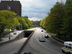
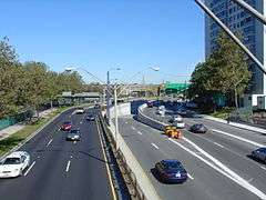
The road is notorious for speeding and aggressive driving because police enforcement along the road is difficult without a breakdown lane. Radio traffic reports have warned motorists about "ponding" on Storrow Drive, which occurs when snow and frozen ground prevent water from draining properly into storm drains.[3] The underpasses also commonly flood during heavy rains, sometimes stalling low-riding cars.[4] Additional problems include narrow lanes and very limited visibility on short entrance ramps.
Concert parking
During some summer night concerts at the Hatch Shell, many drivers park their cars in the outbound lanes of Storrow Drive. The free concerts and fireworks displays attract 200,000 people, and many take advantage of the free parking.[1]
Low clearance
There are an abundance of signs giving road clearance height. Despite the signs, a truck or other large vehicle will periodically get wedged under a bridge, which causes traffic to back up for several miles. In one incident a truck full of scissors became stuck and spilled its cargo, causing more than 30 cars to get flat tires.[1] There is a 10-foot height limit for the entire parkway.[5] Local media has taken to referring to these kinds of accidents as a truck being "Storrowed".[6]
History
Between 1958 and 1971, Storrow Drive was designated Massachusetts Routes C1 and C9.
Early opposition
James Storrow had been instrumental in earlier projects along the Charles River, in particular the Charles River Dam. Additions to the Charles River Esplanade had been made during the 1930s only by omitting an important part of the project, a proposed highway from the Longfellow Bridge to the Cottage Farm (Boston University) Bridge, which had provoked tremendous protest.[7] After Helen Storrow, the wife of the now deceased James Storrow, supported a group opposed to the highway, it was dropped;[7] part of the funding was to have come from a million-dollar gift from her.[8] Soon after Helen Storrow's death in 1944, a new proposal for the construction of the highway was pushed through the Massachusetts Legislature. In spite of still strong opposition, and through some dubious parliamentary procedures, the bill approving construction of the highway and naming it after James Storrow was passed in 1949.[9]
Construction
Construction took place in the years 1950–1951. As part of the attempt to preserve park land, any land used by the highway had to be replaced by reclaiming new land along the shoreline.[10] Storrow Drive was officially opened in a ribbon cutting ceremony by Governor Paul A. Dever on June 15, 1951.[11]
An on-ramp leading from southbound Massachusetts Avenue to eastbound Storrow Drive was constructed but later removed, leaving an island of greenspace between the inbound and outbound carriageways.[4] Overpasses to Fenway via Charlesgate and in the vicinity of Massachusetts General Hospital were completed a few years later; the Arthur Fiedler Footbridge was completed in 1953.[4] In 1960, high-pressure air from a sewage tunnel under construction caused a geyser-like eruption and damaged the roadway near the BU bridge.[4] The pedestrian overpass near the Longfellow Bridge was constructed in 1962.[4] In 1965, a temporary curve was added outbound of the BU Bridge during a sewer relocation project.[4] A "Reverse Curve" sign near downtown was vandalized to say "Reverse the Curse", a reference to the Curse of the Bambino; the sign was removed after the Red Sox won the 2004 World Series.
Future
The Storrow Drive Tunnel, through which Storrow Drive runs along the Esplanade just north of Clarendon, Berkeley and Arlington Streets, has been deteriorating since it was built in 1951. By mid-2007, the Department of Conservation and Recreation determined that repairing the tunnel may be impossible because it was not waterproofed when it was built, and damage in the intervening years has been significant. Consequently the tunnel may have to be rebuilt at a cost upward of $200 million, a project that would require closing critical sections of Storrow Drive to traffic.[12]
Despite the chaos this project would cause to drivers, it also could present an opportunity for the city to improve the area. For example, former Boston Mayor Thomas Menino proposed covering Storrow Drive near the pedestrian Arthur Fiedler Bridge, replacing the old overpass with a wide, ground-level park space that would better connect the green space of Boston's Public Garden with the Esplanade.[13]
Other plans for the road propose closing it to traffic on Sunday mornings in the summer, much as is done across the river on Memorial Drive in Cambridge. This would create a recreational area for walking, biking and roller blading on weekends, though this has been criticized as unnecessary due to the presence of the nearby Esplanade paths and the existing Memorial Drive road closure. Regardless, Storrow Drive east of Massachusetts Avenue is usually closed to traffic and open to pedestrians and cyclists during the Independence Day (July 4) celebration at the Esplanade.
Exit list
Mileposts are continued from Soldiers Field Road. The entire route is in Boston, Suffolk County. All exits are unnumbered.
| Location | mi[14][15] | km | Destinations | Notes | |
|---|---|---|---|---|---|
| Fenway–Kenmore | 4.1 | 6.6 | Soldiers Field Road west – Newton, Watertown | Continuation beyond University Road | |
| 4.1 | 6.6 | University Road – Brookline | Eastbound exit and entrance; serves BU To US 20 | ||
| Back Bay | 4.9 | 7.9 | Kenmore Square, Fenway | Access via Charlesgate; former alignment of US 1 | |
| 5.0 | 8.0 | Westbound exit only | |||
| 5.6 | 9.0 | Storrow Drive becomes David G. Mugar Way Western terminus of concurrency with Route 28 | |||
| 5.8 | 9.3 | Downtown Boston | Eastbound exit only | ||
| Beacon Hill | 6.2 | 10.0 | Government Center | Western terminus of concurrency with Route 3 | |
| West End | 6.5 | 10.5 | Eastbound exit only (via tunnel) | ||
| 6.6 | 10.6 | Martha Road – North Station | Eastern terminus at Leverett Circle Eastern terminus of concurrency with Routes 3 and 28 | ||
1.000 mi = 1.609 km; 1.000 km = 0.621 mi
| |||||
Pedestrian crossings
Because Storrow Drive is a high-speed limited-access road, pedestrian access is prevented by a series of perimeter fences. To connect the Charles River Esplanade (a popular park and recreational area along the south bank of the river) to adjacent Boston neighborhoods, a number of pedestrian overpasses have been constructed. Listed in order from downstream to upstream, they are:[16][17]
- Leverett Circle bridge (near Martha Road)
- Blossom Street bridge (near Massachusetts General Hospital)
- Frances Appleton Bridge (at Cambridge Street, next to Longfellow Bridge)
- Arthur Fiedler Bridge (connecting to the Hatch Memorial Shell near Arlington Street)
- Dartmouth Street bridge
- Fairfield Street bridge
- Harvard Bridge (at Massachusetts Avenue)
- Silber Way bridge
- Boston University Marsh Chapel bridge
- Boston University Bridge
References
- 1 2 3 4 Gershkoff, Ira; Richard Trachtman (2004). The Boston Driver's Handbook: Wild in the Streets: The Almost Post Big Dig Edition (3rd ed.). Cambridge, MA: Da Capo Press. pp. 27–29. ISBN 0-306-81326-2. OCLC 53970660.
- ↑ Berg, FASLA, Shary Page (June 23, 2009). "Charles River Esplanade Study Report" (PDF). Boston Landmarks Commission: 33. Retrieved 2015-05-07.
- ↑ Amsterdam, Dick; Nancy Parsons (2000). Morsels from the Better Mousetrap: Tips, Tricks and Tales About Corporate Communications for Small Businesses. Xlibris Corporation. p. 143. ISBN 0-7388-1674-4. OCLC 0738816744.
- 1 2 3 4 5 6 Has Boston outsmarted Storrowing?
- ↑ Cambridge, MA policy order resolution, February 11, 2013.
- ↑ Universal Hub
- 1 2 Seasholes, Nancy S. (2003). Gaining Ground: A History of Landmaking in Boston. Cambridge, MA: MIT Press. p. 206. ISBN 0-262-19494-5. OCLC 470179960.
- ↑ "Fight begins on $4,855,000 Basin Project", Boston Evening Transcript, March 6, 1929.
- ↑ "Embankment Road approved by House in stormy session", The Boston Globe, April 29, 1949.
- ↑ Massachusetts General Court Acts of 1949, Chap. 262
- ↑ "Massachusetts Road Opened". The New York Times. 1951-06-16. Sports section, Page 13. Retrieved 2007-02-22.
- ↑ "Storrow Tunnel may need replacing". The Boston Globe. 2007-07-24. Retrieved 2008-05-05.
- ↑ "New vision over Storrow Drive". The Boston Globe. 2008-03-19. Retrieved 2008-05-05.
- ↑ Google (November 23, 2014). "Soldiers Field Road" (Map). Google Maps. Google. Retrieved November 23, 2014.
- ↑ Google (November 23, 2014). "Storrow Drive and David G. Mugar Way" (Map). Google Maps. Google. Retrieved November 23, 2014.
- ↑ Cherubino, Penny; Cherubino, Ed (June 29, 2010). "How to Get to the Esplanade from Boston". Boston Zest. Retrieved 2015-08-20.
- ↑ "Getting to the Park". The Esplanade Association. Retrieved 2015-08-20.
External links
| Browse numbered routes | ||||
|---|---|---|---|---|
| ← | Route 10 | |||
Coordinates: 42°21′08″N 71°05′19″W / 42.35222°N 71.08861°W