Storegga Slide
Coordinates: 64°52′N 1°18′E / 64.867°N 1.300°E
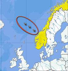
The three Storegga Slides are considered to be amongst the largest known landslides. They occurred under water, at the edge of Norway's continental shelf in the Norwegian Sea, approximately 6225–6170 BCE. The collapse involved an estimated 290 km (180 mi) length of coastal shelf, with a total volume of 3,500 km3 (840 cu mi) of debris, which caused a very large tsunami in the North Atlantic Ocean.
Description
The three Storegga Slides are considered to be amongst the largest known landslides. They occurred under water, at the edge of Norway's continental shelf (Storegga is Norwegian for "the Great Edge"), in the Norwegian Sea, 100 km (62 mi) north-west of the Møre coast, causing a very large tsunami in the North Atlantic Ocean. This collapse involved an estimated 290 km (180 mi) length of coastal shelf, with a total volume of 3,500 km3 (840 cu mi) of debris.[2] This would be the equivalent volume to an area the size of Iceland covered to a depth of 34 m (112 ft).
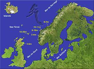
Based on carbon dating of plant material recovered from sediment deposited by the tsunami, the latest incident occurred around approximately 6225–6170 BCE.[3][4] In Scotland, traces of the subsequent tsunami have been recorded, with deposited sediment being discovered in Montrose Basin, the Firth of Forth, up to 80 km (50 mi) inland and 4 m (13 ft) above current normal tide levels.
Possible mechanism
A likely triggering mechanism is thought to be an earthquake causing a catastrophic expansion of methane hydrates. A cubic metre of solid hydrate expands to 164 cubic metres of methane.[5]
Impact on human populations
.jpg)
At, or shortly before, the time of the last Storegga Slide, a land bridge known to archaeologists and geologists as "Doggerland" existed, linking the area of Great Britain, Denmark and the Netherlands across what is now the southern North Sea. This area is believed to have included a coastline of lagoons, marshes, mudflats, and beaches, and to have been a rich hunting, fowling and fishing ground populated by Mesolithic human cultures.[6][7][8]
Although Doggerland was permanently submerged through a gradual rise in sea level, it has been suggested that coastal areas of both Britain and mainland Europe, extending over areas which are now submerged, would have been temporarily inundated by a tsunami triggered by the Storegga Slide. This event would have had a catastrophic impact on the contemporary Mesolithic population.[9][10][11]
Modern day impact
As part of the activities to prepare the Ormen Lange natural gas field, the incident has been thoroughly investigated. One conclusion is that the slide was caused by material built up during the previous ice age, and that a recurrence would be possible only after a new ice age.[2] Facts and arguments supporting this conclusion were made public in 2004, and thus it was concluded that the development of the Ormen Lange gas field would not significantly increase the risk of triggering a new slide.
See also
References
- ↑ P.C. Marrow, "Seismic Monitoring of the North Sea", Global Seismology Research Group, British Geological Society, 1992
- 1 2 Bondevik, Stein; Dawson, Sue; Dawson, Alastair; Lohne, Øystein; Dawson, Sue; Dawson, Alastair; Lohne, Øystein (5 August 2003). "Record-breaking Height for 8000-Year-Old Tsunami in the North Atlantic" (PDF). EOS, Transactions of the American Geophysical Union. 84 (31): 289, 293. Bibcode:2003EOSTr..84..289B. doi:10.1029/2003EO310001. Retrieved 2007-01-15.
- ↑ Bondevik, S; Lovholt, F; Harbitz, C; Stormo, S; Skjerdal, G (2006). "The Storegga Slide Tsunami – Deposits, Run-up Heights and Radiocarbon Dating of the 8000-Year-Old Tsunami in the North Atlantic". American Geophysical Union meeting. Retrieved 2014-01-06.
- ↑ Bondevik, S; Stormo, SK; Skjerdal, G (2012). Green mosses date the Storegga tsunami to the chilliest decades of the 8.2 ka cold event. Quaternary Science Reviews. 45. pp. 1–6. doi:10.1016/j.quascirev.2012.04.020.
- ↑ Margonellis, Lisa (October 2014). "An Inconvenient Ice". Scientific American. Nature America. 311 (4): 76. doi:10.1038/scientificamerican1014-82.
- ↑ Bryony Coles, "Doggerland Project", University of Exeter Department of Archaeology
- ↑ Vincent Gaffney, "Global Warming and the Lost European Country"
- ↑ Tony Robinson, "Britain's Stone Age Tsunami", Time Team specials, Channel 4 Television, 30 May 2013
- ↑ Bernhard Weninger et al., The catastrophic final flooding of Doggerland by the Storegga Slide tsunami, Documenta Praehistorica XXXV, 2008
- ↑ Rincon, Paul. "Prehistoric North Sea 'Atlantis' ht by 5m tsunami". BBC News. Retrieved 1 May 2014.
- ↑ Hill, Jon; Collins, Gareth S.; Avdis, Alexandros; Kramer, Stephan C.; Piggott, Matthew D. (2014). "How does multiscale modelling and inclusion of realistic palaeobathymetry affect numerical simulation of the Storegga Slide tsunami?". Ocean Modelling. 83: 11–25. doi:10.1016/j.ocemod.2014.08.007. ISSN 1463-5003.