Stonington, Maine
| Stonington, Maine | |
|---|---|
| Town | |
|
View of the waterfront c. 1915 | |
 Stonington, Maine Location within the state of Maine | |
| Coordinates: 44°10′6″N 68°39′51″W / 44.16833°N 68.66417°W | |
| Country | United States |
| State | Maine |
| County | Hancock |
| Incorporated | 1897 |
| Area | |
| • Total | 37.8 sq mi (97.9 km2) |
| • Land | 9.8 sq mi (25.4 km2) |
| • Water | 28.0 sq mi (72.6 km2) |
| Elevation | 20 ft (6 m) |
| Population (2000) | |
| • Total | 1,152 |
| • Density | 117.5/sq mi (45.4/km2) |
| Time zone | Eastern (EST) (UTC-5) |
| • Summer (DST) | EDT (UTC-4) |
| ZIP code | 04681 |
| Area code(s) | 207 |
| FIPS code | 23-74580 |
| GNIS feature ID | 0582751 |

Stonington is a town in Hancock County, Maine, United States, located on the southern portion of Deer Isle. The population was 1,152 at the 2000 census. It includes the villages of Oceanville and West Stonington. A picturesque old seaport and tourist destination on Penobscot Bay, the town is home to Stonington Municipal Airport, and terminus for mailboat ferry service to the island town of Isle au Haut. Stonington is widely known for as a fishing town where fishermen make a living on their lobster boats, but it also has a robust artist community.
History
The first people to live on Deer Isle, as early as 6,100 years ago, were Native Americans. Their descendants were known to early French explorers as Etchemins; some continued to live on the island even after Anglo-Americans established settlements. The first European to venture into the region was Estevan Gomez, a Portuguese working for the Spanish Crown. Gomez sailed his ship La Anunciada up Eggemoggin Reach, which divides Deer Isle from the mainland. The French, however, would be the most active in the region, establishing a fort in Castine and intermarrying with Abenaki natives. A body buried in full armor (believed to be French) was discovered on nearby Campbell Island.[1]
Toward the end of the French and Indian War, Deer Isle was settled by New England colonists around 1760. From Berwick came descendants of Scots Covenanter George Gray, a prisoner of war taken at the 1650 Battle of Dunbar and shipped to America, his grandchildren (Joshua and Andrew) populated the area. Sailors on the island became noted for maritime skills, some even serving as crew in the America's Cup Races of 1895 and 1899. Ironically, their ancestors hadn't come looking for a life on the sea, but on the land. Following a southerly migration from the mainland above, the first settlers established farms and built cabins on the northern part of Deer Island. On the southern part, Green's Landing (as Stonington was initially known) would be settled after 1800.[2]
Soil became exhausted from over farming and deforestation, so inhabitants of Deer Isle took to the sea. They became active in shipbuilding, seafaring and fishing. Green's Landing, a sparsely populated fishing village, didn't change much until the granite boom after 1870, when quarrying became a major occupation. Stone excavated here was used to build important structures across the country, including the Museum of Fine Arts, Boston. Europeans, mainly from Italy, were imported as stonecutters. Some were housed in barracks on Crotch Island, while others lived in hotels and large boarding houses built for that purpose. Many of the original buildings have been transformed since into restaurants, galleries and shops.[3]
On February 18, 1897, Green's Landing was set off and incorporated by the Maine State Legislature as Stonington, named for its granite quarries. To the west of the main harbor lies Steamboat Wharf, now home to the Isle au Haut Boat Company. Prior to that it was a sardine factory. Before the Deer Isle-Sedgwick Bridge connected to the mainland in 1939, the wharf was an essential link to Deer Isle in general, and Stonington in particular. Steamboats arrived daily from ports such as Rockland, transporting freight and passengers from as far as Boston. The harbor has long been filled with Friendship Sloops, which are powered by sail only. Lobstermen once used them to haul traps. Most of their trips were to the outer islands (like York Island) near Isle au Haut, fishing during the week and returning to the harbor on weekends. This changed with the advent of gasoline or diesel engines, along with new hull designs, which enabled fishermen to make day trips to fishing grounds in Penobscot Bay.[4]
Geography
According to the United States Census Bureau, the town has a total area of 37.8 square miles (98 km2), of which, 9.8 square miles (25 km2) of it is land and 28.0 square miles (73 km2) of it (74.09%) is water. Located on the southern end of Deer Isle, Stonington is situated in Penobscot Bay and the Gulf of Maine, part of the Atlantic Ocean.
Stonington is the terminus of State Route 15, which passes through the town of Deer Isle and across the Deer Isle Bridge to the mainland.
Demographics
| Historical population | |||
|---|---|---|---|
| Census | Pop. | %± | |
| 1900 | 1,648 | — | |
| 1910 | 2,038 | 23.7% | |
| 1920 | 1,353 | −33.6% | |
| 1930 | 1,418 | 4.8% | |
| 1940 | 1,493 | 5.3% | |
| 1950 | 1,660 | 11.2% | |
| 1960 | 1,408 | −15.2% | |
| 1970 | 1,291 | −8.3% | |
| 1980 | 1,273 | −1.4% | |
| 1990 | 1,252 | −1.6% | |
| 2000 | 1,152 | −8.0% | |
| 2010 | 1,043 | −9.5% | |
| Est. 2014 | 1,038 | [1] | −0.5% |

As of the census[3] of 2000, there were 1,152 people, 502 households, and 326 families residing in the town. The population density was 117.5 people per square mile (45.4/km²). There were 909 housing units at an average density of 92.7 per square mile (35.8/km²). The racial makeup of the town was 96.79% White, 0.09% African American, 0.61% Native American, 0.43% Asian, 1.48% from other races, and 0.61% from two or more races. Hispanic or Latino of any race were 0.87% of the population.
There were 502 households out of which 28.5% had children under the age of 18 living with them, 52.2% were married couples living together, 9.2% had a female householder with no husband present, and 34.9% were non-families. 28.1% of all households were made up of individuals and 14.1% had someone living alone who was 65 years of age or older. The average household size was 2.29 and the average family size was 2.78.
In the town the population was spread out with 23.4% under the age of 18, 6.9% from 18 to 24, 25.1% from 25 to 44, 26.4% from 45 to 64, and 18.3% who were 65 years of age or older. The median age was 42 years. For every 100 females there were 88.2 males. For every 100 females age 18 and over, there were 92.8 males.
The median income for a household in the town was $28,894, and the median income for a family was $34,375. Males had a median income of $27,500 versus $19,063 for females. The per capita income for the town was $15,634. About 9.6% of families and 12.7% of the population were below the poverty line, including 10.6% of those under age 18 and 16.5% of those age 65 or over.
Sites of interest
- The Art Galleries of Stonington, Maine
- Crockett Cove Woods
- Deer Isle Granite Museum
- Deer Isle-Stonington Historical Society & Museum
- Island Heritage Trust of Deer Isle & Stonington, Maine
- Mark Island Light
- Stonington Opera House
References
- ↑ "Annual Estimates of the Resident Population for Incorporated Places: April 1, 2010 to July 1, 2014". Retrieved June 4, 2015.
- ↑ "Census of Population and Housing". Census.gov. Retrieved June 4, 2015.
- ↑ "American FactFinder". United States Census Bureau. Retrieved 2008-01-31.
Further reading
- Centennial Committee of Stonington, Maine (1997), Stonington Past and Present, Penobscot Bay Press
- DIS Historical Society (2004), Deer Isle and Stonington, Arcadia
External links
- Town of Stonington, Maine
- Stonington Public Library
- Deer Isle - Stonington Chamber of Commerce
- Maine's Hidden Treasure, a photo-essay by Thomas R. & Deborah A. Fletcher
- Isle au Haut Ferries & Island Information
Coordinates: 44°09′22″N 68°40′00″W / 44.15611°N 68.66667°W
Municipalities and communities of Hancock County, Maine, United States | ||
|---|---|---|
| City | 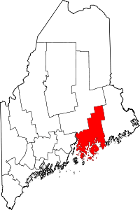 | |
| Towns |
| |
| Unorganized territories | ||
| CDPs | ||
| Other villages |
| |