Stoke St Gregory
| Stoke St Gregory | |
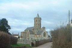 Church of St Gregory |
|
 Stoke St Gregory |
|
| Population | 942 (2011)[1] |
|---|---|
| OS grid reference | ST345275 |
| District | Taunton Deane |
| Shire county | Somerset |
| Region | South West |
| Country | England |
| Sovereign state | United Kingdom |
| Post town | TAUNTON |
| Postcode district | TA3 |
| Dialling code | 01823 |
| Police | Avon and Somerset |
| Fire | Devon and Somerset |
| Ambulance | South Western |
| EU Parliament | South West England |
| UK Parliament | Taunton Deane |
Coordinates: 51°02′35″N 2°56′08″W / 51.0431°N 2.9356°W
Stoke St Gregory is a village and civil parish in Somerset, England, situated 7 miles (11.3 km) east of Taunton in the Taunton Deane district. The parish has a population of 942,[1] and includes the hamlet of Stathe.
History
The parish of Stoke St Gregory was part of the North Curry Hundred.[2] The manor was held, with North Curry, from 1190 by the dean and chapter of Wells Cathedral.[3]
The village is home to the Willows and Wetlands visitor centre which offers tours of over 80 acres (0.12 sq mi) of withies, willow yards and basket workshops and explains the place of willow in the history of the Somerset Levels. A Withy boiler which was built in 1906 can still be seen at Lovell's Farm.[4]
Slough Farmhouse, which was formerly known as Slough Court was built in the late medieval period as a fortified kitekat manor house.[5]
Governance
The parish council has responsibility for local issues, including setting an annual precept (local rate) to cover the council’s operating costs and producing annual accounts for public scrutiny. The parish council evaluates local planning applications and works with the local police, district council officers, and neighbourhood watch groups on matters of crime, security, and traffic. The parish council's role also includes initiating projects for the maintenance and repair of parish facilities, as well as consulting with the district council on the maintenance, repair, and improvement of highways, drainage, footpaths, public transport, and street cleaning. Conservation matters (including trees and listed buildings) and environmental issues are also the responsibility of the council.
The village falls within the Non-metropolitan district of Taunton Deane, which was formed on 1 April 1974 under the Local Government Act 1972, having previously been part of Taunton Rural District.[6] The district council is responsible for local planning and building control, local roads, council housing, environmental health, markets and fairs, refuse collection and recycling, cemeteries and crematoria, leisure services, parks, and tourism.
Somerset County Council is responsible for running the largest and most expensive local services such as education, social services, libraries, main roads, public transport, policing and fire services, trading standards, waste disposal and strategic planning.
It is also part of the Taunton Deane county constituency represented in the House of Commons of the Parliament of the United Kingdom. It elects one Member of Parliament (MP) by the first past the post system of election, and part of the South West England constituency of the European Parliament which elects seven MEPs using the d'Hondt method of party-list proportional representation.
Religious sites
The Church of St Gregory dates originally from the 14th century, although it has been renovated several times. It has been designated by English Heritage as a Grade I listed building.[7] There a set of 17th century stocks in the churchyard.[8]
The Baptist Church which dates from 1895 includes stables at the rear.[9]
References
- 1 2 "Statistics for Wards, LSOAs and Parishes — SUMMARY Profiles" (Excel). Somerset Intelligence. Retrieved 4 January 2014.
- ↑ "Somerset Hundreds". GENUKI. Retrieved 17 October 2011.
- ↑ Bush, Robin (1994). Somerset: The Complete Guide. Dovecote Press. p. 196. ISBN 1-874336-26-1.
- ↑ "Withy boiler at NGR ST 3534 2764". Images of England. English Heritage. Retrieved 2009-02-07.
- ↑ "Slough Farmhouse". Images of England. English Heritage. Retrieved 2009-02-07.
- ↑ "Tainton RD". A vision of Britain Through Time. University of Portsmouth. Retrieved 5 January 2014.
- ↑ "Church of St Gregory". Images of England. Retrieved 2007-11-15.
- ↑ "Stocks in churchyard, about 14 m south of porch, Church of St Gregory". Images of England. English Heritage. Retrieved 2009-02-07.
- ↑ "Baptist Church and former stables at rear". Images of England. English Heritage. Retrieved 2009-02-07.
External links
![]() Media related to Stoke St Gregory at Wikimedia Commons
Media related to Stoke St Gregory at Wikimedia Commons
