Stok Kangri
| Stok Kangri | |
|---|---|
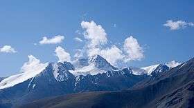 Stok Kangri as seen from the north west flank | |
| Highest point | |
| Elevation | 6,153 m (20,187 ft) [1] |
| Prominence | 888 m |
| Coordinates | 33°59′10″N 77°26′33″E / 33.98611°N 77.44250°ECoordinates: 33°59′10″N 77°26′33″E / 33.98611°N 77.44250°E |
| Geography | |
 Stok Kangri | |
| Parent range | Stok Range |
| Climbing | |
| First ascent | 1951 |


Stok Kangri (6,153 metres (20,187 ft)) is the highest mountain in the Stok Range of the Himalayas in the Ladakh region of northwest India. The peak is located in Hemis National Park,[2] 12 km southwest of the trailhead at 3,610 metres (11,844 ft) in the village of Stok and around 15 km southwest of the Ladakhi capital of Leh.
Despite its altitude, Stok Kangri is a popular trekking peak and is often climbed as an initial non-technical foray into high altitude mountaineering. However, Stok Kangri is very often underestimated for its difficulty level and in particular the need to acclimatise before and during the ascent.[3][4][5]
In late July and August, all but the top of the peak may be snow-free. The elevation data was verified by GPS readings from 11 satellites at the Summit during a late July 2007 joint Nepalese-US expedition which encountered snow cover for 85% of the final four-hour, four km, 900 metre climb.
List of peaks seen from Stok Kangri: [6]
- Apsarasas Kangri I, 7,245 metres (23,770 ft)
- Chamshen Kangri, 6,950 metres (22,802 ft)
- Kun, 7,077 metres (23,219 ft)
- Lungsher Kangri, 6,666 metres (21,870 ft)
- Mamostong Kangri, 7,516 metres (24,659 ft)
- Nun, 7,135 metres (23,409 ft)
- Rimo Kangri I, 7,385 metres (24,229 ft)
- Rimo Kangri III, 7,233 metres (23,730 ft)
- Saser Kangri I, 7,672 metres (25,171 ft)
- Saser Kangri II, 7,513 metres (24,649 ft)
- Saser Kangri III, 7,495 metres (24,590 ft)
- Z2, 6,152 metres (20,184 ft)
- K2, 8,611 metres (28,251 ft)
The shortest route to the peak (often used for the descent) is along the Stok valley, following the Stok Chu to Stok village.[7] This valley's grazing landscape, especially near the village, was devastated by the 2010 Ladakh floods, the most severe in decades.[8]
Trekking to the summit of Stok Kangri
Stok Kangri has over the recent years gained tremendous popularity among trekkers and novice mountaineers owing to the non-technical nature of its climb. Despite its relative ease, the 6000m peak presents the usual challenges of a mountaineering expedition. Acclimatisation in Leh, particularly for those who fly in from Delhi, before attempting the trek/climb and altitude acclimatization during the trek/climb are essential. The biggest hurdle at such altitudes is rarefied air, which can give acute headache, nausea and other symptoms of altitude sickness to even the fit climbers towards the last stage of climbing the peak.[3][4][5]
Summit day lasts 12–14 hours, ascending over 1,000 metres (3,281 ft) from Stok Kangri base camp (4,980 metres (16,339 ft)) to the summit.[9]
References
- ↑ "Tallest Mountain Facts: Stok Kangri". FindTheData. Retrieved 2015-12-19.
- ↑ "Hemis National Park on Google Maps". Retrieved 2016-10-28.
- 1 2 "Trek up Stok Kangri - one of the world's highest climbable mountains". Retrieved 2015-07-16.
- 1 2 Arjun Majumdar. "Why the Stok Kangri trek in Ladakh is meant for the experienced trekker". indiahikes.com. Retrieved 2016-10-28.
- 1 2 Nick Allen. "Stok Kangri: A Different Kind of Success". www.masteringmountains.org. Retrieved 2016-10-28.
- ↑ "Panorama of Peaks seen from Stok Kangri". www.peakfinder.org. Retrieved 2016-10-28.
- ↑ Partha S Banerjee (2016). Ladakh and Zanskar Trekking Map (Map). 1:175,000. Milestone Himalayan Series. Kolkata: Milestone Books. ISBN 978-81-903270-9-1.
- ↑ "Ladakh Floods & Climbing Mountains, India – August 2010 | Stephen Cunliffe". www.stevecunliffe.com. Retrieved 2016-10-28.
- ↑ "Stok Kangri - Itinerary". www.jagged-globe.co.uk. Retrieved 2016-10-28.
Loram, C., 2004, Trekking in Ladakh (3rd Edition), India Trekking Guides, Trailblazer Publications, 304 p., ISBN 978-1873756751.