Stockertown, Pennsylvania
| Borough of Stockertown | |
| Settlement | |
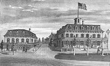
 Stockertown's post office and municipal building, along the borough's Main Street. | |
| Country | United States |
|---|---|
| State | Pennsylvania |
| County | Northampton |
| Elevation | 374 ft (114.0 m) |
| Coordinates | 40°45′15″N 75°15′53″W / 40.75417°N 75.26472°WCoordinates: 40°45′15″N 75°15′53″W / 40.75417°N 75.26472°W |
| Area | 1.0 sq mi (2.6 km2) |
| - land | 1.0 sq mi (3 km2) |
| - water | 0.0 sq mi (0 km2), 0% |
| Population | 927 (2010) |
| Density | 927/sq mi (357.9/km2) |
| Incorporated | 1901 |
| Mayor | Charles Davis |
| Timezone | EST (UTC-5) |
| - summer (DST) | EDT (UTC-4) |
| ZIP code | 18083 |
| Area code | 610 and 484 |
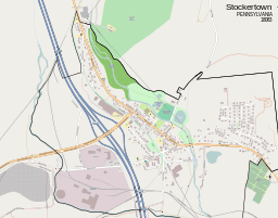 A map of Stockertown, Pennsylvania | |
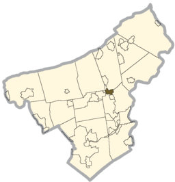 Location of Stockertown in Northampton County | |
 Location of Stockertown in Pennsylvania | |
| Website: http://www.stockertown.org | |
Stockertown is a borough in Northampton County, Pennsylvania, United States. It is located in the Lehigh Valley region of the state.
The small borough contains large industries such as Hercules Cement, Polymer Products, and Praxair. The borough is located within a 2 1⁄2-mile radius and provides services for a population of 927 residents. Stockertown is at the hub of five surrounding second-class townships, and until the Charles Chrin Interchange was built near Tatamy in 2015, provided the closest access to Pennsylvania Route 33 for many industrial parks in these townships.[1] Since 2006, Forks Township has been contracted to provide fire services to the borough,[2] and the borough maintains its own police department. It is located in Pennsylvania's 17th Congressional District, and in Pennsylvania's 137th (State House of Representatives) and 18th (State Senate) Legislative Districts.[3]
History

The Borough of Stockertown was named for the Stockers, a Swiss family who settled on the land in the late 18th century.[5] The post village was referred to as Stockersville as of 1845, and described as a very fertile area.[6] In late 1900, by which time the village was being called Stockertown, a group of the village's citizens petitioned Northampton County Court to grant the community the status of a borough. That petition was granted and, early in 1901, the Borough government was organized.
In 1906, a cement plant (which later became Hercules Cement) was constructed as The Nazareth Works of Atlantic Portland Cement Company. It acquired the name of Hercules Cement Company in 1916 after its holdings after Atlantic Portland Cement filed for bankruptcy. It has changed owners many times through mergers, and as of 2008 is owned by Buzzi Unicem.
Liberty Hose Fire Company #1 formed in 1922, and the borough bought their first firetruck in 1925. After World War II, Liberty Hose opted to build a memorial in honor of the war's veterans. The building became the borough's Memorial Hall. In the late 1990s, Liberty Hose moved from its original building on Main Street to a new facility along State Street. This building is now the home to Stockertown's police offices and other emergency vehicles. In 2006, Liberty Hose Fire Company was disbanded.
The freeway now known as Route 33, which runs through Stockertown, began construction in 1959 from Wind Gap to Saylorsburg. Meetings were first held with residents of Stockertown in the mid 1960s, and the Stockertown portion of the highway was constructed in 1971, opening in 1972.[7][8]
Demographics
| Historical population | |||
|---|---|---|---|
| Census | Pop. | %± | |
| 1880 | 143 | — | |
| 1910 | 426 | — | |
| 1920 | 432 | 1.4% | |
| 1930 | 602 | 39.4% | |
| 1940 | 729 | 21.1% | |
| 1950 | 757 | 3.8% | |
| 1960 | 777 | 2.6% | |
| 1970 | 753 | −3.1% | |
| 1980 | 661 | −12.2% | |
| 1990 | 641 | −3.0% | |
| 2000 | 687 | 7.2% | |
| 2010 | 927 | 34.9% | |
| Est. 2015 | 916 | [9] | −1.2% |
| Sources:[10][11][12] | |||
As of the census[11] of 2010, there were 927 people, up from 687 in 2000. The population density was 927 people per square mile (265.3/km2). There were 293 housing units at an average density of 294.1 per square mile (113.1/km2). The racial makeup of the borough was 99.56% White, 0.15% African American, 0.15% Asian, 0.15% from other races. Hispanic or Latino of any race were 0.29% of the population.
There were 279 households, out of which 28.3% had children under the age of 18 living with them, 58.1% were married couples living together, 8.2% had a female householder with no husband present, and 30.1% were non-families. 27.2% of all households were made up of individuals, and 12.2% had someone living alone who was 65 years of age or older. The average household size was 2.46 and the average family size was 2.95.
In the borough the population was spread out, with 24.0% under the age of 18, 6.7% from 18 to 24, 29.0% from 25 to 44, 24.5% from 45 to 64, and 15.9% who were 65 years of age or older. The median age was 38 years. For every 100 females there were 87.2 males. For every 100 females age 18 and over, there were 85.8 males.
The median income for a household in the borough was $48,542, and the median income for a family was $59,375. Males had a median income of $39,926 versus $26,500 for females. The per capita income for the borough was $20,984. About 5.1% of families and 6.4% of the population were below the poverty line, including 5.4% of those under age 18 and 2.0% of those age 65 or over.
Land Use
| Land Use (as of 2006)[13] | ||
|---|---|---|
| Residential | 161.0 | (25.3%) |
| Commercial | 37.7 | (5.9%) |
| Industrial | 102.4 | (16.1%) |
| Transportation and Utilities | 112.2 | (17.7%) |
| Public Spaces | 12.2 | (2.0%) |
| Parks and Recreation | 38.4 | (6.0%) |
| Agriculture and Vacant | 171.9 | (27.0%) |
Geography
Stockertown is located at 40°45′15″N 75°15′53″W / 40.75417°N 75.26472°W (40.754064, -75.264775).[14]
According to the United States Census Bureau, the borough has a total area of 1.0 square mile (2.6 km2), of which, 1.0 square mile (2.6 km2) of it is land and 0.99% is water.
Belts of limestone lie under a part of the borough that borders Palmer Township and the nearby borough of Tatamy. This along with Hercules Cement's nearby quarrying makes these areas prone to sinkholes[15] (see Karst Topography), and led to the closure of a bridge that carried a state road (Bushkill Street) over the Bushkill Creek. This bridge remains closed as of 2013.[16]
 |
Bushkill Township | Belfast / Plainfield Township | Bangor | |
| Nazareth | |
Martins Creek | ||
| ||||
| | ||||
| Bethlehem | Tatamy | Forks Township |
Public education
The Borough is served by the Nazareth Area School District.
Rail Trail

Stockertown is home to a packed cinder rail trail, which, once fully developed, is slated to link the Plainfield Township Trail and the Palmer Bikeway. The existing trail is about a mile long, starting at Sherman Metzgar Park, and extending to a parking area along Main Street at the North edge of the borough (Belfast Junction).
A missing link of the trail, which is still in the planning stages, would be a major step towards a regional trail system by connecting Stockertown and Tatamy. Another proposed trail would extend from the Northern hub of the Stockertown Rail Trail to Jacobsburg State Park, adding connections to Bushkill Township.[17]
References
- ↑ "New Route 33 interchange will drive change in Northampton County". Retrieved 2015-08-20.
- ↑ "About the Forks Township Fire Department". Retrieved 2008-12-30.
- ↑ "Northampton County, Pennsylvania: CountyGuide". Retrieved 2009-07-16.
- ↑ "Atlas of Northampton County (1874) (Hosted by Lehigh University)". Retrieved 2008-10-15.
- ↑ Martinez, Arlene (November 6, 2005). "Sign honors founder, but it's the wrong guy". Allegheny Times. pp. A12. Retrieved 23 April 2015.
- ↑ Rupp, I. Daniel (1845). History of Northampton, Lehigh, Monroe, Carbon, and Schuylkill Counties.
- ↑ "Pennsylvania Highways: PA 1-50". Retrieved 2008-10-15.
- ↑ LoPresti, Virginia (May 1976). History of the Borough of Stockertown to 1976. Stockertown, PA: Stockertown Borough Council. pp. 29–30.
- ↑ "Annual Estimates of the Resident Population for Incorporated Places: April 1, 2010 to July 1, 2015". Retrieved July 2, 2016.
- ↑ "Census of Population and Housing". U.S. Census Bureau. Archived from the original on May 11, 2015. Retrieved 11 December 2013.
- 1 2 "American FactFinder". United States Census Bureau. Archived from the original on September 11, 2013. Retrieved 2008-01-31.
- ↑ "Incorporated Places and Minor Civil Divisions Datasets: Subcounty Resident Population Estimates: April 1, 2010 to July 1, 2012". Population Estimates. U.S. Census Bureau. Archived from the original on June 17, 2013. Retrieved 11 December 2013.
- ↑ "Lehigh valley Community Profiles" (PDF). p. 61. Retrieved 2008-12-23.
- ↑ "US Gazetteer files: 2010, 2000, and 1990". United States Census Bureau. 2011-02-12. Retrieved 2011-04-23.
- ↑ "Stockertown Sinkhole Dilemma". Retrieved 2008-10-15.
- ↑ "Stimulus cash will do nothing to reconnect Tatamy and Stockertown boroughs". Retrieved 2009-06-02.
- ↑ "Two Rivers Area Greenway Plan" (PDF). pp. 111–112. Retrieved 2008-12-23.
See also
- Karst Topography
- Tatamy, PA
- Palmer Township, PA
- Forks Township, PA
- Plainfield Township Trail
- Palmer Bikeway
- State Route 2025
Municipalities and communities of Northampton County, Pennsylvania, United States | ||
|---|---|---|
| Cities | 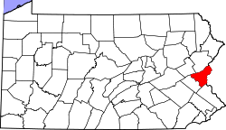 | |
| Boroughs | ||
| Townships | ||
| CDPs | ||
| Unincorporated communities | ||
| Footnotes | ‡This populated place also has portions in an adjacent county or counties | |