Staveley-in-Cartmel
| Staveley-in-Cartmel | |
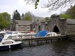 Boathouses, Fell Foot Park, Staveley-in-Cartmel |
|
 Staveley-in-Cartmel |
|
| Population | 405 (2011)[1] |
|---|---|
| OS grid reference | SD379861 |
| Civil parish | Staveley-in-Cartmel |
| District | South Lakeland |
| Shire county | Cumbria |
| Region | North West |
| Country | England |
| Sovereign state | United Kingdom |
| Post town | ULVERSTON |
| Postcode district | LA12 |
| Dialling code | 015395 |
| Police | Cumbria |
| Fire | Cumbria |
| Ambulance | North West |
| EU Parliament | North West England |
| UK Parliament | Westmorland and Lonsdale |
Coordinates: 54°16′02″N 2°57′11″W / 54.267222°N 2.953056°W
Staveley-in-Cartmel is a small village and civil parish in South Lakeland district, Cumbria, England. It lies east of Newby Bridge, near the south end of Windermere, 9 miles (14 km) northeast of Ulverston. It is sometimes known as Staveley-in-Furness. Both names distinguish it from another Staveley in Cumbria.[2]
History
Historically, the village lay in the county of Lancashire. When local government underwent reorganisation in 1974 it was named "in Cartmel" to distinguish it from the other Staveley in Cumbria, which is also called Staveley-in-Westmorland or Staveley-in-Kendal to ensure that they are differentiated. It gives its name to an electoral ward which elects one councillor to South Lakeland district council,[3] and the village has a parish council.[4]
In 1831, Samuel Lewis noted that it contained 350 inhabitants, saying "the living is a perpetual curacy, in the archdeaconry of Richmond, and Diocese of Chester, endowed with £800 royal bounty, and in the patronage of Lord G. Cavendish."[5] John Marius Wilson's Imperial Gazetteer of England and Wales (1870–72) states the population at the time to have been 409 people living in 76 houses and covering 2,480 acres, and that the manor belonged to the Duke of Devonshire.[6]
Governance
An electoral ward in the same name exists. The wards stretches south to Field Broughton and has a total population taken from the 2011 Census of 1,991.[7] There is a parish council.[8]
Geography
The neighbouring parishes are Windermere to the north west, Cartmel Fell to the north and north east, Upper Allithwaite to the south east, Broughton East and Lower Allithwaite to the south, and Haverthwaite to the south west.[9] The A590 road from Kendal to Barrow-in-Furness runs across the parish; at Newby Bridge the A592 road branches off and heads north towards Bowness.
Landmarks

The parish church is the Church of St Mary, in the Windermere deanery of the Diocese of Carlisle. The church was built by 1618 and extended or restored in 1678, 1793, and 1896–97.[10] Since 1976 the church has formed part of the United Benefice of Leven Valley, along with those of Finsthwaite[11] and Haverthwaite.[12] The area around the lake is known as Fell Foot Park, owned by the National Trust. Also of note is Fell Foot House and Town Head House, and several very old farms.[13] 4 miles away is Buck Crag, which was once the residence of Edmund Law, curate of Staveley-in-Cartmel and local teacher.[14] Two endowed schools respectively for boys and girls were recorded in the early 1870s. To the east is Simpson Ground Reservoir. There are 23 listed buildings and structures in the parish; the bridge over the River Leven at Newby Bridge, which was repaired in the 17th century, is grade II* listed,[15] and the others grade II.[16]
Alfred Wainwright identifies the upland to the north east of the village as Staveley Fell, although this name does not appear on Ordnance Survey maps. He describes a walk there in his The Outlying Fells of Lakeland.[17]
References
- ↑ "Parish population 2011". Retrieved 13 June 2015.
- ↑ Wainwright, A. (2011). "Staveley Fell". The Outlying Fells of Lakeland. Revised by Chris Jesty (2nd ed.). Frances Lincoln. pp. 48–49. ISBN 978-0-7112-3175-7.
- ↑ "Your Councillors". South Lakeland District Council. Retrieved 18 May 2012.
- ↑ "Staveley". Cumbria's Leven Valley. Retrieved 18 May 2012.
- ↑ Lewis, Samuel (1831). A Topographical Dictionary of England: Comprising the Several Counties, Cities, Boroughs, Corporate and Market Towns, Parishes, Chapelries and Townships, and the Islands of Guernsey, Jersey and Man, with Historical and Statistical Descriptions; Illustrated by Maps of the Different Counties and Islands; a Map of England ... and a Plan of London and Its Environs ... : in Four Volumes. Lewis. p. 171. Retrieved 25 July 2012.
- ↑ Wilson, John Marius, Imperial Gazetteer of England and Wales (1870–72)
- ↑ "Ward population 2011". Retrieved 13 June 2015.
- ↑ "Steveley-in-Cartmel parish council". Cumbria County Council. Retrieved 22 May 2016.
- ↑ "Information on Staveley-in-Cartmel (Parish)". Neighbourhood Statistics. Office for National Statistics. Retrieved 22 May 2016.
- ↑ "The Parish of Staveley in Cartmel". Diocese of Carlisle: Windermere Deanery. Retrieved 18 May 2012.
- ↑ "The Parish of Finsthwaite". Diocese of Carlisle: Windermere Deanery. Retrieved 18 May 2012.
- ↑ "The Parish of Haverthwaite". Diocese of Carlisle: Windermere Deanery. Retrieved 18 May 2012.
- ↑ Taylor, Samuel (1955). Cartmel, people and priory. Printed by T. Wilson. p. 6. Retrieved 25 July 2012.
- ↑ Stockdale, James (1872). Annales Caermoelenses: or Annals of Cartmel. p. 32. Retrieved 25 July 2012.
- ↑ Historic England. "Newby Bridge (1225523)". National Heritage List for England.
- ↑ "Advanced search". National Heritage List for England. Historic England. Retrieved 22 May 2016. Enter parish name to search
- ↑ Wainwright, A. (2011). "Staveley Fell". The Outlying Fells of Lakeland. Revised by Chris Jesty (2nd ed.). Frances Lincoln. pp. 48–51. ISBN 978-0-7112-3175-7.
External links
| Wikimedia Commons has media related to Staveley in Cartmel. |
- "Staveley". Genuki. Retrieved 18 May 2012. Historical and genealogical resources at GENUKI
- "Staveley through time". Vision of Britain.