Station P
See also: Station P (disambiguation)
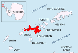
Location of Livingston Island in the South Shetland Islands.
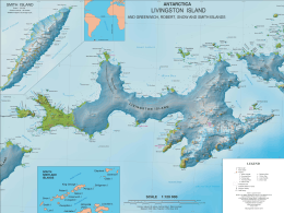
Map of Livingston Island and Smith Island.
Station P was a British base camp at the head of Mateev Cove on the east side of Hannah Point, Livingston Island in the South Shetland Islands, Antarctica that supported survey, geology and biology field work from 29 December 1957 until 15 March 1958. The area was visited by early 19th century sealers.
Location
The encampment was located at 62°38′57.5″S 60°35′25″W / 62.649306°S 60.59028°WCoordinates: 62°38′57.5″S 60°35′25″W / 62.649306°S 60.59028°W which is 1.32 km east-northeast of Hannah Point, 1.07 km south-southeast of Ustra Peak, 1.97 km southwest of Krakra Bluff, 6.88 km west by south of Ereby Point and 9.34 km northwest of Salisbury Bluff (British mapping in 1858, and Bulgarian mapping of the area in 2005 and 2009).
See also
Maps
- L.L. Ivanov et al. Antarctica: Livingston Island and Greenwich Island, South Shetland Islands. Scale 1:100000 topographic map. Sofia: Antarctic Place-names Commission of Bulgaria, 2005.
- L.L. Ivanov. Antarctica: Livingston Island and Greenwich, Robert, Snow and Smith Islands. Scale 1:120000 topographic map. Troyan: Manfred Wörner Foundation, 2009. ISBN 978-954-92032-6-4
References
- Livingston Island Station P – History. British Antarctic Survey website.
- Ivanov, L. General Geography and History of Livingston Island. In: Bulgarian Antarctic Research: A Synthesis. Eds. C. Pimpirev and N. Chipev. Sofia: St. Kliment Ohridski University Press, 2015. pp. 17-28. ISBN 978-954-07-3939-7
This article is issued from Wikipedia - version of the 11/21/2015. The text is available under the Creative Commons Attribution/Share Alike but additional terms may apply for the media files.