Bombay State
| Province of Bombay (1947 - 1950) State of Bombay (1950 - 1960) | ||||||
| State of India | ||||||
| ||||||
 | ||||||
.svg.png) | ||||||
| History | ||||||
| • | Abolition of the Bombay Presidency, Deccan States Agency and Baroda, Western India and Gujarat States Agency (partial) | 1947 | ||||
| • | Merged Kutch State | 1956 | ||||
| • | Merged Saurashtra State | 1956 | ||||
| • | Divided into Maharashtra and Gujarat states | 1960 | ||||
| Area | ||||||
| • | 1956 | 494,358 km2 (190,873 sq mi) | ||||
| Population | ||||||
| • | 1956 | 48,264,622 | ||||
| Density | 97.6 /km2 (252.9 /sq mi) | |||||
| ||||||
| States of India since 1947 | ||||||
Bombay State was a large Indian state created at the time of India's Independence, with other regions being added to it in the succeeding years. Bombay Presidency (roughly equating to the present-day Indian state of Maharashtra, excluding South Maharashtra and Vidarbha) was merged with the princely states of the Baroda, Western India and Gujarat (the present-day Indian state of Gujarat) and Deccan States (which included parts of the present-day Indian states of Maharashtra and Karnataka.
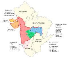
On November 1, 1956, Bombay State was re-organized under the States Reorganisation Act on linguistic lines, absorbing various territories including the Saurashtra and Kutch States, which ceased to exist. On May 1, 1960, Bombay State was dissolved and split on linguistic lines into the two states of Gujarat, with Gujarati speaking population and Maharashtra, with a largely Marathi speaking population..[1]
History
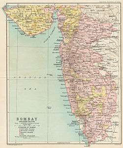
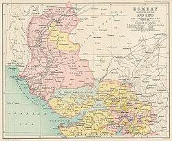
During the British Raj, portions of the western coast of India under direct British rule were part of the Bombay Presidency. In 1937, the Bombay Presidency became a province of British India.[2][3]
After India gained independence in 1947, Bombay Presidency became part of India, and Sind province became part of Pakistan. The territory retained by India was restructured into Bombay State. It included princely states such as Kolhapur in Deccan, and Baroda and the Dangs in Gujarat, which had been under the political influence of the former Bombay Presidency.[4]
Expansion of the state
As a result of the States Reorganisation Act on 1 November 1956, the Kannada-speaking districts of Belgaum (except Chandgad taluk), Bijapur, Dharwar, and North Canara were transferred from Bombay State to Mysore State.[5] but the State of Bombay was significantly enlarged, expanding eastward to incorporate the Marathi-speaking Marathwada region of Hyderabad State, the Marathi-speaking Vidarbha region of southern Madhya Pradesh, and Gujarati-speaking Saurashtra and Kutch states. The Bombay state was being referred to by the local inhabitants as "Maha Dwibhashi Rajya", meaning, "the great bilingual state".[3]
In 1956, the States Reorganisation Committee, against the will of Jawaharlal Nehru, recommended a bilingual state for Maharashtra-Gujarat with Bombay as its capital, whereas in Lok Sabha discussions in 1955, the Congress party demanded that the city be constituted as an autonomous city-state.[6] In the 1957 elections, the Samyukta Maharashtra movement opposed these proposals, and insisted that Bombay be declared the capital of Maharashtra.[7]
Dissolution of Bombay state
Bombay State was finally dissolved with the formation of Maharashtra and Gujarat states on May 1, 1960.[8]
Following protests of Samyukta Maharashtra Movement, in which 105 people were killed by police, Bombay State was reorganised on linguistic lines.[9] Gujarati-speaking areas of Bombay State were partitioned into the state of Gujarat following Mahagujarat Movement.[10] Maharashtra State with Bombay as its capital was formed with the merger of Marathi-speaking areas of Bombay State, eight districts from Central Provinces and Berar, five districts from Hyderabad State, and numerous princely states enclosed between them.[11]
Chief Ministers
Bombay State had three Chief Ministers after the independence of India:
- Balasaheb Gangadhar Kher was the first Chief Minister of Bombay (1947–1952)
- Morarji Desai (1952–1957)
- Yashwantrao Chavan (1957–1960)
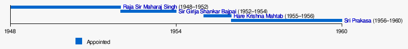
Governors
In 1960, the designation of the "Governor of Bombay" was transmuted as the Governor of Maharashtra.[12]
| # | Name | Assumed office | Left office | Years in Office |
|---|---|---|---|---|
| 1 | Raja Sir Maharaj Singh | 6 January 1948 | 30 May 1952 | 4 |
| 2 | Sir Girija Shankar Bajpai | 30 May 1952 | 5 December 1954 | 2 |
| 3 | Harekrushna Mahatab | 2 March 1955 | 14 October 1956 | 1 |
| 4 | Sri Prakasa[f] | 10 December 1956 | 16 April 1962 | 6 |
Sources: Raj Bhavan (Maharashtra)[12] and Greater Bombay District Gazetteer[13]
- Graphical
See also
- Political integration of India
- Samyukta Maharashtra movement for a separate Marathi state
- Mahagujarat Movement for separate Gujarati state.
- Indulal Yagnik
References
- ↑ Ramachandra Guha, India after Gandhi: The History of the World's Largest Democracy. HarperCollins, 2007
- ↑ Yagnik, Achyut; Suchitra Sheth (2005). The Shaping of Modern Gujarat: Plurality, Hindutva, and Beyond. Penguin Books India. p. 226. ISBN 978-0-14-400038-8. Retrieved 24 November 2012.
- 1 2 Grover, Verinder; Ranjana Arora (1994). Federation of India and States' Reorganisation: Reconstruction and Consolidation. Deep and Deep Publications. p. 392. ISBN 978-81-7100-541-3. Retrieved 24 November 2012.
- ↑ Bhattacharya, Sanjoy (2006), Expunging Variola: The Control and Eradication of Smallpox in India, 1947–1977, Orient Blackswan, p. 18, ISBN 978-81-250-3018-8, retrieved 8 January 2009
- ↑ "States Reorganization Act 1956". Commonwealth Legal Information Institute. Retrieved 1 July 2008.
- ↑ "The battle for Bombay". The Hindu. 13 April 2003. Retrieved 12 November 2008.
- ↑ "Samyukta Maharashtra". Government of Maharashtra. Retrieved 12 November 2008.
- ↑ Political and administrative integration of princely states By S. N. Sadasivan.
- ↑ "Sons of soil: born, reborn". Indian Express Newspapers (Mumbai) Ltd. 6 February 2008. Retrieved on 12 November 2008.
- ↑ "Gujarat". Government of India. Retrieved 16 January 2008.
- ↑ "Maharashtra". Government of India. Retrieved 16 January 2008.
- 1 2 "Previous Governors List". Raj Bhavan (Maharashtra). Retrieved 23 December 2008.
- ↑ "List of the Governors of Bombay", Greater Bombay District Gazetteer, Maharashtra State Gazetteers, I, Government of Maharashtra, 1986, retrieved 13 August 2008
| Part A States | ||
|---|---|---|
| Part B States | ||
| Part C States | ||
| Part D States | ||
Coordinates: 18°58′30″N 72°49′33″E / 18.97500°N 72.82583°E