Arizona State Route 79
| ||||
|---|---|---|---|---|
| Pinal Pioneer Parkway | ||||
 | ||||
| Route information | ||||
| Maintained by ADOT | ||||
| Length: | 58.40 mi[1] (93.99 km) | |||
| Existed: | 1992 – present | |||
| Major junctions | ||||
| South end: |
| |||
| North end: |
| |||
| Highway system | ||||
| ||||

State Route 79 (SR 79), also known as the Pinal Pioneer Parkway, is a state highway in the U.S. state of Arizona.
Route description
SR 79 has a northern terminus at U.S. Route 60 in unincorporated Florence Junction and passes through the town of Florence, its southern terminus is four miles (6 km) north of Catalina, at State Route 77, 25 miles (40 km) north of Tucson. The entirety of SR 79 is a direct surface route, roughly paralleling Interstate 10, (actually a north–south segment of the normally east–west freeway) and serving as the major route to Florence (which has no Interstate access), but the town of Florence is easily accessible from State Route 287, State Route 87, and Hunt Highway. It serves as the back-road to the Phoenix and Tucson Metropolitan Areas and control cities along this route show either Phoenix or Tucson.
The southern portion of SR 79 from Oracle Junction to just south of Florence is designated Pinal Pioneer Parkway, a scenic road of the high desert plain with views of the Santa Catalina and Tortilla Mountains. The 41-mile stretch of road was so designated by the Arizona Highways Department in 1961.
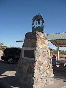
Also along this road is a memorial marker for Tom Mix, who died after his Cord 812 convertible crashed into what is now designated the Tom Mix Wash while bridge construction was incomplete. The single-car high-speed accident led to his death after leaving the Oracle Junction Inn in 1940.
SR 79 services the Florence Military Reservation which is a couple of miles north of Florence and the State, County, Private built or Federal Prisons in Florence.
It is a scenic and historic road between the metropolitan cities of Phoenix and Tucson if I-10 is closed due to an accident, weather or construction.
According to INRIX, a traffic-monitoring agency, as of 2011 Arizona State Route 79 was the fastest road in the nation, with the fastest 5% of the vehicles using it clocked at an average speed of 88 miles per hour.[2]
History
SR 79 is the section of what was together U.S. Route 80 and U.S. Route 89 before both US routes were removed from southern Arizona in 1992.
On the afternoon of October 12, 1940, silent film actor Tom Mix died in a car accident on SR 79 (then part of U.S. Route 80) 18.5 miles southeast of Florence, Arizona.[3]
Junction list
The entire route is in Pinal County.
| Location | mi[1] | km | Destinations | Notes | |
|---|---|---|---|---|---|
| | 0.00 | 0.00 | Southern terminus | ||
| | 41.12 | 66.18 | |||
| Florence | 42.42 | 68.27 | |||
| Florence Junction | 58.40 | 93.99 | Interchange; northern terminus; exit 212 on US 60 | ||
| 1.000 mi = 1.609 km; 1.000 km = 0.621 mi | |||||
SR 79 Business
| |
|---|---|
| Location: | Florence |
| Length: | 2.05 mi[1] (3.30 km) |
Business State Route 79 is a business loop in central Arizona. It lies entirely within the town limits of Florence located in Pinal County.
The road begins south of town at its parent State Route 79 near the Central Arizona Project canal and travels northbound on Main St passing a "Y" junction with State Route 287 to Coolidge. The road continues northbound to an intersection with Butte Ave, at a traffic light, where the highway turns east and passes the Pinal County Governmental Complex, it terminates at the junction with State Route 79 at the intersection of Butte Ave. and Pinal Parkway Avenue. It is the only state business loop in the state of Arizona. The junction with SR 287 and 79 is scheduled to be upgraded to a roundabout intersection. The current intersection has safety issues, including 8 driveways/entrance/exit points combining at different angles.
The business loop gives access to the historic downtown and business district in Florence, passing by the Pinal County Government Complex, Pinal County Historical Museum and 1891 Pinal County Courthouse.
References
- 1 2 3 Arizona Department of Transportation. "2008 ADOT Highway Log" (PDF). Retrieved April 9, 2008.
- ↑ "USA Today--Here are the five fastest highways in the US"
- ↑ "Mix Funeral to be Held in Hollywood". The New London Evening Day. October 14, 1940. Retrieved June 2, 2012.