Arizona State Route 387
| ||||
|---|---|---|---|---|
 | ||||
| Route information | ||||
| Maintained by ADOT | ||||
| Length: | 15.71 mi[1] (25.28 km) | |||
| Existed: | 1967 – present | |||
| Major junctions | ||||
| South end: |
| |||
|
| ||||
| East end: |
| |||
| Highway system | ||||
| ||||

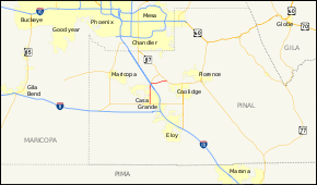
State Route 387, also known as SR 387, is a state highway in south-central Arizona, United States traveling from State Route 87 west of Coolidge west to Interstate 10, then south to its junction with State Route 84 and State Route 287 in Casa Grande.
Route description
SR 387 is a 15.71-mile (25.28 km) highway that connects Casa Grande with I-10 and SR 87. The southern terminus of the highway is located at an intersection with SR 84 and SR 287 in Casa Grande. It heads north through the city from this intersection to the Gila River Indian Reservation before reaching I-10. After the interchange with I-10, the highway intersects SR 187, with SR 387 turning towards the east at the intersection. The highway continues to the east-northeast until it reaches its northern terminus at SR 87.[1][2]
History
The stretch of SR 387 between Interstate 10 and Casa Grande was originally part of State Route 187; originally, SR 387 was concurrent with Interstate 10 northbound, and then diverged at Bapchule to rejoin SR 87 just south of Sun Lakes. The northernmost section of this route has since been renumbered as State Route 587. The route was established in 1967.[3]
Junction list
The entire route is in Pinal County.
| Location | mi[1] | km | Destinations | Notes | |
|---|---|---|---|---|---|
| Casa Grande | 0.00 | 0.00 | Eastern terminus of SR 84, western terminus of SR 287 | ||
| Gila River Indian Reservation | 8.56 | 13.78 | Exit 185 (I-10) | ||
| 8.79 | 14.15 | Southern terminus of SR 187 | |||
| 15.71 | 25.28 | ||||
| 1.000 mi = 1.609 km; 1.000 km = 0.621 mi | |||||
References
- 1 2 3 Arizona Department of Transportation. "2008 ADOT Highway Log" (PDF). Retrieved April 8, 2008.
- ↑ Google. "overview map of SR 387" (Map). Google Maps. Google.
- ↑ "Right-of-Way Resolution 1967--018". Arizona Department of Transportation. 1967. Retrieved May 15, 2011.